fluvial processes

Verifying the applicability of methods for modelling erosion and connectivity of sediments in the Slavíč catchment in the Moravian-Silesian Beskydy mountains based on geomorphological mapping of fluvial processes

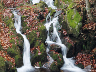
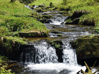
As part of the research activities of the Hydrology Department of CHMI Ostrava, field investigations and measurements are being carried out in several catchments to verify the outputs of GIS tools, empirical formulas, and mathematical models focused on surface runoff, fluvial erosion, and sediment transport. The main emphasis is placed on the influence of deforestation and land use changes on rainfall-runoff relations and fluvial erosion, especially within the framework of the NAZV “DEFOREST” and “CLIMCFOR” projects, in which CHMI collaborates with the Forestry and Game Research Institute (VÚLHM), the Bishopric of Ostrava-Opava, and Water Management Development, and Construction joint stock Company (VRV). The presented article deals with the possibilities of analysing fluvial processes and disconnectivity of flows in the Slavíč catchment in the Moravian-Silesian Beskydy Mountains. ESRI ArcGIS and GRASS GIS tools were used for these analyses. Field verification of outputs took place at several sampling points within the main stream Slavíč.

Study of stream morphological changes and its application in the design of environmentally acceptable channels

Climatic change is manifested in a number of places by significantly spatially localized torrential rainfall with a short duration, but with great inten-sity. One of the expected consequences of this type of precipitation is the occurrence of flash floods, characterized by a sharp rise from the value of the normal flow to the value of the peak flow and a rapid decrease again. The consequence of this type of short episodic floods is the initiation of morphological transformations in the beds of smaller and medium upland streams, often with devastating effects for the section of the watercourse channel. The article summarizes research on the formation and development of a scour hole in the section at the transition from a lined riverbed with fixed bed and banks to the riverbed with loose channel boundry which can be transformed morphologically in an uncontrolled manner. In this re-search, the main attention was paid to the formulation of a parametric model of the scour hole morphological development at the transition between a lined and an unlined channel. The results of this model can be used both to understand the hydraulic-morphological processes that occur at the site of a sudden river bed change, and for the practical design of restoration modifications to the river bed at the transition from a fully lined to an un-lined river bed without any protective measures, approaching the original pristine conditions.