SUMMARY
The Výrovka river basin, as a compact area covering 542.5 km2, is very suitable for monitoring hydrological characteristics and comparing them in different landscape types. It is located on the border of the Lower Vltava and Upper and Middle Elbe sub-basins, extending in a range of 175–555 m above sea level, with a total of six landscape types according to the typology of the contemporary landscape of the Czech Republic. Simultaneously, there is a varied mosaic in terms of geological subsoil and soil types. There have also been major changes in land use in this basin, mainly due to intensive agricultural activity and related watercourse modifications and amelioration. Monitoring activities within the project SS02030027 ”Water systems and water management in the Czech Republic in conditions of climate change” are currently taking place in the Výrovka river basin.
INTRODUCTION – PAST AND PRESENT ACTIVITIES IN THE VÝROVKA RIVER BASIN
In the past, several expert articles were published about the Výrovka river basin, dealing mainly with historical development of the landscape and change of land use, or the changing location of wetland habitats [1–3]. Part of the Výrovka river basin was chosen as one of the sites analysing the change of wetlands in the landscape of lowlands and hills of the Czech Republic [4]. Recently, on the initiative of the Central Bohemian Region and with support from the Operational Programme Environment, a study of runoff conditions and proposals for possible flood control measures in the Výrovka river basin was completed [5, 6]. The Local Action Group (LAG) Podlipansko, o. p. s., [5, 7] significantly participated in the implementation of this study. The above articles and the current study show that the Výrovka river basin is a suitable model area for proposing measures to improve water retention in the landscape, representing densely populated and intensively agriculturally used areas of Central Bohemia, specifically the Elbe river basin.
For the needs of other projects, a detailed analysis of the area presented in this article was performed. Currently, the Výrovka river basin is used as a model river basin to identify the origin of pollution sources for selected indicators causing failure to achieve good surface water status according to Directive 2000/60/EC of the European Parliament and of the Council (Water Framework Directive) in the TA CR project SS02030027 ”Water systems and water management in the Czech Republic in conditions of climate change”. Within this project, in 2021–2022, selected environmental components are monitored in the Výrovka river basin and, based on this monitoring and other available data, the significance of individual pollution sources and pollution routes for this river basin will be evaluated and general conclusions drawn; if needed, the follow-up monitoring programme will also be updated.
VÝROVKA RIVER BASIN
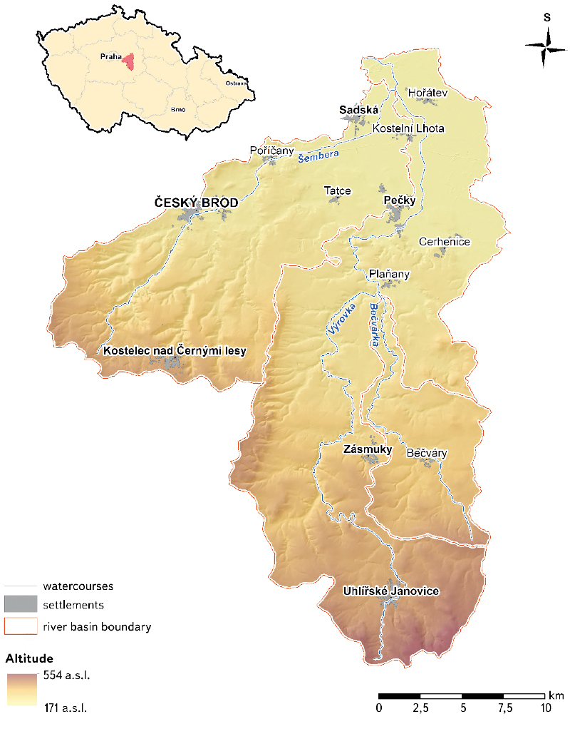
The Výrovka river basin is located in the Central Bohemian Region in the districts of Kutná Hora, Kolín, Nymburk, and Praha-východ. In terms of altitude, the area extends between 175–555 m a.s.l. The Výrovka springes at 493 m a.s.l. near Kochánov (part of Uhlířské Janovice); other significant watercourses in the basin are the Bečvárka, rising near Miletín at 440 m a.s.l., and the Šembera, rising near Vyžlovka at 404 m a.s.l. The confluence of the Výrovka and Bečvárka is in the area of Zalešany-Žabonosy-Plaňany, at an altitude of 219 m. This is followed by the confluence of the Výrovka and Šembera at 184 m a.s.l. near the village of Zvěřínek; after 3.5 km, near the village of Písty, the Výrovka flows into the Elbe at an altitude of 175 m [8] (Fig. 1).
Fig. 1. The 3rd order Výrovka river basin in terms of hydrology and altitude – data source [8]
HYDROLOGY
The entire territory of Výrovka 3rd order basin 1-04-06 is located in the Elbe basin at the boundary of the Lower Vltava and Upper and Middle Elbe sub-basins.
It covers 542.5 km2 and consists of 54 river basins of the 4th order (hydrological basin – HLGP). However, from the point of view of hydrology, this river basin can be divided into two, or even three, parts. There are two main watercourses in the Výrovka river basin: the Výrovka and Šembera. The Šembera should, according to most characteristics, form a separate river basin; but they have a common river basin due to the fact that the Šembera flows to Výrovka 3.5 km before Výrovka enter the Elbe, where both watercourses fall within 5th order of watercourses according to Strahler. The Výrovka has as a significant right-bank tributary, the Bečvárka, which flows into the Výrovka before Plaňany, at its 23.2 river km. According to the Strahler order of watercourses, at the confluence the Výrovka is in the 5th order and Bečvárka in the 4th order. From this point of view, the Výrovka 3rd order basin 1-04-06 can be divided into three parts: the Výrovka basin, consisting of 31 HLGPs with an area of 289.1 km2; the Bečvárka basin, consisting of 7 HLGPs with an area of 64.3 km2; and the Šembera basin, consisting of 16 HLGPs with an area of 189.1 km2. The length of the Výrovka watercourse is 61.8 km, the Bečvárka 22.9 km, and the Šembera 28.2 km; the Výrovka watercourse in its upper part and the entire Bečvárka watercourse are significantly more fragmented than the Šembera watercourse [8] (Fig. 1).
LANDSCAPE COVER AND TYPOLOGY OF THE CURRENT LANDSCAPE OF THE CZECH REPUBLIC
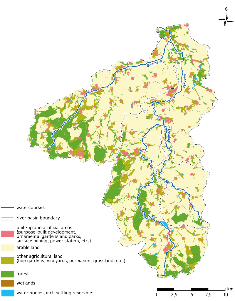
According to ZABAGED® land cover classification [9], arable land (67.74 %) prevails in the Výrovka 3rd order basin 1-04-06; a significant part is also covered by forests (16.20 %) and other agricultural areas (10.74 %). In contrast, the representation of water bodies and wetlands is marginal (0.74 % and 0.07 %, respectively). Built-up and artificial areas cover 4.51 % of this basin.
In terms of landscape cover within the river basin, arable land is most represented in the Bečvárka river basin (78.89 %); in the Výrovka and Šembera river basins it is 67.85 % and 63.79 %, respectively. Forests occupy the largest area in the Šembera and Výrovka river basins (especially in higher altitudes and spring areas): 19.36 % and 15.57 %, respectively; it is 9.75 % in the Bečvárka river basin. Other agricultural areas and built-up areas show a similar relative composition within individual river basins. The least abundant (but for the landscape very important) types of land cover, i.e. water bodies and wetlands, occur most in the Bečvárka river basin. In the remaining two river basins, the representation of water bodies differs; it is higher in the Výrovka river basin, while wetlands occur more often in the Šembera river basin (Tab. 1; Fig. 2).
In the entire Výrovka 3rd order basin 1-04-06, there are six types of landscapes according to the typology of the current landscape of the Czech Republic. Three general types of natural landscapes and three functional landscape types. There are a total of three general types of natural landscapes in the catchment area. The source areas of the Výrovka and also partly the Bečvárka are in a slightly cool landscape of hills and highlands, the upper part of the Výrovka, Bečvárka and Šembera river basins, including the spring area, are in moderately warm landscapes of basins and hills, and the rest of the whole basin is located in warm lowlands. There are also a total of three functional landscape types in the catchment area. The source areas of the Výrovka, and partly also the Bečvárka and the upper part of the Šembera river basin, are in the forest-field landscape; the source parts of the Šembera river basin are located in the field landscape with forests and heterogeneous agricultural areas. The rest of the whole river basin falls within the field landscape [10].
Fig. 2. Map of land cover in the 3rd order Výrovka river basin – data source [9]
Tab. 1. Representation of land cover classified according to ZABAGED® [9] in individual parts of the catchment area of the 3rd order Výrovka river basin

GEOLOGY
Geologically, the entire Výrovka river basin is part of the Bohemian Massif. The geological composition of the area is relatively diverse, while the geological interfaces do not correspond exactly to the hydrological watersheds.
The subsoil of the upper and middle Výrovka is mainly part of the Kutná Hora crystalline basement of the Kutná Hora-Svratka region. The rocks of the Kutná Hora crystalline basement are represented mainly by orthogneiss to migmatites, mica-schists to schist gneisses, etc. To a lesser extent, there are also more subsilicic metamorphic rocks, such as serpentinites (body near Bečváry), amphibolites, and similar rocks.
The subsoil of the upper and middle Šembera are of the Permocarbon structure of Blanická brázda, the southwestern part is of the Central Bohemian pluton. The sedimentary filling of the Blanická brázda consists mainly of breccias, conglomerates, sandstones, arkoses, siltstones, and claystones. The Central Bohemian pluton is mainly represented by biotite granite from Říčany.
Denudation relicts of sediments of the Czech Cretaceous Basin occur on older rocks in the Výrovka and Šembera river basins. Sedimentation began with the Peruc–Korycany Formation of the Cenomanian age. Locally, there are basal Peruc layers, which are mainly composed from sandstones, siltstones, claystones, and conglomerates. The overlying Korycany strata are formed mainly by marine sandstones. Above them, the marine sediments of the Bílá Hora Formation of the Lower Turonian age have been preserved, consisting of marlstones, claystones, limestones, spiculites, calcareous sandstones, and siltstones. The thickness of Upper Cretaceous sediments generally increase from south to north. The confluence area of the Výrovka and Šembera is thus built of Czech Cretaceous Basin rocks; the underlying older rocks no longer rise to the surface. The highest member of the Upper Cretaceous sedimentation is represented by the denudation relics of the Jizera Formation of Middle Turonian age, especially kaolinic sandstones, marlstones, and limestones.
The surface of both compared river basins is covered by Quaternary sediments. Pleistocene Aeolian sediments – loess and loess clays are significantly represented. Especially in the north of the area there are Pleistocene fluvial sandy gravels of river terraces. Diluvium’s are very widespread – diluvial aluminous-sandy and aluminous-stone sediments. There are also anthropogenic deposits, such as material from construction and landfilling [8, 11].
HYDROGEOLOGY
From the hydrogeological point of view, the area of interest is part of the hydrogeological regions of the base layer 6531 – Kutná Hora crystalline basement, 4350 – Velim Cretaceous and 4360 – Elbe Cretaceous. In the northern part of the area of interest, there is the Upper Layer District 1152 – Elbe Quaternary up to Nymburk.
The upper and middle basin of the Výrovka form hydrogeological district 6531 – Kutná Hora crystalline basement. The crystalline rocks have slight fracture permeability. From the hydrogeological point of view, the shallow aquifer in the Quaternary sediments and the zone of subsurface disengagement of rock fractures is dominant in the area of interest with the crystalline bedrock. The area is usually only suitable for smaller groundwater abstraction for local supply.
The upper and middle basin of the Šembera are mostly part of the hydrogeological district of the base layer 4350 – Velim Cretaceous. Most of the subsoil of the area consists of Permocarbon sediments of the Blanická brázda. These are characterized by irregular alternation of aquitards and collectors with fracture and intrinsic permeability and are generally more permeable than crystalline basement in the Výrovka river basin.
Of the overlying relics of Cretaceous sediments, psammitic Cenomanian sediments tend to be very permeable. They occur either as denudation relics alone or are partially covered by younger formations of the Czech Cretaceous Basin. The most widespread collector of the area of interest is the so-called basal Cretaceous collector, from which groundwater is locally obtained for the municipality needs.
Another very permeable environment is the fluvial psammitic sediments of river terraces and floodplains of larger streams. Groundwater is pumped from them for smaller villages in the area. Other Quaternary sediments are less permeable, such as loess, diluviums, and flood clays. Some of them have the character of local aquitards.
The confluence area of the Výrovka and Šembera is in the hydrogeological district of the base layer 4360 – Elbe Cretaceous and to Upper Layer District 1152 – Elbe Quaternary up to Nymburk. From a hydrogeological point of view, the area is generally much more permeable than the upper and middle parts of the Výrovka and Šembera river basins. This is mainly due to the highly permeable fluvial gravel and sands of river terraces, which cover most of the area.
The second important aquifer is the basal Cretaceous aquifer in the Cenomanian sandstones. In contrast, less permeable rocks form (semi) aquitards here, such as marlstones and Turonian claystones, flood clays, and loess; these are not very favourable for the formation and circulation of groundwater [8, 12–14].
GROUNDWATER – SUMMARY
The height of the groundwater level in this basin depends on the morphology of the terrain, local permeability, and precipitation totals. In general, the water level at higher elevations is the deepest, and in valleys near watercourses it is closer to the surface.
Regarding the occurrence of a significant amount of groundwater, the crystalline basement in the upper and middle catchments of the Výrovka and Šembera is rather a deficit area. Better conditions are found within the denudation relics of the Cretaceous sandstones, more permeable Quaternary sediments along watercourses, and in the Permocarbon rocks of Blanická brázda. The confluence area of the Výrovka and Šembera has the best conditions for concentrated abstraction of higher amounts of groundwater; this is due to important collectors in the Quaternary gravel of river terraces and in the Cretaceous sandstones [8, 11–14].
PEDOLOGY
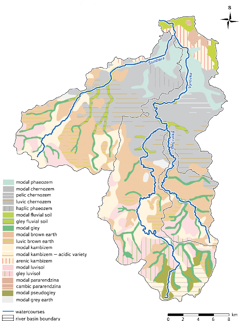
Soil conditions in the entire Výrovka river basin are very diverse; there is a wide range of soil types (Fig. 3). In the immediate vicinity of the watercourses, there are mainly:
- pseudogley (characterized by the presence of a pronounced marbled, redoximorphic diagnostic horizon due to alternating flooding and drying of the soil profile),
- fluvial soil (with fluvic diagnostic features caused by periodic sediment deposition and the occurrence of new formations which develop when water infiltrates during a flood),
- gleys (with a significant reductomorphic diagnostic gley horizon due to long-term saturation with high groundwater levels),
- phaeozems (deep-humus semi-hydromorphic soils developed from unconsolidated carbonate or at least sorption-saturated substrates with a phaeozem horizon, with a third degree of hydromorphism, indicated by a higher humus content than the surrounding chernozem, and with redoximorphic traits in the humus horizon and in the substrate).
In the wider vicinity of the rivers in the basin, these are:
- chernozem (deep humus soils developed from carbonate sediments),
- brown soils (soils with a profile differentiated into a slightly lightened eluvial horizon, transitioning without linguoid infiltrations to a homogeneous brown luvic horizon),
- cambisols (soils that are formed mainly in sloping conditions, to a lesser extent in flat relief, with a wide diversity in terms of their properties),
- grey earth (soils with the presence of the luvic horizon with dark clays, located locally on the periphery of the chernozem extension from loess),
- pararendzina (soils from disintegrations and from basal and shallow main formations of carbonate-silicate consolidated rocks, occurring in different climatic conditions, mainly in the areas of Cretaceous and flysch consolidated sediments).
Fig. 3. Map of soil types in the 3rd order Výrovka river basin – data source [8, 15]
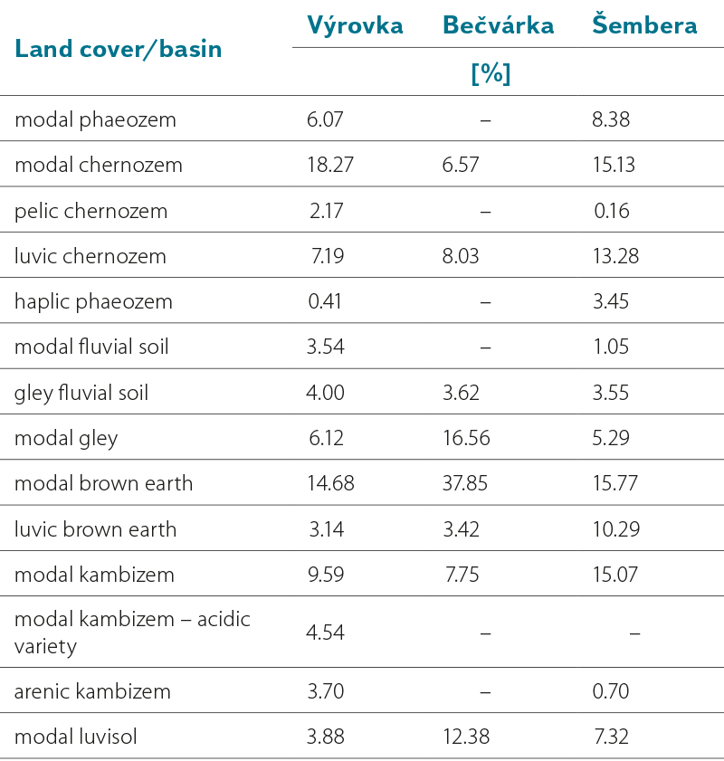
The relative representation of soil types in individual river basins is shown in Tab. 2. In terms of soil-forming substrates, polygenetic clays and glacial deposits, dust loam, gneiss deluviums, loess, solid and consolidated sedimentary rocks, and others are found in the monitored area [15].
Tab. 2. Representation of soil types in individual parts of the catchment area of the 3rd order Výrovka river basin

In connection with the diversity of the monitored area, we can also observe different levels of threat to agricultural land by water erosion in individual river basins [16]. It is – in addition to the characteristics of the relief – the result of the creation of large plots without anti-erosion measures and the cultivation of row crops on slopes [15]. In the upper areas of watercourses in particular there is a large proportion of soils which are slightly or severely threatened by erosion. In the lower parts, in the places where the Bečvárka and then the Šembera join the Výrovka (eventually flowing into the Elbe near the village of Písty), soils not endangered by erosion predominate. In the Bečvárka river basin, soils highly endangered by erosion are located in the area of the source near Miletín (brown earths, cambisols), to a greater extent in the section between the villages of Červený Hrádek and Bečvárky (brown earths, luvisols), around Mlýnský (Podbečvárský) pond (brown earths) and in front of confluence with Výrovka between Přeboz and Žabonosy (chernozems). In the case of the Výrovka river basin, there are soils severely endangered by erosion in the initial parts of the watercourse near Uhlířské Janovice (pseudogleys, cambisols), then also in the section between Zásmuky and Pečky (brown earths, cambisols, luvisols), especially in the vicinity of municipalities and cities, where there are large, agricultural lands. In the case of the Šembera river basin, the situation is similar; the most soils endangered by erosion are found in the vicinity of towns and villages; large areas with the highest degree of threat lie in the zone between the villages of Masojedy, Mrzky, and Tismice (luvisols, brown earths, cambisols). In the immediate vicinity of the Šembera watercourse, it is mainly around Mlýnský and Podviňák ponds before Český Brod (brown earths, cambisols), to a lesser extent in the vicinity of Poříčany and Sadská (chernozems, phaeozems) [16].
DISCUSSION AND CONCLUSION
The Výrovka river basin is a compact area covering 542.5 km2; due to its diverse landscape mosaic and an appropriate number of landscape types from the typology of the contemporary Czech landscape, as well as for its diversity of geological subsoil and represented soil types, it is very suitable for monitoring and comparing landscape types and hydrological characteristics, especially the status of surface waters under the Water Framework Directive. In particular, the different characteristics in the upper and lower part of both the entire 3rd order basin and the individual river basins of the three most important watercourses (i.e. Výrovka, Bečvárka, and Šembera) provide suitable conditions for studies dealing with differentiation of proposed measures, dependant on different landscape and hydrological characteristics in this river basin, which could then be applied to similar types of territory within the Czech Republic. The Výrovka river basin has also undergone major changes in terms of land use, caused mainly by intensive agricultural activity and related watercourse modifications and land reclamation. The proposed activities within the Study of runoff conditions, including proposals for possible anti-flood measures in the Výrovka watercourse river basin are partially trying to respond to this situation. Within this study, field surveys of the area were carried out and a hydrotechnical inspection of water works (pond dikes, culverts, piping and watercourse beds) took place. Among other things, the collected data showed that, in the upper part of the river basin, there is excessive surface runoff with a large loss of soil from agricultural land, which clogs the riverbeds and reservoirs. This finding is consistent with the results reported in the pedology chapter of this article. Rapid runoff causes a risk of floods and was the main cause of floods in the Výrovka river basin in 2013. In the lower part of the river basin, the state of watercourses needs to be improved to avoid rapid runoff of rainwater from the river basin, and subsequent floodplain drainage [5]. One of the measures developed into the documentation phase for issuing a decision on the construction location is the proposal of semi-natural restoration of the Výrovka watercourse, including the floodplain at 4.39–10.70 river km [6]. After project completion in individual cadastral areas, these documents will be available to municipalities, which can project them into their zoning plans or land adjustments; however, the study does not include the financing of the proposed measures.
These measures should increase the flood protection of endangered buildings and reduce the negative effects of water and wind erosion as well as drought. Podlipansko LAG is prepared to provide assistance in finding financial resources for the implementation of the proposals arising from this study [5]. It would be appropriate for other associations of municipalities to be involved in such activities, as it now seems to be a suitable procedure for enforcing changes with a positive effect on water retention in the landscape. Following this study, a strategy for adaptation to climate change was developed for the territory of Podlipansko LAG, where the analytical part presents, among others, the meteorological characteristics, assessment of erosion and flood risks, and maps of sources and wetlands [7]. However, the historical state of the landscape is not taken into account here, which is important for the indication of sites suitable for the restoration of water retention elements in the river basin.
The above study covers a significant part of the Výrovka river basin and focuses mainly on proposals for restoration of watercourse beds, an inventory of ponds and reservoirs, as well as on the assessment of the area‘s vulnerability to climate change. It is certainly a commendable act, which seems to be a breakthrough in terms of the approach of state administration and local authorities to the current problems caused by climate change in combination with contemporary farming in the landscape.
Despite the above facts, there is still significant scope for designing landscape adjustments in the entire Výrovka river basin in order to retain water in the landscape, and to improve the chemical and ecological status of surface waters under the Water Framework Directive. The expected results of ongoing monitoring could possibly be used for this.
The subject is very topical. Although the issue of long-lasting drought has been a burning problem in the Czech Republic for a long time – since 2014 we have been experiencing an almost constant threat of drought; however, to this date, neither systematic proposals have been made, nor any specific measures in the landscape have been taken that would at least partially eliminate this situation. That the climate is changing and that the distribution of precipitation during the year is different from previous decades is evident, for example, in the adoption of emergency measures for periods of prolonged drought.
As for now, a period of prolonged drought was declared throughout the Central Bohemian Region on 24 March 2022, until further notice. This happened on the recommendation of the Fire and Rescue Service of the Central Bohemian Region due to the current drought and an increase in the number of wildfires, as well as taking into account Czech Hydrometeorological Institute forecasts [17]. The measures taken in the countryside in connection with a period of prolonged drought include, among other, a ban on open fires, smoking, operating steam locomotives, and using water from fire-fighting sources for purposes other than fire-fighting [17, 18]. These bans could be expected in the summer months, when a period of prolonged heat is not unusual; however, it is only the end of March (this article was created at the end of March 2022, ed. note), and such a measure is not taken for no reason from day to day. Therefore, it is very important to return water to the Czech landscape through the massive implementation of appropriately designed measures leading to water retention
in the landscape.
Acknowledgements
The article was created within the internal grant of TGM WRI, p. r. i., No. 3600.54.03/2021 and the TA CR research project Environment for Life SS02030027 ”Water systems and water management in the Czech Republic in conditions of climate change”.
This paper has been peer-reviewed.


