ABSTRACT
The article documents the course of the flash flood at the beginning of June 2024 in Brdy PLA, in the Příbram Region, including reflection on its causes and possibilities for limiting the consequences of this type of flood in the future. Publicly available information was evaluated from the hydrometeorological situation in the Archive of weekly reports on the CHMI website for the nearest station to the flood-affected area, namely Neumětely station. In that week, the highest weekly precipitation total for the Czech Republic was recorded at Neumětely station. When evaluating landscape development based on archival maps or orthophoto maps, changes with some negative effects on water retention in the landscape were observed. It was mainly the gradual expansion of urban development into the original mosaic of dry or wet meadows and small fields, straightening and piping of watercourses, ploughing their floodplains, land reclamation of spring areas, and their subsequent replacement with arable land.
INTRODUCTION
The Brdy Highlands are over 70 km in length and cover an area of 827 km2. The highest point is Tok hill (865 m above sea level), which is part of the central Brdy hills. This is the highest part of the Brdy, which was part of a military district and is now the centre of a PLA [1–3]. The Brdy hills are characterized by poor subsoil, which does not allow the formation of more fertile soils. These are concentrated only in the valleys of watercourses. This is why, during medieval colonization of the Brdy region, settlements appeared only in these lower-lying locations, and the rest of the range remained forested [4]. Although the landscape in Brdy PLA seems unaltered at first glance, it has undergone many changes over the last two centuries. These were not only the changes in the species composition of the extensive Brdy forests, but especially the non-forest areas around settlements, whether existing or disappeared. The Brdy landscape was also significantly influenced in the 20th century due to military activities [5].
Extreme hydrological phenomena are recorded in the oldest historical sources. From the perspective of dealing with the consequences of floods and droughts, various technical and organizational measures have been proposed which are intended to protect mainly built-up areas from floods or, conversely, retain water in the landscape for periods of drought. In the past, people had to rely on their observations and the experience of their ancestors, who knew where the water caused damage during floods. If they did not do so, they would lose crops, livestock, property, or even their lives. If necessary, they built small water management structures in forests, fields, in and along streams. They knew where not to build their homes and what to do when a flood or drought came. It was the so-called “flood memory”, which they could rely on. Currently, awareness of flood memory is declining, and long-term experience is often no longer shared and respected, whether it is due to people becoming more detached from nature, focusing on other life priorities, or perhaps because of expectations of government help in times of emergency.
The following text documents the course of a flash flood in Brdy Protected Landscape Area in the Příbram region, specifically in the cadastral areas Drahlín and Sádek, on 2 June 2024. Several such flash floods normally occur in the Czech Republic during a year; some years there are more, others fewer. As a rule, they do not occur in the same locations, but given ongoing climate change, previous experience cannot be completely relied on. There are certainly locations that are more susceptible for various reasons. These types of floods are usually not as publicized and will not cause such overall damage as the catastrophic regional floods affecting a large part of the Czech Republic, which occurred in July 1997, August 2002, June 2013 or most recently in September 2024, or as in Spain at the end of October 2024 in the Valencia area, or at the beginning of November 2024 in the Barcelona area.
LOCATION DESCRIPTION
The flood described here is documented in the area of the cadastral area Drahlín and the neighbouring, lower-lying cadastral area Sádek, which are located in the municipalities of Drahlín and Sádek in Příbram district in the Central Bohemian Region. This cadastral unit directly borders Brdy PLA, where the cadastral areas Drahlín in Brdy and Sádek in Brdy are located on the site of the former Brdy Military District. From a hydrological point of view, this area is located in the Berounka sub-basin, in the second order basin 1-11 Berounka from Úslava to the estuary in the third order basin 1-11-04 Litavka and Berounka from Litavka to Loděnice, and in the fourth order basin 1-11-04-0100 Drahlínský stream. Drahlínský stream itself is 4.81 km long and its catchment area covers 7.85 km2 [6] (Figs. 1 and 2).
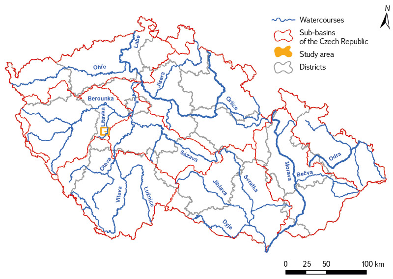
Fig. 1. The researched area in a hydrological context
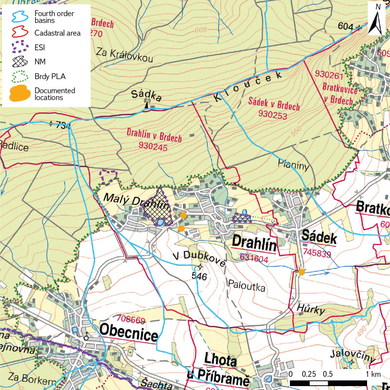
Fig. 2. The researched area on current ZTM 50
The geological subsoil consists of gravels, sands, conglomerates, and sandstones [7]. According to the MKSP classification, the predominant soil types are pseudogley cambisol and primary pseudogley. In the floodplain of the Drahlínský stream and its nameless left-hand tributary, typical gley predominates, while in forest stands, it is dystric cambisol and ranker [8]. Based on the geomorphological division, the area is located on the border of the Třebská pahorkatina and Třemošenská vrchovina districts, which are part of the Brdy Highlands geomorphological unit, located in Brdy region [1, 2, 9]. Drahlín cadastral area contains Drahlínské louky Nature Monument, which is also a European Site of Importance (ESI) in the Natura 2000 system. It was declared as an ESI covering 12.6 ha on 3 November 2009 and as a Nature Monument covering 13 ha on 22 July 2016. It consists of two separate meadows on the eastern and western edges of the built-up area near both ponds in Drahlín cadastral area. On 19 April 2024, Licitanta Nature Monument was declared in the same cadastral register covering 2.7 ha, which also belongs within Brdy PLA [10].
Brdy PLA and the former Brdy Military District
The history of the Brdy Military District began in the 1920s, when the then Ministry of Defence of Czechoslovakia established a new artillery range to increase the amount of artillery and modernize weapons. Brdy was chosen as the new area for the training ground as its terrain resembled border areas and seemed to be an ideal location for military purposes. However, this did not please the civilian population, which led to a strong wave of resistance [2, 11]. The creation of the shooting range was protested against not only by residents, who were threatened with eviction, but also by a number of prominent national figures – scientists, writers, poets, and others. A group of parliament members also rebelled, submitting a proposal in 1920 to establish a national park in the Brdy hills, which would prevent the area from being occupied by the army. However, the protests (the strongest in 1924 and 1925) were in vain and, on 19 February 1926, the government approved the project. The construction of the shooting range began on 14 July 1927 and was completed in the same year [2, 12]. The following year, the headquarters of the military artillery training ground and the headquarters of military forestry enterprises were established. In 1929, barracks and residential buildings for military employees were built and a section of forest was cut down to build new target impact areas [2, 11]. However, the army did not prohibit anyone from entering the area at that time; the place was busy with tourists. A ban was limited to the target impact areas only. The German army, which began using Brdy shooting range during the occupation, expanded it westward and evicted the original inhabitants. However, because the German army left all the buildings in the area, the inhabitants were able to return after the war. In the early 1950s, the entry ban was reinstated and, in 1952, the area began to expand again. Most of the buildings were razed to the ground and only a few gamekeepers’ lodges remained [2, 12]. Other buildings included the Tři Trubky hunting lodge and the ruins of Valdek Castle. In the 1990s, there were further attempts to abolish the military district or reduce the military area, to declare Brdy a protected area and to open it to tourists. However, the Ministry of the Environment rejected these proposals, as the military area was protected from the influences of civilization [13]. After long negotiations, based on Act No. 15/2015 Coll., on the abolishment of the Brdy military district, on the determination of the borders of military districts, on the change of regional borders and on the amendment of related laws (the Act on the Borders of Military Districts), Brdy military district was finally abolished on 1 January 2016 and changed to PLA. After its abolishment, it was divided into 27 cadastral areas of which 11 cadastral areas fell under Příbram district, six under Beroun district, seven under Rokycany district, and three under Plzeň-south district [14].
METHODOLOGY
The first step was to select areas suitable for observing and documenting the onset of flash floods so that they would be relatively quickly accessible from Prague. The presented locations of Drahlín and Sádek, on the borders of Brdy PLA, meet these conditions. The next step was a field survey of these locations to verify their current condition, both during the ongoing flood and under standard conditions. After that, publicly available hydrometeorological situation information in the weekly reports archive on the CHMI website were evaluated [15].
Subsequently, a comparison of the current and historical state of the study area was carried out based on the interpretation of map data. To display the historical state of the landscape within various types of comparison, the following maps were used: Maps of the Stable Cadastre, the Map of the 2nd Military Mapping, the Historical Orthophotomap from the 1950s, and archival orthophotomaps. To display the current state, the current Basic Topographic Map of the Czech Republic 1 : 10,000 (ZTM 10) and 1 : 50,000 (ZTM 50) and the current Orthophotomap of the Czech Republic were used.
Current map data used
Current ZTM 10, ZTM 50 and Orthophotomap of the Czech Republic
These maps are available via WMS or WMTS from the ČÚZK Geoportal [16], where they are continuously updated as needed. The displayed state on ZTM 10 and ZTM 50 may differ according to individual segments, which are updated separately (e.g. road network), and therefore may not display the actual state of the landscape in all respects in a given period. Currently, both maps should correspond to the state of the landscape in 2020–2023. The entire Orthophotomap of the Czech Republic is updated in a two-year cycle. Approximately one half of the Czech Republic is updated annually, and since 2020, regional borders have been taken into account in the update.
Archival map data used
Stable Cadastre
The oldest usable map material with a detailed depiction of landscape cover is maps of the Stable Cadastre, or more precisely, Imperial Imprints of the Stable Cadastre. They record the historical state of the landscape from the mid-19th century. They were produced at a scale of 1 : 2,880, or 1 : 5,760 in mountainous areas. The original maps were drawn in the field and capture the actual state of the landscape before the industrial revolution, i.e. in 1824–1836 (Moravia and Silesia) and 1826–1843 (Bohemia). Their disadvantage when used for landscape change analyses in a GIS environment is the need to georeference individual map sheets. Viewing and ordering is possible on the website of the Archive Maps of the Central Archives of Surveying and Cadastre [17].
Map of the 2nd Military Mapping
This is the first relatively precise topographic map. It was drawn on a scale of 1 : 28,800 in 1836–1852. Its creation was preceded by military triangulation, which was the geodetic basis of this work. The material used were the Maps of the Stable Cadastre. The map of the 2nd Military Mapping was created at the time of the onset of the Industrial Revolution and the development of intensive forms of agriculture, when the area of arable land increased by half in 100 years and the area of forest reached a historical minimum. The first railway lines are also recorded here [18]. It is available for viewing on the National Geoportal INSPIRE [19] and also as WMTS [20]. Individual map sheets can be searched within the oldmaps.geolab.cz application of the Geoinformatics Laboratory of the Faculty of Environmental Sciences of J. E. Purkyně University in Ústí nad Labem [18].
Historical orthophotomap from the 1950s
The historical orthophoto map includes layers of aerial photographs mainly from 1952–1954, supplemented by images from 1937–1970 and 1996 where relevant photographic data do not exist for the given period. The Orthophotomap of the Czech Republic from historical images of the first nationwide aerial photography from the 1950s was created as part of the National Inventory of Contaminated Sites (NIKM) project. Aerial survey images were provided by the Military Geographical and Hydrometeorological Office (VGHMÚř) Dobruška and processed by GEODIS BRNO, s. r. o. It is available for viewing on the National Geoportal INSPIRE [19] and also as WMTS [20].
Archival orthophotomaps
These orthophotomaps are available as WMS from the ČÚZK Geoportal. Only the part of the area that was photographed within one year is always displayed, according to the stages of photography in the Czech Republic in 1998–2021.
In the layers from 1998 to 2001, the data is displayed in black and white, the layers from 2003 contain colour images [16].
FLASH FLOOD ON 2 JUNE 2024 IN THE DRAHLÍN AND SÁDEK MUNICIPALITIES
On 2 June 2024, there were thunderstorms and torrential rain in the Brdy region. This precipitation wase very intense and the Litavka inundated in Příbram, Bratkovice, and further downstream. The Litavka is the main river in the area, so its inundation was quite expected in this meteorological situation. However, the onset of the flood was also very rapid in the Drahlínský stream basin. Torrential rainfall in the villages of Drahlín and Sádek and their surroundings caused the basements of several houses in these villages to flood. Water poured from the forest, which is part of Brdy PLA, and also caused temporary impassability of some sections of roads, which complicated the work of firefighters in pumping water out of flooded basements [21]. The consequences of this flood were documented in the area of the piping and canalization of a small stream below the main road in the village of Drahlín, where the stream inundated. The sewerage system was not able to absorb such a large amount of water, causing it to overflow across the main road and subsequently flood the basements of several properties in the area. The situation as of 2 June 2024 compared to standard situation is shown in Figs. 3 to 6. In built-up areas, a very common issue in recent years has been undercapacity of riverbeds, undercapacity of bridges and culverts, clogged culverts that are not sufficiently managed, and undercapacity of watercourse piping (often all together). The above-mentioned situation only confirms this issue.
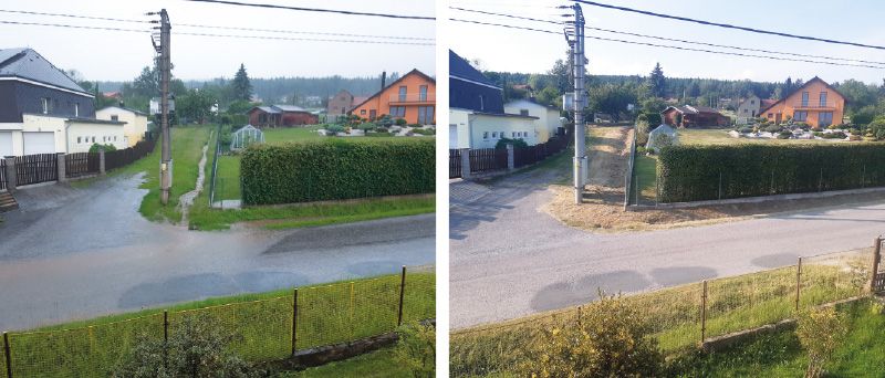
Fig. 3. Situation in the area of piping and canalization of a small stream below the main road in the village of Drahlín during the flash flood in June 2024 compared to standard situation at the end of August of the same year
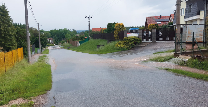
Fig. 4. Situation in Drahlín on the main road towards Obecnice in the area of piping and canalization of a small stream during the flash flood in June 2024
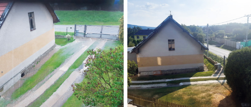
Fig. 5. Situation in Drahlín below the main road in locality no. 121 and 122 during the flash flood in June 2024 compared to standard situation at the end of August of the same year
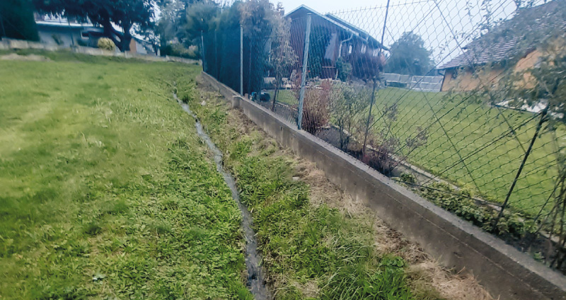
Fig. 6. Minor watercourse near the main road, standard situation (October 2024)
The pond in the eastern part of the village could not hold such a large amount of precipitation either. Drahlínský stream below this pond inundated and the adjacent local road was flooded (Fig. 7) [21]. The above-mentioned documented sites in the Drahlín cadastral area in the context of landscape development are shown in Fig. 8.
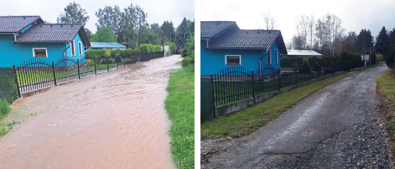
Fig. 7. Flooding of local roads in Drahlín in June 2024 (Drahlínský zpravodaj [21]) compared to standard situation in November of the same year
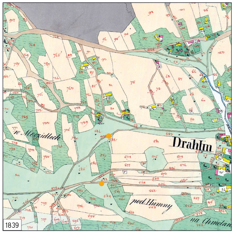
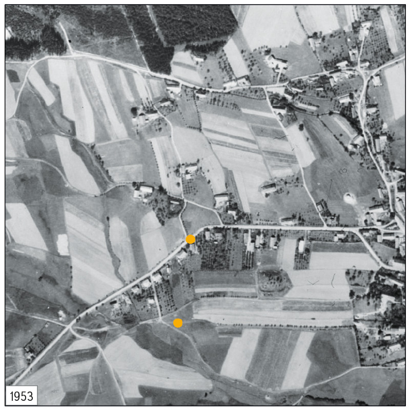
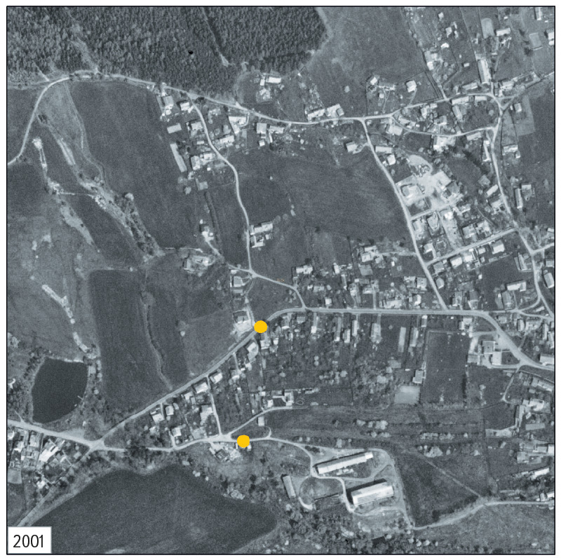
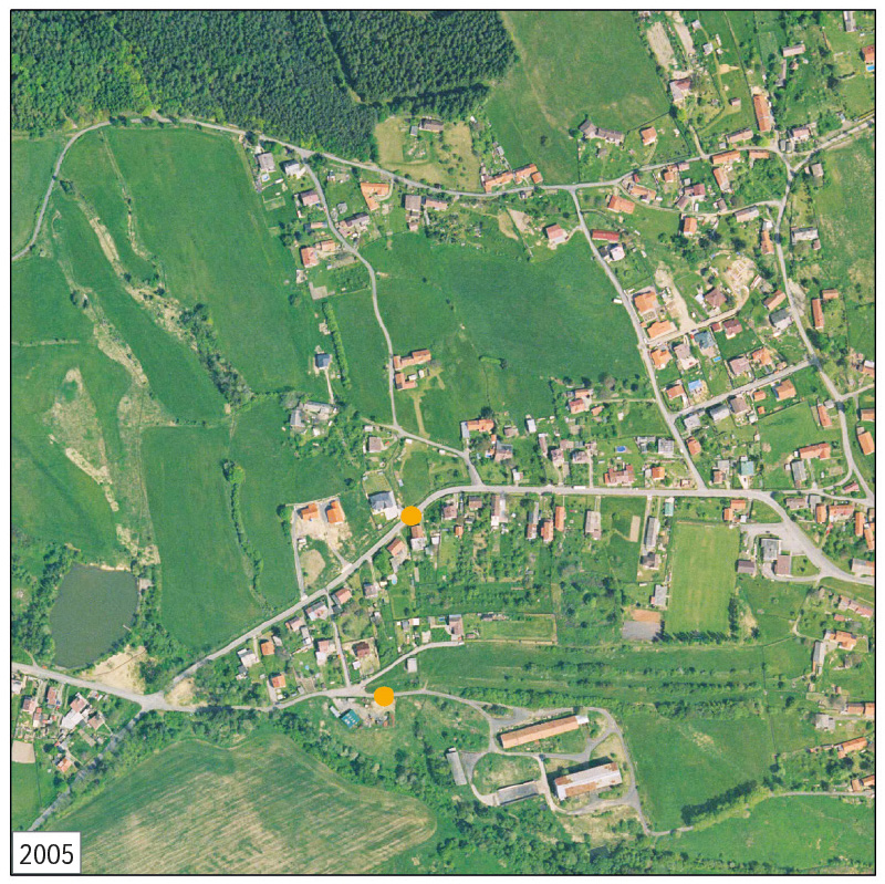
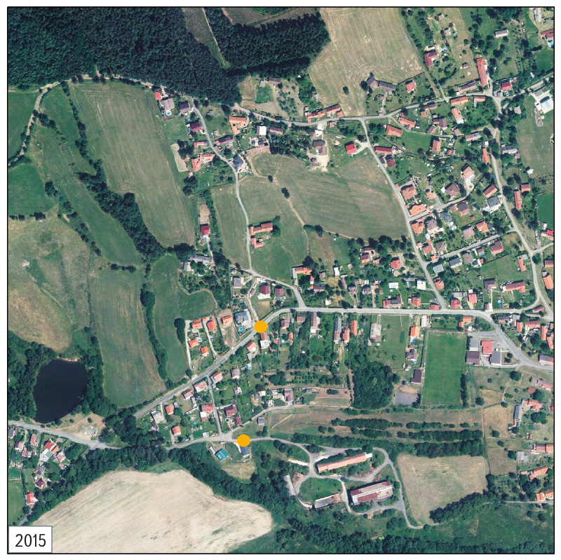
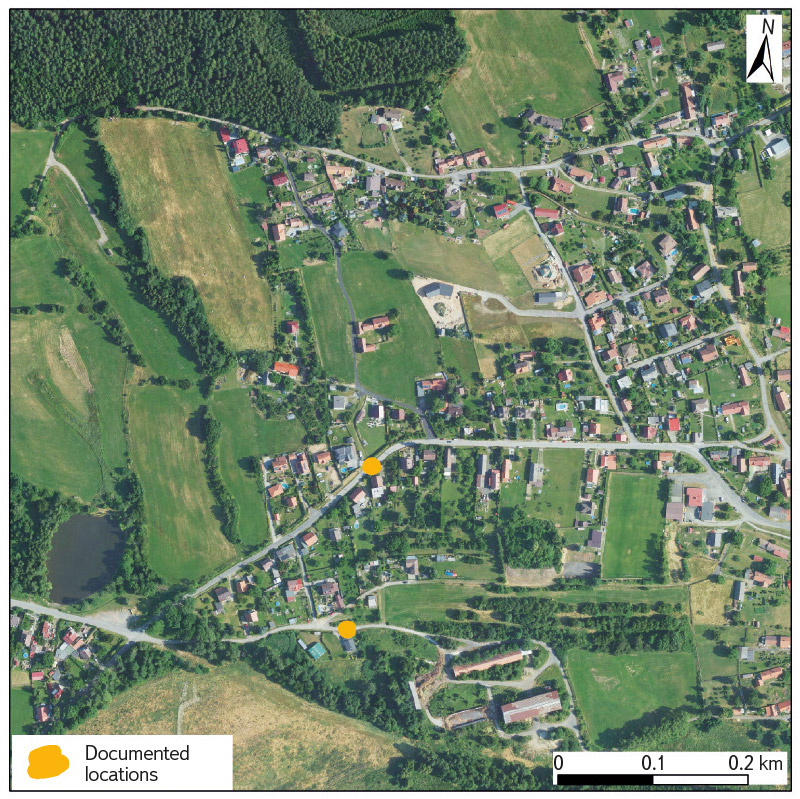
Fig. 8. Documented localities in Drahlín cadastral area in the context of landscape development on the Stable cadastre, Historical Orthophotomap from the 1950s, Archival Orthophotomaps from 2001, 2005 and 2015 and current Orthophotomap of the Czech Republic
Drahlínský stream in the Sádek cadastral area also caused temporary traffic inaccessibility of the municipalities of Sádek and Drahlín towards Lhota u Příbramě and Příbram, as water overflowed the road bridge. The situation on 2 June 2024, after the peak had subsided, compared to the usual state, is shown in Figs. 9 and 10. The location in the context of landscape development is shown in Fig. 11.
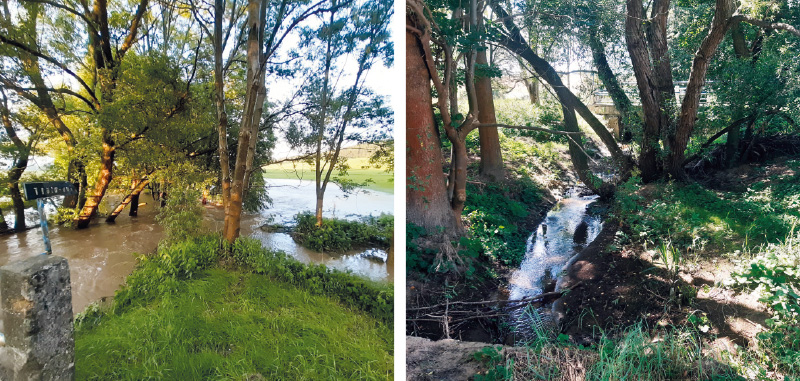
Fig. 9. Situation near the road bridge over Drahlínský stream during the flash flood in June 2024, compared to standard situation at the end of August of the same year
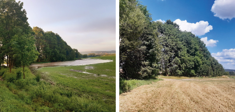
Fig. 10. Situation behind the road bridge over Drahlínský stream during the flash flood in June 2024, compared to standard situation at the end of August of the same year
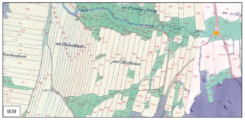
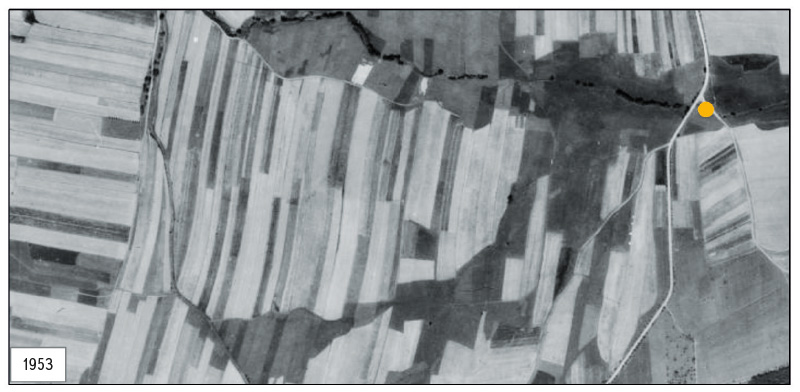
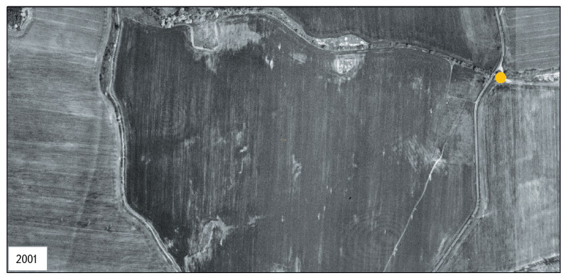
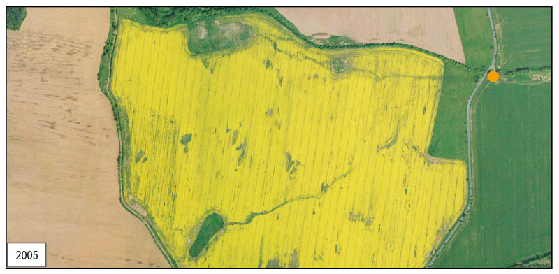
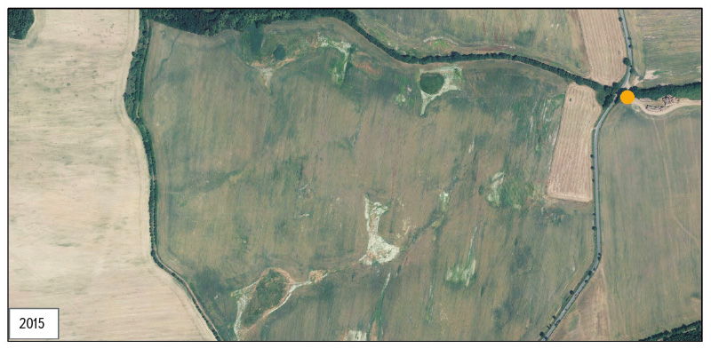
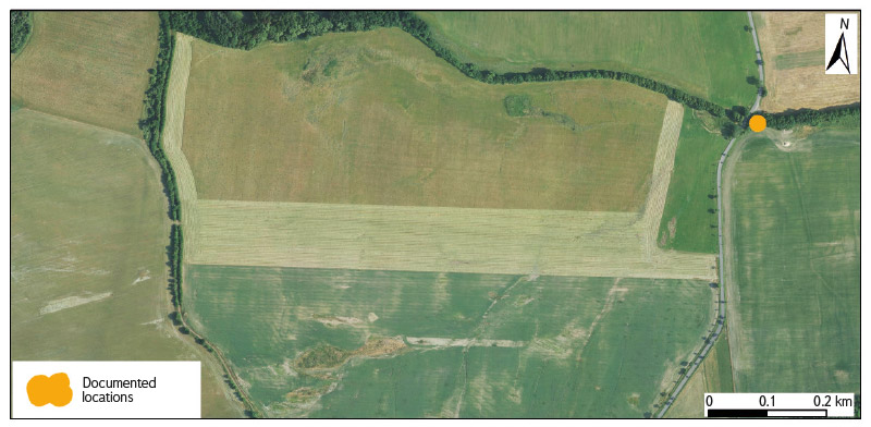
Fig. 11. Documented localities in Sádek cadastral area in the context of landscape development on the Stable cadastre, Historical Orthophotomap from the 1950s, Archival Orthophotomaps from 2001, 2005 and 2015 and current Orthophotomap of the Czech Republic
The forest stands were not able to contain these torrential rainfalls. Therefore, a field survey was carried out in this area as well. Since these forests were part of Brdy Military District until the end of 2015, there is a relatively dense network of paved roads and intensive forest management was also carried out here. A comparison of the area and condition of forest stands in the study area and its surroundings is shown on maps and orthophotomaps in Figs. 12 and 13, respectively. The current state of the forest, marked by the effects of erosion, is shown in Fig. 14.
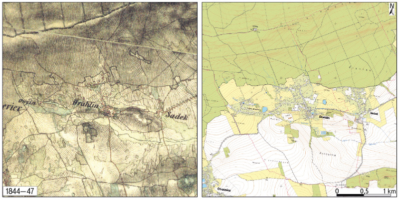
Fig. 12. Comparison of the forest stands state, including the surrounding landscape, shown on Map of the 2nd military mapping and on current ZTM 10
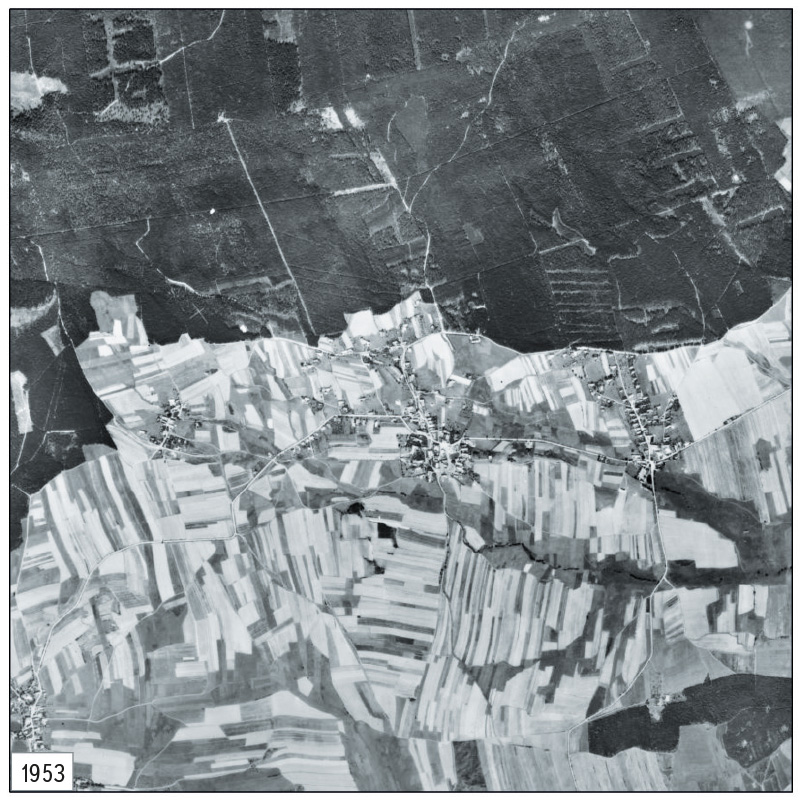
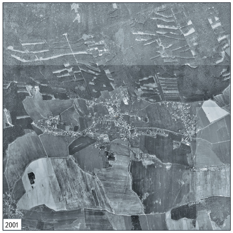
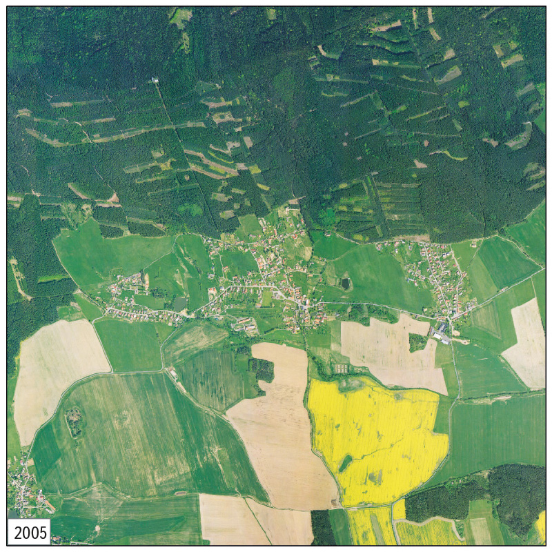
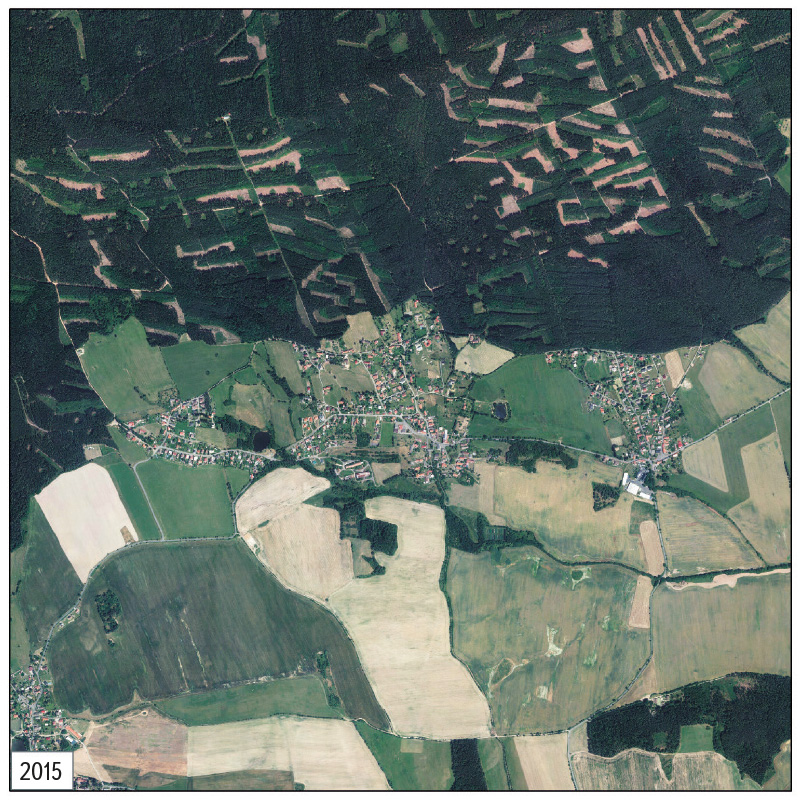
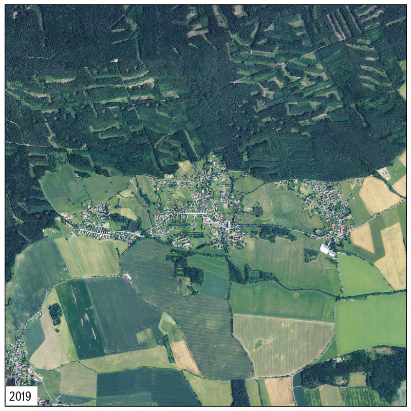
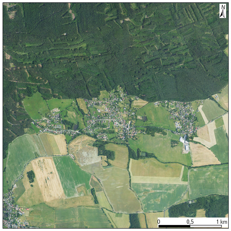
Fig. 13. Comparison of the forest stands state, including the surrounding landscape, shown on Historical Orthophotomap from the 1950s, Archival Orthophotomaps from 2001, 2005, 2015 and 2019 and current Orthophotomap of the Czech Republic
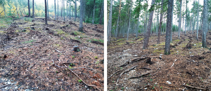
Fig. 14. The current state of the forest marked by the effects of erosion in Brdy PLA (October 2024)
Subsequently, publicly available hydrometeorological situation information in the weekly report archive on the CHMI website [15] were evaluated. Not all stations with recorded gauging are listed here, only selected ones. The closest such station to the study area is in Neumětely. In the Report No.: 22/Week: 27 May to 2 June 2024, this station reports a weekly precipitation total of 84 mm, which is 400 % of the normal with six rainy days per week. This is the highest weekly precipitation total of all the stations listed here and the second highest percentage of the normal after Doksany station (440 %). In the previous week (Report No.: 21/Week: 20 May to 26 May 2024), this station reported a weekly precipitation total of 14 mm, which is 83 % of the normal with five rainy days per week. In the following week (Report No.: 23/Week: 3 June to 9 June 2024), this station reported a weekly precipitation total of 4 mm, which is 24 % of the normal with one rainy day per week. Although weekly precipitation statistics can be misleading, as they do not consider the distribution or intensity of precipitation (or other quantities) on individual days, and Neumětely station is not in the immediate vicinity of the study area, these data can confirm the enormous amount of precipitation in Brdy PLA in the Příbram region, including Drahlín and Sádek municipalities.
DISCUSSION
Given the location of this June flash flood in the headwaters of Drahlínský stream in the immediate vicinity of Brdy PLA, it can be clearly concluded that this landscape cannot accommodate such an amount of torrential rainfall, especially after previous rainfall. At first glance, this is a landscape that has been relatively little altered by human activity. However, a comparison of maps (Figs. 8, 11, and 13) shows that significant changes have occurred in this location, with a negative impact on the retention and purity of water in the landscape. This mainly involved the gradual expansion of a built-up area into the original mosaic of dry and wet meadows and small fields, as well as the reduction of the historical road network, the straightening and piping of watercourses and the ploughing of their floodplains. The land reclamation of spring areas and their replacement with arable land also had an impact; in some locations, after the destruction of land reclamation structures, the original landscape cover was partially restored with the help of succession (Fig. 11).
Fig. 12 indicates that the area of forest stands has slightly expanded in the study area; however, the orthophotomaps in Fig. 13 clearly show that, due to intensive forest management, a large number of extensive clearings were created – this is most noticeable in the image from 2015. This was coincidentally the last year when this area was under the administration of the Military Forests and not under the Nature Conservation Agency of the Czech Republic (NCA CR).
A comparison of the development of the location of watercourses and water bodies in the area shows that both the largest ponds in Drahlín cadastral area were founded only after 1953. In addition to the straightening – and in some sections even the piping – of the Drahlínský stream and its tributaries, the designation of the main stream also changed. On the current ZTM 10 and ZTM 50, the section that originates above Malý Drahlín, in the eastern part of the municipality of Drahlín, is designated as the main flow (Figs. 2 and 12). On the Maps of the Stable Cadastre, the current – partially piped – left-sided tributary of the Drahlínský stream, which rises in the northern part of the area in the current Brdy PLA and flows along the Drahlín village square, is drawn as the main stream. The current spring section is not drawn here (however, a group of mostly wet but also dry meadows is shown, indicating a possible small stream or spring area). On the Maps of the Stable Cadastre, the Drahlínský stream is listed under the name “Potuczek” (Figs. 8 and 11). At the borders of the cadastral areas Drahlín and Sádek, the usual watercourse outline only passes into a small line and is then not drawn in the mosaic of wet meadows at all (Fig. 11). The Maps of Stable Cadastre are reliable; however, they have shortcomings in depicting small streams. In some locations where it is obvious that a small stream should be located (wet meadows are placed in the way that indicates a stream or a spring area), however, it is not there. Either it was a blanket spring area where no main stream existed, or some small streams were simply recorded only from a certain width [22, 23].
A comparison of precipitation totals in the week from 27 May to 2 June 2024 at Neumětely station and at other published stations with the week from 9 to 15 September 2024, when catastrophic floods occurred in a large area of the Czech Republic (especially in the Oder basin) clearly shows that from these data alone and without direct observation, the actual intensity of precipitation cannot be determined, and thus episodes leading to floods or flash floods cannot be indicated directly on individual days. Neumětely station itself reports a weekly precipitation total of 93 mm, which is 870 % of the normal with six rainy days per week. Compared to the week from 27 May to 2 June 2024, there was an increase of 9 mm, but in May, 84 mm was “only” 400 % of the normal with the same number of rainy days. The data from this week in September clearly confirms the extraordinary precipitation situation over almost the entire area of the Czech Republic; however, there was no flash or “standard” flood in the Drahlínský stream basin. The saturation of the area also has a significant impact on the amount of runoff in the basin. This is determined not only by precipitation, but also by the temperatures and evaporation in the previous period. When the affected area is significantly saturated, a large amount of water flows away during torrential rainfall not only from impervious surfaces, but also from other surfaces that would otherwise absorb at least a significant part of the rainfall. Before the flood in September 2024, the area was very slightly saturated and it rained for several days with less intensity than in June 2024. On the CHMI website [24], daily precipitation totals can be found at all (historical and currently gauging) meteorological stations; however, for current gauging stations, it is only until 31 December 2023 at present. The closest stations to the study area are Podlesí and Příbram. When the data are also available for 2024, it will be possible to describe in more detail the precipitation episode from the beginning of June in the municipalities of Drahlín and Sádek and compare it with the situation in mid-September.
So far, we have mentioned the freely available archive data managed by the CHMI on the precipitation situation in a given area within the Czech Republic. However, if citizens would like to actively monitor the risk of impending flash floods, they can use the Flash Flood Indicator operated by CHMI. It has been available to the public for several years now; it provides information on both the current area saturation and a potential precipitation (in one, three, and six hours) and calculates the current risk of flash flooding in our country every 15 minutes [25]. This shows both the risk of local flooding in 3 x 3 km grids and the risk of flash flooding on small streams. In the application, it is marked with a coloured flag, including the expected approximate time of culmination. The results of the calculation of the aggregate risk of flash floods are presented in a polygon layer of municipalities with extended powers (ORP), which are coloured according to the currently achieved maximum risk level. The calculated risk level always attributed to the entire ORP territorial district, even if only a smaller part of it may be affected. However, the Flash Flood Indicator application is operated only in the convective season (approximately April to October) and is available from the Flood Reporting and Forecasting Service website [26]. To monitor actual and expected precipitation, an application designed for detailed weather analysis and short-term precipitation forecasting (nowcasting) can also be used. This application displays, among other things, measured data (station gauging) and area-wide combined quantitative precipitation estimates (MERGE) [27]. Currently, a modernized version of MERGE2 is used, which allows updating the precipitation calculation every 10 minutes [28]. These websites only provide current data; archived data are available at the CHMI upon request.
CONCLUSION
In built-up areas, it would be desirable to pay more attention to issues with under-capacity piping and culverts and clogged or under-capacity channels of small watercourses.
It would also be appropriate to focus on landscape restoration in Drahlínský stream basin outside the PLA, especially on the restoration of wetland habitats in place of those that have disappeared, as the historical location of such elements is a very strong argument for their restoration (the designation of the NM/ESI Drahlínské louky can serve as an example of good practice). It is also necessary to restore the beds of small streams and restore their floodplains where possible. These landscape elements are also part of the solution to adapt to the issues caused by ongoing climate change. Their restoration should primarily lead to higher water retention in the landscape and an increase in landscape diversity.
This is in line with the EU Biodiversity Strategy to 2030 [29], which is a valid long-term plan for nature conservation, halting ecosystem degradation and restoring biodiversity in Europe. The Strategy recalls that biologically diverse ecosystems, such as wetlands as well as freshwater, forest, and agricultural ecosystems, when in good condition, provide a number of essential ecosystem services, and the benefits of restoring damaged ecosystems to good condition far outweigh the costs of their restoration. The EU Biodiversity Strategy for 2030 sets a commitment to legally protect at least 30 % of land and inland waters. The text also calls for greater efforts to restore freshwater ecosystems and natural river functions, including restoring at least 25,000 km of free-flowing rivers compared to 2020, when the EU Biodiversity Strategy for 2030 was adopted.
Hopefully, these will not be just declarations and the measures mentioned will actually be implemented in practice. In some parts of the Czech Republic, truly comprehensive changes are needed. Maybe it is not too late…
Acknowledgements
The article was created within the framework of the internal grant of the TGM WRI No. 3600. 23/2024 (Research support – institutional support, department 230).
The Czech version of this article was peer-reviewed, the English version was translated from the Czech original by Environmental Translation Ltd.
