ABSTRACT
In December 2020, the new EU Directive 2020/2184 on the quality of water intended for human consumption was published. This Directive places a strong emphasis on comprehensive protection of water resources and introduces an obligation to carry out risk assessment and risk management of the catchment areas for abstraction points of water intended for human consumption, compared to the previous Directive from 1998. The risk analysis of the catchment areas must be carried out for all water abstractions for drinking purposes that abstract more than 10 m3 raw water per day. In the Czech Republic, this concerns approximately 3,650 abstractions (of which about 3,500 are groundwater abstractions and about 150 surface water abstractions). On a nationwide scale, it is therefore a considerable amount of risk analyses of parts of the catchment areas, which, according to the Directive, must be performed by 2027. The main aim of the project “Tools for risk assessment of catchment areas for abstraction points of water intended for human consumption” (supported by the Technology Agency of the Czech Republic) is to develop a methodology for the preparation of this risk analysis of the catchment areas. In order to ensure that the risk analyses of the catchment areas to be prepared by different entities have a uniform form and structure, a form (mock-up) of what the risk analyses of the catchment areas should look like and what they should contain has been developed within the framework of the methodology. As this is a very complex issue, only the main skeleton of the methodology will be presented in this article, focusing on the basic characteristics of the abstraction and the definition of the area (the catchment areas) in which the risk activities for the quality of the abstracted raw water are determined.
INTRODUCTION
Protecting water resources is key to achieving good water quality and, at the same time, ensuring a sufficient amount of high-quality drinking water for human consumption. The European Union is also aware of this fact; in 2020, it issued the new European Directive EU 2020/2184 on the quality of water intended for human consumption [1]. One of the significant changes compared to the original directive from 1998 [2] is Article 8, which deals with the risk assessment and risk management of the catchment areas for abstraction points of water intended for human consumption. This risk analysis should then be followed by risk analyses of the water supply system processed according to Article 9 of EU Directive 2020/2184 [1].
The EU Drinking Water Directive [1] describes only the basic points and objectives of the risk analysis of the catchment areas. By 2023, each member state had an obligation to transpose the Directive requirements into its legislation based on the conditions of each country. In the Czech Republic, the ministries have agreed that these risk analyses will be part of the basin sub-plans, and therefore the Basin State Enterprises will have the obligation to develop them according to Annex No. 3 to Decree No. 50/2023 Coll. [3]. In Slovakia, all risk analyses will be developed by the Slovak Water Research Institute [4].
The main purpose of developing risk analyses of the catchment areas is the comprehensive protection of water resources in the natural environment, i.e. before the water is abstracted. It is important to identify potential risks in the catchment areas associated with water abstraction points intended for human consumption. Thanks to this identification, targeted measures can subsequently be proposed to mitigate these risks. Other objectives are to ensure proper monitoring of relevant parameters in raw water and to assess the need to establish new or adapt existing protection zones of valuable water resources.
The aim of the project TA CR No. SS05010210 “Tools for risk assessment of catchment areas for abstraction points of water intended for human consumption” is the creation of a methodological procedure for the development of risk analysis of the catchment areas.
METHODS
Risk analyses of the catchment areas will be developed for all abstractions in the Surová voda (Raw Water) database [5], for which at least one monitoring of parameters in raw water was reported in 2019–2023. The Surová voda database [5] is used for uploading and managing raw water quality data in the scope of complete and abbreviated analyses in accordance with the requirements of Decree No. 428/2001 Coll. [6], as amended. Access to the system (https://surovavoda.chmi.cz) is given to state administration bodies, sanitary stations, basin managers, water infrastructure operators, and laboratories authorized by these operators to upload the results of laboratory analyses into this system.
This time range was chosen because data in the Surová voda database [5] older than 2019 show a higher error rate. The final year will then be 2023, as more recent data will probably not be available during the processing of the first risk analyses of the catchment areas. According to EU Directive 2020/2184 [1], risk analyses of the catchment areas must be prepared no later than 12th July 2027, but given that according to Decree No. 50/2023 Coll. [3] the risk analyses will be part of the basin sub-plans, it is necessary to process them between 2025 and 2026.
According to EU Directive 2020/2184 [1], risk analyses of the catchment areas are to be regularly reviewed at least once every six years and subsequently updated if necessary. The next review will therefore be in 2032 at the latest.
A form (mock-up) was created for the uniform development of risk analyses of the catchment areas, describing both their form and content. Two types of forms were created, one for groundwater abstraction and one for surface water abstraction. These forms will be binding for the development of risk analyses of the catchment areas and are divided into five chapters:
- Basic abstraction characteristics
- Characterization of the catchment area related to the abstraction point
- Identification of potential risks in the catchment area related to abstraction points of water intended for human consumption
- Assessment of appropriate monitoring of relevant parameters in raw water and verification of potential risks
- Conclusion
In the following text, the basic characteristics of abstraction and definition of the area (catchment area) in which risk activities for the quality of sampled raw water are evaluated will be discussed in more detail.
Basic abstraction characteristics
The Basic abstraction characteristics chapter contains the most important data on the abstraction. The basic abstraction identifier is the abstraction identification number from the Surová voda database [5]. It is a unique eight-digit number. The basic data also include the name of the abstraction, number of structures analysed, whether it is a mixture from several raw water sources, type of abstraction, number and types of structures abstracted, category of the treatment plant, information on the basin manager and abstraction operator, abstraction size, and abstraction size category.
One of the most important basic data is the abstraction location; it is given in S-JTSK coordinates. It should be based both on the coordinates listed in the Surová voda database [5], as well as on the coordinates from the Evidence uživatelů vody database (Water User Records, EvUživ) [7] and on the coordinates of the first degree of protection zone for vulnerable water resources (OPVZ) [8]. If the location differs significantly according to the mentioned sources, the location according to the Surová voda database [5] and according to the EvUživ register [7] should always be indicated, but the information about the location in the relevant OPVZ [8] should primarily apply. At the same time, any discrepancy should be commented on. If it is not possible to find OPVZ [8] for an abstraction point for which the location in the Surová voda database [5] is significantly different from the location in EvUživ [7], the actual location cannot be identified without information from the water supplier.
Characterization of the catchment area related to the abstraction point
The second chapter in the form for processing the risk analysis of the catchment areas is characterization of the catchment areas related to the abstraction point. The basic characteristics for surface water abstraction include data on fourth order hydrological basin, surface water body, name of the watercourse, river kilometre and, for groundwater abstractions, data on the fourth order hydrological basin, groundwater body, and hydrogeological district.
Other important characteristics of the catchment areas include information on the protection zone for vulnerable water resources (OPVZ) for the given abstraction. OPVZ are updated annually in the OPVZ register, where documents establishing the OPVZ (decisions/measures of a general nature) are attached. Attribute information is attached to each OPVZ (date of definition, office, procedure number, municipality, region, source type, and others) [8]. This database, managed by the Ministry of the Environment and updated by TGM WRI, contains all OPVZ for which documents on their definition were found and which are registered in the Centrální registr vodoprávní evidence (Central Register of Water Rights Records, CRVE) [9]. If there is no document establishing OPVZ for a given abstraction, it is considered non-existent. However, it is necessary to verify this information with the local water authority (VPÚ). It may happen that the VPÚ or the water resource user did not submit the document to the OPVZ records.
Furthermore, for each abstraction, its inclusion in the relevant abstraction category must be carried out. Abstractions are first divided into groundwater and surface water abstraction. The risk analysis forms of the catchment areas differ for these two types of abstraction; also, some attributes are specific and set only for a certain type of abstraction. Surface water abstractions are then further divided into abstractions from reservoirs, abstractions from watercourses, and others (e.g. abstractions from a flooded gravel sandpit). The categorization of groundwater abstractions is more complex and is based on the division of groundwater abstractions into groups according to the natural characteristics of the abstracted water, focused on hydrogeological structures that are specific in terms of their time-space water flow regime. Based on this criterion, groundwater abstraction is divided into three basic groups: abstraction from deep structures, abstraction from fluvial Quaternary, and abstraction from the subsurface zone. Samples from deep structures include groundwater samples from Cretaceous and Tertiary basins, samples from karst and samples from glacial Quaternaries. Abstractions from the fluvial Quaternary include groundwater abstractions from Quaternary groundwater formations and also abstractions from floodplains. The last group is abstraction from the subsurface zone, including other abstractions. These are mainly abstractions from Crystalline and similar geological formations.
Another important step in the risk analysis of the catchment areas is the definition of the catchment area. Defining the catchment area is generally one of the key steps in risk analysis. This is because it is an area in which risk activities can potentially or actually affect the quality of the abstracted water. In other words, it defines a part of the territory on which the risk analysis of the catchment area will take place. Even though those preparing risk analyses of the catchment area should primarily be based on the OPVZ definition, they must first determine whether the OPVZ corresponds at least approximately to the catchment area. The catchment area should be specifically defined according to the category of abstraction.
RESULTS AND DISCUSSION
Using specific examples of abstractions, we will present how the definition of the catchment areas should be carried out for different categories of abstraction.
The catchment area for surface water abstraction is given by all fourth order hydrological basins located above the abstraction point. However, it is always important to consider the specifics of the given abstraction and, based on expert assessment, it is possible to reduce this area in the case of a very large catchment area (for example, on the basis of information on the use of the area, potential sources of pollution, and the distance from the abstraction). We regard groundwater abstractions from fluvial Quarternary in a similar way to abstractions from surface water; this is because, in addition to the inflowing groundwater, they also receive a greater or lesser amount of surface water from the watercourse. The share of surface water abstracted will vary based on the hydrological situation (at higher levels of surface water, groundwater may be recharged by water from the watercourse) and according to the amount of water abstracted (if more water is abstracted than groundwater inflow, surface water infiltration occurs). Since it is not easy to define for individual abstractions which part of the water abstracted is from groundwater and which from surface water, it is better to treat all of them as if they were surface water abstractions; this is because surface water is usually more vulnerable to anthropogenic pollution. The catchment area for groundwater abstractions from the fluvial Quaternary is therefore, similarly to surface water abstractions, defined by all fourth order hydrological basins above the abstraction point. Even in this case, it is possible to reduce a very large area based on the specifics of the given abstraction and expert assessment, similar to the case of surface water abstractions. An example is the abstraction of groundwater TS STRAKONICE Pracejovice (ID Surová voda: 11701200). It is an abstraction in the hydrogeological district of the Otava and Blanice Quarternary near the Otava river. The abstraction is defined by OPVZ of the first and second degree (Fig. 1).
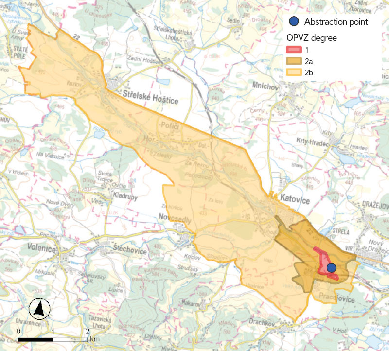
Fig. 1. TS STRAKONICE Pracejovice protection zones for vulnerable water resources (ID Surová voda: 11701200)
In the case of defining the catchment area for this abstraction, all fourth order hydrological basins of the Otava river above the abstraction point should be considered. This is a very large area; however, with the use of additional information (e.g. from CORINE Land Cover 2018 data) it is possible to reduce this area, as the Šumava PLA and the Šumava National Park are located in the southwest of the catchment area, where there are no major potential risks, such as arable land and larger settlements (Fig. 2).
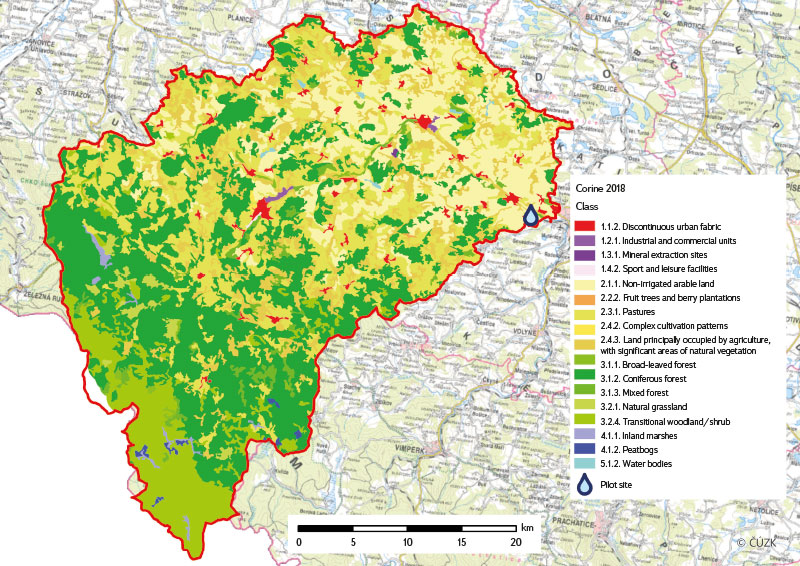
Fig. 2. Land use based on CORINE Land Cover 2018 data in the catchment area of groundwater abstraction TS STRAKONICE Pracejovice (ID Surová voda: 11701200)
Definition of the catchment area in the shallow near-surface Crystalline zone, which makes up about three-quarters of the Czech Republic, is relatively simple. As a first approximation, it is possible to use the fourth order basin in which the abstraction is located. However, the catchment area often does not include the entire basin – it is usually significantly smaller. On the one hand, the abstraction is rarely located near the fourth order basin closing profile, but on the other, it does not occur in the river floodplain, as in that case it would belong to the fluvial Quarternary. The catchment area can be estimated according to the contours of the terrain – the catchment area starts below the abstraction (this is because during the abstraction, a cone of depression of the groundwater level is formed and the groundwater is also pumped below the abstraction); the catchment area is further defined by perpendiculars to the contours up to the highest point. Such a definition of the catchment area can be seen in the example of the Dolní Niva abstraction (ID Surová voda: 32207000), where only the first degree of OPVZ is defined. The catchment area begins about 100 m below the abstraction point (which is probably much more than the distance of the actual cone of depression) and is defined from above by the Vysoká jedle summit (735.4 m a.s.l.) and elevation point 207 (726.9 m a.s.l.) (Fig. 3).
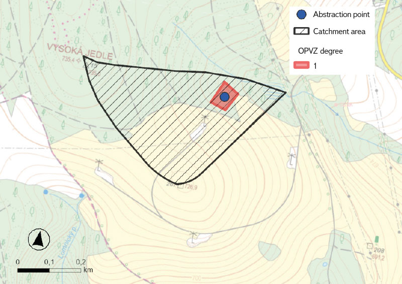
Fig. 3. Catchment area of groundwater abstraction Dolní Nivy (ID Surová voda: 32207000)
The most complicated catchment area definition is for abstractions of groundwater from deep structures. In the Czech Republic, this concerns the area of the Permocarbon basins, the Czech Cretaceous basin and both South Bohemian basins, the areas of Tertiary, flysch and Kulm in Moravia, and the Moravian Karst. However, the mere geographical situation of collection structure in the space where the deep structure occurs does not necessarily mean that the deep structure is actually used. Depending on the depth of the abstraction object, the case can occur where a shallow collection structure uses only the subsurface zone. The issue of defining the catchment area is the most difficult in structural basins, where in the extreme variant the abstracted groundwater can come from several aquifers of mutually different, often large areas. In addition, these aquifers are covered on some areas or separated from each other by an impermeable insulating layer, which protects the respective aquifers from contamination from the surface. The automatic application of the fourth-order hydrological basin for the definition of the catchment area in the subsurface zone environment would therefore in most cases give a distorted picture.
According to the degree of exploration of the given hydrogeological district, we can divide the methodological procedures for defining the catchment area for abstraction from deep structures into four variants. Here are examples of defining the catchment area according to these methodological procedures.
1) Defining the catchment area by a hydrogeologist on the basis of a hydraulic model
The absolutely ideal and most accurate solution is to consult a hydrogeologist who works in the given district and knows the infiltration areas of the respective aquifer. If a hydraulic model of groundwater flow is available in a given district, then it is possible to define the infiltration space for individual aquifers using GIS tools, used in the construction of the model geometry and its calibration. These data quite precisely define the environment on which the risk analysis should focus.
This case was tested at the abstraction of ČEVAK Suchdol n/Lužnicí (ID Surová voda: 11300600). It is a complicated case of the Cretaceous Klikov formation abstraction in the Třeboň basin. The collection structure connects several dozen sandy aquifers, which are separated from each other by clay insulators or sandy-clay semi-insulators. The catchment area was defined on the basis of the infiltration area used in the 3D hydraulic model of the company Progeo, s. r. o., which considered the direction of groundwater flow in the basin system to the abstraction point in the final form; see Fig. 4.
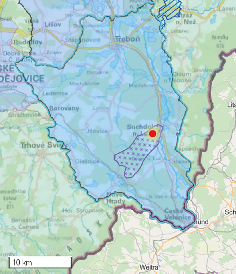
Fig. 4. Catchment area (purple marked area) of groundwater abstraction ČEVAK Suchdol n/Lužnicí (ID Surová voda: 11300600) on the basis of the Progeo, s. r. o., hydraulic model and its inclusion in the broader context of the relevant hydrogeological region Třeboňská pánev – jižní část (blue highlighted area)
2) Defining the catchment area based on documents from the “Rebalancing of groundwater supplies” project
Consultation with a hydrogeologist may not always be possible for various reasons. Therefore, two alternative variants are offered, which bring with them the risk of simplification, and therefore also the possibility of introducing inaccuracies. The first option, which still provides a relatively high degree of credibility, is the use of information from the “Rebalancing of groundwater supplies” project [10], implemented by the Czech Geological Survey. It covers most of the major structural basins.
An example of an abstraction where it is possible to use information from the “Rebalancing of groundwater supplies” project is the abstraction of SčVK Dubnice pod Ralskem (ID Surová voda: 33045800), which is located in hydrogeological district 4640 – Cretaceous upper Ploučnice. According to the decision of the Česká Lípa District Office, the environment department from 1997, this abstraction is limited only to the first degree of OPVZ with dimensions of 20 × 20 metres. The database of geologically documented structures, which can be accessed using the Vrtná prozkoumanost (Drill Exploration) map application [11] and which is maintained and managed by the Czech Geological Survey, shows that the abstraction of SčVK Dubnice pod Ralskem (ID Surová voda: 33045800) is 400 metres deep and abstracts the Coniacian aquifer. It is therefore evident that it is a collection structure of deep circulation, without the influence of the near-surface zone. Such a deep hydrogeological well always has a technically sealed upper zone. It is therefore possible to use the information from the Final Report of the “Rebalancing of groundwater supplies” project for hydrogeological district 4640 – Cretaceous upper Ploučnice [12] when defining the catchment area. This report shows that there are three significant hydrogeological aquifers in the district at different depth levels: aquifer A (Peruc–Korycany formations of Cenomanian age); above it, aquifer BC (Bílá Hora and Jizera formations of lower to upper Turonian age); and in part of the district, aquifers D (Teplice and Březno formations of Upper Turonian to Coniacian age). The abstraction of SčVK Dubnice pod Ralskem (ID Surová voda: 33045800) abstracts the uppermost aquifer D, which is developed in the northwestern part of the district in the form of several more or less independent bodies. The base of aquifer D generally dips from north to south and is often interrupted by vertical tectonic displacements. The chapter on the definition of infiltration areas shows that the occurrences of aquifer D are divided by erosional valleys into several balance-independent water subsystems with infiltration in the areas of their occurrences and with drainage of groundwater into the surrounding watercourses – especially into Ploučnice with its tributaries. The water level is mostly open. Aquifer D is fed by precipitation infiltration throughout the area of occurrence, except for areas covered by loess, where infiltration is considerably limited. Based on the above findings, it can be stated that the catchment area for the abstraction of SčVK Dubnice pod Ralskem (ID Surová voda: 33045800) will be defined by the basins of the Dubnický and Ještědský streams. It is obvious that the quality of the abstracted water will not be actually affected by the entire defined area. A limiting role will be played by insulating surfaces formed by loess, as well as by tectonics extending in the direction of drainage. However, the inclusion of the entire Dubnický and Ještědský stream basins is an optimal compromise on the side of precautionary risk.
3) Defining the catchment area in an environment that is not covered by the “Rebalancing of groundwater supplies” project, but has a defined credible second-degree protection zone for vulnerable water resources
This method of defining the catchment area is burdened with a greater degree of uncertainty and is also more time-consuming. An example is the definition of the catchment area for abstraction of SčVK Holedeč vrty (ID Surová voda: 33070200). There is no information about this resource regarding its technical parameters. The only data that can help is the decision of the environment department of the District Office in Louny from 1991, which establishes the first and second degree of OPVZ. This decision talks about eleven collection structures, but without mentioning their names according to which they could be identified, or compared to the wells in the Vrtná prozkoumanost map application [11]. Therefore, it was necessary to turn to a different procedure. It can be assumed that the first degree of the OPVZ is in the immediate vicinity of the collection structures, and thus an appropriate selection can be made using the Vrtná prozkoumanost map application [11]. The wells located inside the first degree of the OPVZ have a depth of 100 metres and abstract a Neogene aquifer. Since no further information is available for the given site, with some uncertainty, it is possible to consider the extent of the second degree of the OPVZ defined in the aforementioned decision as the catchment area (Fig. 5). In this case, this consideration can be based on the legitimate assumption that this zone was created on the basis of a previous detailed hydrogeological assessment, which considered the directions of groundwater flow from the infiltration area towards the abstraction point.
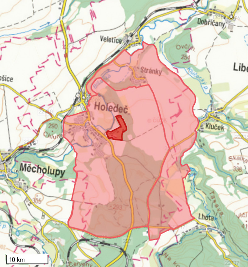
Fig. 5. Catchment area of groundwater abstraction SčVK Holedeč vrty
(ID Surová voda: 33070200) based on the protection zone for vulnerable water resources
4) Defining the catchment area in an environment that is not covered by the “Rebalancing of groundwater supplies” project and does not have a defined second-degree protection zone for vulnerable water resources
The most difficult variant, burdened with the greatest uncertainty and, in the extreme variant, even without the possibility of defining the catchment area, is the case where the abstraction object:
- lies in a structure that falls into the deep structure category,
- this area is not covered by the “Rebalancing of groundwater supplies” project [10],
- does not have a defined second degree OPVZ,
- there are no technical parameters on the method of abstraction. The depth of the boreholes/wells, their number or their designation, i.e. the parameters that would enable the structure identification in the Vrtná prozkoumanost map application [11], are not known.
The only and most time-consuming procedure is to try to find at least part of the missing data and proceed to define the catchment area in the same way as a hydrogeologist processes a second degree OPVZ proposal. It should be emphasized that, based on our experience, this case is rather exceptional; however, we must mention it for the purpose of objectivity.
CONCLUSION
The main purpose of developing a risk analysis of the catchment areas is the comprehensive protection of water resources. It is important to identify potential risks in the catchment areas associated with water abstraction points intended for human consumption. However, for this, it is necessary to know the extent of the catchment area, which does not always correspond to the OPVZ. Thanks to the identification of potential risks and verification based on monitoring, targeted measures to mitigate potential risks should be proposed. Therefore, proper monitoring of relevant parameters in raw water and assessment of the need to establish new or adapt existing OPVZ must be ensured. For uniform processing of risk analyses of the catchment areas, a form was created with a precise structure, which should be followed by the processors of risk analyses of the catchment areas. The form has five basic chapters and clearly summarizes what should be part of the risk analysis of the catchment areas. This article is focused on the basic characteristics of the abstraction and the catchment area, which are one of the most important steps in the risk analysis processing. A high-quality risk analysis of the catchment areas cannot be developed without the correct definition of the catchment area.
Acknowledgements
The article was created within the framework of the Technological Agency of the Czech Republic project No. SS05010210 “Tools for risk assessment of catchment areas for abstraction points of water intended for human consumption”.
The Czech version of this article was peer-reviewed, the English version was translated from the Czech original by Environmental Translation Ltd.
