ABSTRACT
The article presents a project from the Technology Agency of the Czech Republic dealing with the hydrogeology of old waters in hydrogeological regions 4410 and 4522. The aim of the paper is to present a brief hydrogeological characterization of the area of interest, to present the results after the first year of the project, and to describe the uncertainties of existing information. Old groundwaters that have negligible concentrations of tritium can be considered a strategic resource because they are less susceptible to current contamination. In order to quantify the usable amount of these waters, discharge from springs with low tritium concentrations is measured regularly. At the same time, water samples have been taken from the most important water supply facilities in the area. The chemical composition and tritium activity of these waters have been determined and physico-chemical parameters measured. On the basis of known groundwater level patterns, lithology and measured values, a conceptual model of the flow pattern of this old water was outlined, which will be further verified and supplemented during the project using the newly acquired knowledge. Due to the relatively low electrical conductivity of the old groundwater, it is expected that the water would have infiltrated in areas where there are no outcrops of calcareous sandstones, as bicarbonates would increase the conductivity significantly. For this reason, we assume that the water infiltrates near Bezděz, where there are outcrops of quartz sandstone. From there, the water flows to springs and water collecting facilities, where, especially in the lower parts closer to the drainage areas (the Jizera and Elbe rivers), it can be further mixed with outflow from the Cenomanian aquifer. Nevertheless, there are places in the area that are not fully consistent with this assumption, and the origin of these groundwaters is also the subject of further research. The next phase of the project will focus on a detailed analysis of the age of the waters using other tracers, such as CFC or SF6. This information will lead to a better understanding of groundwater flow in the most important hydrogeological structure in the Czech Republic.
INTRODUCTION
The Czech Republic is relatively rich in groundwater resources. Most of the collected water has a short circulation time (typically just a few decades). In the event of a potential large-scale catastrophic event, these shallow water supply resources cannot be used to supply drinking or commercial water.
Fossil waters, cut off from the current hydrologic cycle, are usually of low quality and limited supply because they are not recharged. However, in part of the Czech Cretaceous Basin there are also actively flowing waters with a residence time of at least 70 years and in some cases significantly more, as described in the project “Rebilance zásob podzemních vod (Rebalancing of groundwater supplies)” [1, 2]. We continue to call these waters with a relatively longer mean residence time “old waters” in the paper. Namely, there are two Cretaceous hydrogeological regions (HGR): HGR 4410 Cretaceous of the Jizera river, right-bank part; and HGR 4522 Cretaceous of the Liběchovka and Pšovka streams.
This article describes the study of hydrogeological issues of these parts of the Czech Cretaceous Basin as part of project No. SS06010268 “Poznání, kvantifikace a ochrana strategických zdrojů podzemní vody české křídové pánve hlubokého oběhu v hydrogeologických rajonech 4410 a 4522 (Identification, quantification and protection of strategic deep-flow groundwater resources in the Bohemian Cretaceous Basin, in hydrogeological regions 4410 and 4522)”.
As part of the project, the area will be described in detail from a hydrogeological point of view. There is a relatively small amount of information about these waters – often expert estimates that need to be verified. Although it is a significant accumulation of high-quality groundwater (the area includes, for example, the important water supply facilities of Řepín and Bělá), the tritium analyses so far only come from a few springs. Uncertainties also surround the usable amount of these waters and the place of their infiltration. The aim of the project is to remove and resolve these uncertainties. In the current phase, available literature and data sources are collected about the area of interest, and field data collection and sampling are being carried out for hydrochemical and tritium groundwater analyses (already underway or completed). The aim of the article is to provide a brief hydrogeological description of the area of interest based on a literature search, to present partial results from discharge measurement and sampling and to describe the current uncertainties of existing information.
AREA DESCRIPTION AND METHODOLOGY
In order to obtain a comprehensive picture of the current state of knowledge about the area of interest, available relevant information sources have been collected. These are stratigraphic correlation sections, hydraulic models of groundwater flow, hydrochemical analyses, and groundwater dating results. In the research part, we present the basic concept of groundwater flow formulated in the previous project “Rebilance zásob podzemních vod (Rebalancing of groundwater supplies)” [1, 2], which will subsequently be verified, critically evaluated, supplemented, or changed as part of the project – with the use of newly acquired data and knowledge.
On the basis of a literature search, archival data of tritium analyses [1–3] and thermometry measurements [4], objects of interest (springs, boreholes) were selected for sampling and monitoring (hydrochemical analyses, dating techniques, discharge).
Basic geological and hydrogeological characteristics of the area of interest
This section describes the basic geology and hydrogeology of the area of interest (Fig. 1). The area falls partly into HGR 4410 (Cretaceous of the Jizera river, right-bank part), which forms a transitional facies between the mostly sandy development WNW of the Jizera and the predominantly clayey development ESE of the Jizera. There is a significant occurrence of calcareous and quartz sandstones of the Middle to Upper Turonian of the Jizera Formation [5, 6]. The second HGR in the area is 4522 (Cretaceous of the Liběchovka and Pšovka streams), which is also the most hydrogeologically significant aquifer of the Jizera Formation, which thickens upwards from calcareous siltstones and marlstones to coarse-grained quartz sandstones with conglomerates [2]. The third HGR in the area is 4720 Cretaceous basal aquifer between Hamr and the Elbe river valley. From a hydrogeological point of view, however, it does not have to be an isolated region and outflow can occur from the upper regions to the lower region and vice versa through aquitard or aquicludes [7].
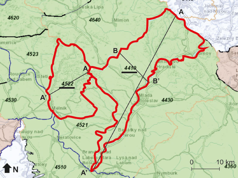
Fig. 1. Map of the area of interest showing the two hydrogeological regions (red borders). The map shows the cross sections (thin black lines) depicted in Figs. 5 and 6. Adapted from mapy.geology.cz
In the area of interest, the Peruc–Korycany Formation, Bílá Hora, Jizera, Teplice Formations and Rohatec Strata are divided from lithostratigraphic point of view (from the oldest), ranging in age from the Cenomanian to the Coniacian. Younger Cretaceous assemblages have not been preserved. The stratigraphy of the area of interest in HGR 4410 in a section from NW (Bezděz) to SE (Mladá Boleslav, Jizera) is clearly shown in Fig. 2, which shows the stratigraphic scheme according to lithostratigraphy (formation), chronostratigraphy (age), and genetic stratigraphy [8]. In Fig. 2, aquifers A (Cenomanian) and C (Turonian) are also defined, with a division into sub- aquifers Ca and Cb (in some studies, sub-aquifer Cc is also mentioned [1, 4]). The stratigraphy in HGR 4522 is clearly shown by the section from S to N in Fig. 3.
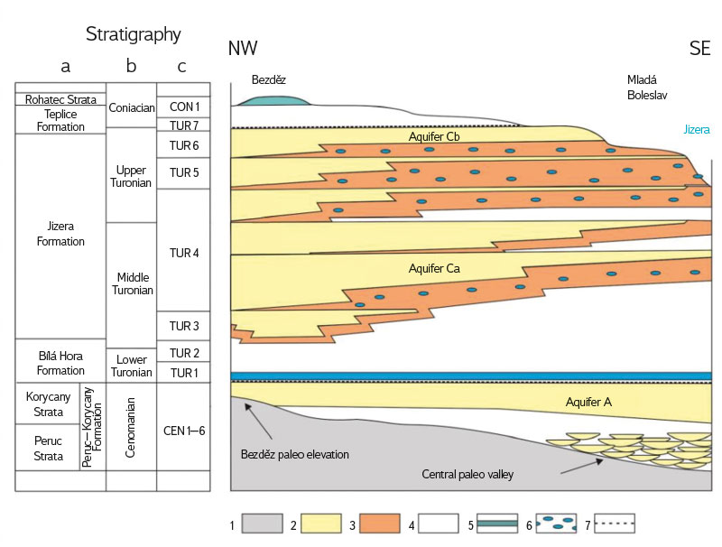
Fig. 2. Stratigraphy and aquifers of region 4410. 1 – Cretaceous bedrock; 2 – Quartz sandstone; 3 – Calcareous sandstone; 4 – Marlstone, siltstone, claystone; 5 – Micrite limestone; 6 – Concretion limestone; 7 – Glauconite-phosphate horizon; a – lithostratigraphy [9]; b – chronostratigraphy; c – genetic stratigraphy [8]. Modified after [1]
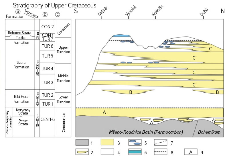
Fig. 3. Stratigraphy and aquifers of region 4522. 1 – Cretaceous bedrock; 2 – Fluvial channel sandstone; 3 – Sandstone; 4 – Marlstone, siltstone, claystone; 5 – Limestone; 6 – Silicified claystones; 7 – Tectonic zones; 8 – Glauconite-phosphate horizon; 9 – Aquifers. a – lithostratigraphy [9]; b – genetic stratigraphy [8]; c – chronostratigraphy. Modified after [2]
The Peruc–Korycany Formation (Middle to Upper Cenomanian) is not lithologically homogeneous and represents clastic sediments of fluvial, estuarine, and marine sedimentation regimes. From a hydrogeological point of view, marine quartz sandstones are important, which form here a basal aquifer referred to as A. It is mostly a confined aquifer that comes to the surface only in a narrow strip along the Lusatian fault. Water infiltrates into it either directly through surface rock outcrops, or through outflow from upper aquifers. The general direction of water flow is from the Lusatian fault SSW to the Elbe, where the water drains. The thickness of the formation is variable; around Bezděz, it is 10–15 m, and increases towards the N and SE.
The Bílá Hora Formation (Lower to Middle Turonian, genetic stratigraphy TUR1 and TUR2) was defined as a pelitic interval (marlstone, silty marlstone, calcareous claystone) in HGR 4410 with a thickness of 80–120 m as part of the project “Rebilance zásob podzemních vod (Rebalancing of groundwater supplies)”. The pelites are interpreted as a hydrogeological aquitard A/C [9]. In HGR 4522, the Bílá Hora Formation consists mainly of marlstone, in N calcareous siltstones to siltstones; it outcrops to the surface only in the Liběchovka valley in the NW of HGR 4522 [2].
The boundary between the Bílá Hora and overlying Jizera Formations is conventionally placed at the level of the first occurrence of calcareous sandstones with positions of concretionary limestones. The Jizera Formation (Middle to Upper Turonian, TUR3 to TUR6) is developed in the area of interest mainly in quartz sandstones and clayey-calcareous sandstones; it is the most widespread and represents a very important aquifer referred to as aquifer C. However, it is relatively split and forms several progradation cycles TUR3 to TUR6, divided into sub-aquifers Ca, Cb, Cc [8]. This splitting is more evident in the E, while on the W of HGR 4410, the Jizera Formation is formed throughout its thickness almost exclusively by quartz sandstones of aquifer C (Fig. 2). On the border with HGR 4521 (in the SW area), in the lower part of aquifer C (below TUR3), in HGR 4410, an anomalous development of two to three sharply limited layers of coarse-grained sandstones with a thickness of 10–30 m occurs, which increases the total thickness of the aquifer by up to 50 m. This is a unique phenomenon within the entire basin. The TUR5 base has elevated carbonate contents and forms a regional aquitard within aquifer C, with perched aquifers forming in places above the aquitard. The total thickness of the Jizera Formation in the SW part of HGR 4410 is around 200 m, it gradually decreases to the NNE. In HGR 4522, in the lower 80 m there is a Jizera Formation in aleuropelitic development referred to as aquitard A/C; towards the north, this thickness decreases to 10 m, and gradually the thickness of quartz sandstones increases. In the spring area of Liběchovka, the thickness of the Jizera Formation is 170 m [2].
The Teplice Formation (Upper Turonian to Coniacian) in isolated occurrences overlies the Jizera Formation in relics near Bukovno, Bezděz, and Bakov nad Jizerou. In HGR 4410, they form dark grey calcareous claystones up to 25 m thick. In the upper Pojizeří, no Rohatec Strata have been recorded; in the vicinity of Bezděz there are clayey sediments referred to as the Teplice and Březno Formations undivided. In HGR 4522, the Teplice Formation consists of very limited siltstone and calcareous siltstone relics.
Tectonic deformation of the area is minimal, with the exception of the N part near the Lusatian fault. In general, the Cretaceous layers are affected by by NW-SE, NNE-SSW to NE-SW fault systems. In the area south of Dubá and in the vicinity of Houska, there is probably a fault break into several separate blocks. The western part of HGR 4410 is deposited almost subhorizontally, towards the E with a transition to a Cretaceous block slightly tilted to the E and SE. Isolated bodies of alkaline volcanics penetrate through the sediments, e.g. Malý and Velký Bezděz.
There are two important aquifers in the area of interest: aquifer A (Peruc–Korycany Formation) and aquifer C (Jizera Formation, divided into Ca, Cb, Cc). Locally, in the valley of the Strenický stream, there is also aquifer BC, passing laterally into the aquitard.
From a water management point of view, the most important aquifer is C, connected to the sandstone of the Jizera Formation, covering almost the entire area of HGR 4410, with the exception of its NW and S edges. The water-bearing capacity of aquifer C is highest in the W part (170–190 m) and decreases towards the edges of HGR 4410. The permeability of the aquifer is provided by both pores and fissures, and it generally decreases towards E [1].
However, based on current knowledge, the mere division into aquifer A and C and aquitard B may be too simplistic [8]. For example, in the eastern part of HGR 4410, aquifer C is actually divided by siltstones and limestones into at least two to three sub-aquifers (Ca, Cb, Cc [1, 8]), while the basal artesian sub-aquifer Ca is in contact with the surface only by boreholes or insignificant leaks in the confining layer, while the middle sub-aquifer Cb has an open surface and drains to surface watercourses. Sub-aquifer Cc has discontinuous water-bearing and is a perched aquifer. This rather complex situation is manifested, for example, by the fact that on the right bank of the Jizera there is a different groundwater level depending on the depth of the boreholes, although in all cases it is “aquifer C”. Shallow boreholes (up to 50 m) up to the sequence TUR5 and TUR6 (sub-aquifer Cb) have levels close to the surface, connected to the Quaternary aquifer of the Jizera terraces. In contrast, deep boreholes (100–150 m) into TUR4 (sub-aquifer Ca) show levels 5–7 m above shallow boreholes. Although the majority of the groundwater circulation is probably linked to aquifer Cb, in the southern part of HGR 4410 the flow is significant only in TUR4 [1]. This considerable spatial variability must therefore be considered and distinguished when we speak of “aquifer C”. In addition, the schematic geological sections in Figs. 2 and 3 indicate that aquifer C is divided into 5–7 sandstone layers, so these sub-aquifers may often be even more than three.
According to archival tritium analyses [1–3], waters with low tritium activity can be found mainly in the southern part of HGR 4410 (south of Bělá), both in springs and in boreholes. Springs in the Strenický stream basin had values below 2 TU, with boreholes below 1 TU. In the Bělá basin, low values of tritium were detected in the vicinity of the Bělá paper mills (2.7 TU), Mukařov, and Mnichovo Hradiště (below 4 TU). Based on these values (considering the time of measurement around 2014 and the gradual decay of tritium), these objects of interest have a mixture of new water and water which infiltrated before 1950. In general, these objects of interest are mainly in the Strenický stream basin (total discharge about 150 l/s) and Bělá (about 50 l/s). Conversely, higher values of tritium activity (5–7 TU) are common for springs in the N and W parts of the district, but also occur in the Bělá basin.
In HGR 4522 in the Liběchovka basin, according to archival analyses, tritium activity was very variable (from 0.9 to 9.2 TU) but unrelated to the position in the basin. In the vicinity of Nedamov, on the upper Liběchovka, low tritium activity was detected in springs (below 4 TU). A spring with a lower value of tritium activity is also located in the lower Liběchovka in Liběchov (Boží voda). In the upper part of the Pšovka basin, tritium activity in springs was around 4–6 TU. However, Stříbrník spring had low tritium activity (> 10 l/s; 2.8 TU). Some collection boreholes in the upper part of Řepínský důl had lower activity as well [2, 3]. In this district, some objects of interest showed a considerable mean residence time, with the predominance of water which infiltrated before 1950. According to archival isolated analyses using other environmental tracers (radiocarbon, CFCs, SF6), the average residence time of waters in the area of the upper Liběchovka and Pšovka ranges from tens of years to over 100 years. The total discharge of long-circulating water in the entire area of interest was estimated to be at least 250 l/s [2].
Measurement of physico-chemical parameters and sampling for tritium analyses
In order to verify discharge of the old waters, 11 samples were taken for tritium analysis in 2023 from the monitored profiles at the springs, Strenický stream, and from other springs. In 2024, the largest catchment areas were sampled. In cooperation with VaK Mladá Boleslav, all collection boreholes with a higher discharge in the Bělá basin (11 samples) were taken. These boreholes take in a total of about 140 l/s and at least part of the water is probably old water due to the low mineralization and exceptionally good quality. In cooperation with Kladno – Mělník Waterworks, all active boreholes in the Řepínský důl catchment area (41 samples) were sampled. Total discharge is around 300 l/s, and older studies show that in some objects of interest it could be old water [1, 2]. For all sampled objects of interest, physico-chemical parameters of the water were measured in the field in a flow cell without contact with the atmosphere – conductivity, temperature, pH, oxidation-reduction potential, and dissolved oxygen concentration. The chemical composition of part of the samples was analysed. Samples for tritium activity are currently being analysed. The monitored objects of interest are shown in Fig. 4.
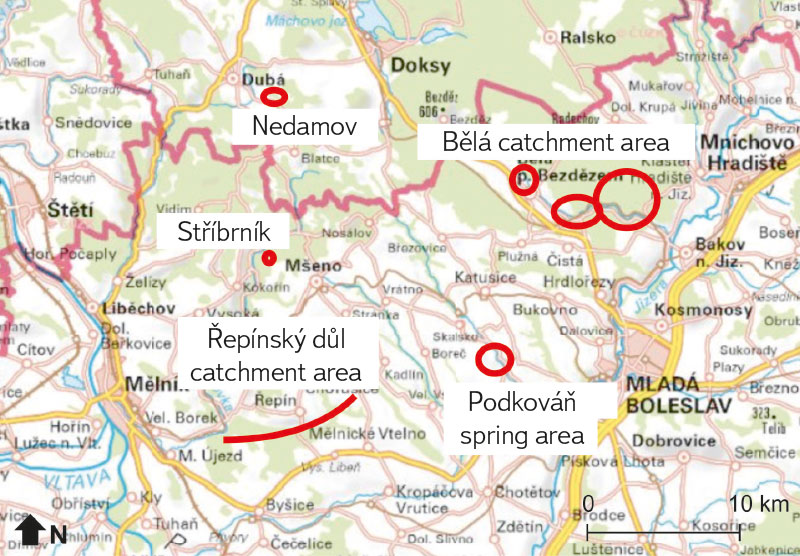
Fig. 4. Map of monitored sites (Based on cuzk.cz)
Discharge measurement
During the first six months of the project, ten locations for discharge monitoring were selected on the basis of archival data on tritium concentrations. These locations represent springs with low tritium activity, and are therefore older, and two profiles on the Strenický stream, which define an intermediate section recharged exclusively by springs with low tritium activity. Discharge was measured at roughly monthly intervals, either by the dilution method using NaCl with automatic recording of conductivity from the used WTW conductometers, or by calculation from the filling time of a vessel of a known volume. The first monitoring location is on the Strenický stream in Krnsko before the confluence with the Jizera. Strenický stream is mostly recharged by baseflow from the deeper zones of aquifer C, or B, and its flow is relatively constant over time. It is the main stream draining the area with springs with lengthy mean residence time based on older tritium activity analyses. During monitoring, discharge is measured using the dilution method with NaCl.
The second location is the Strenický stream near the village of Cetno, which is located above two springs with a low concentration of tritium. Here, discharge is measured using the dilution method. The third location is the outlet from the waterworks near the village of Cetno. According to previous analyses, this water also has low tritium activity. The flow here is measured by the dilution method. The fourth location is spring PP0230, currently monitored by CHMI in the village of Podkováň. This spring is one of the abundant sources at the Podkováň spring area with low tritium activity. Spring area discharge reaches 100 l/s at higher levels. Discharge here is calculated from the time it takes to fill a container of a known volume. The fifth location is the Strenický stream above Podkováň spring area. Knowing the flow of the Strenický stream above and below the spring areas (the difference in discharge from locations 1 and 5), it is possible to determine the total discharge of waters with a low concentration of tritium in the Strenický stream. Here, discharge is measured using the dilution method. The sixth location is Velký spring in Podkováň spring area. It is the most abundant resource in the spring area. There is a historical CHMI measuring weir (monitored in the past as PP00229) which, however, is no longer monitored by the CHMI. As part of the project, discharge here is measured using the dilution method.
The seventh site is located by the Rokytka watercourse near Bělá pod Bezdězem. It is an area with an abundance of springs, one of which – the Klokočka – has very low tritium activity. Discharge here is calculated from the time it takes to fill a container of a known volume. The eighth location is a small spring with a low tritium content near the village of Nedamov on the upper Liběchovka. Here, discharge is also calculated from the filling time of a vessel of a known volume. The ninth location is a spring watercourse with a low tritium content near the village of Nedamov, on the upper Liběchovka. The flow rate is measured by dilution method. The tenth site is Stříbrník spring near Vojtěchov in Kokořínský důl near the Pšovka, which is partly collected for drinking water. Here, discharge at the spring outflow is calculated from the time it takes to fill a container of a known volume; the amount of water collected must be added to it.
RESULTS
Research description of current groundwater flow
In this research section, we describe current groundwater flow in the area of interest, based on available information sources. Using new data, this conceptual model of flow will be critically evaluated within the project “Identification, quantification and protection of strategic deep-flow groundwater resources in the Bohemian Cretaceous Basin, in hydrogeological regions 4410 and 4522”.
The investigated districts were described in detail within the projects “Hydrogeologická syntéza české křídové pánve (Hydrogeological synthesis of the Czech Cretaceous Basin)” [10] and “Rebilance zásob podzemních vod (Rebalancing of groundwater supplies)” [1, 2]. On their basis, areas of unconfined aquifers in the entire area of interest can be designated as areas of groundwater recharge. However, the highest groundwater recharge in HGR 4410 occurs in the upper parts of the basin in the N or NW part of the district, where baseflow is also higher than in the southern parts. The groundwater flow is subsequently determined by the flow of the Jizera with the influence of environmental inhomogeneities and groundwater collection. For aquifer A, infiltration is only in the N along the Lusatian fault; drainage occurs along the Elbe. Aquifer C drains into the river network (Fig. 5); only the area of the Jizera mainly to the south in the area of Sojovice and Čachovice can be considered as completely draining. Furthermore, drainage takes place in the valleys of the Zábrdka, Mohelka, Malá Mohelka, Rokytka, Bělá, and Strenický stream. Partial drainage is due to frequent and abundant fracture springs, especially at the intersection of faults in two directions or faults crossing the Jizera valley and its tributaries [11, 1].
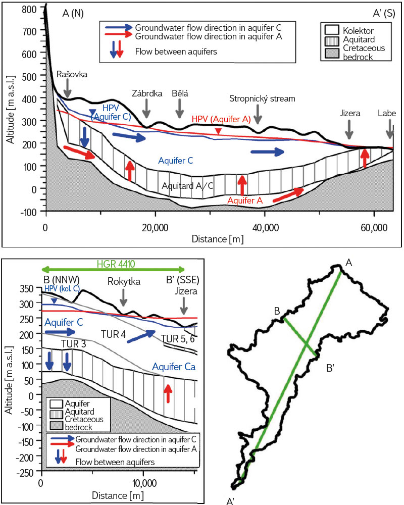
Fig. 5. Groundwater flow in region 4410; cross section N-S (top) and NNW-SSE (bottom left) with line markings of both cross sections (bottom right). Modified after [1]
In HGR 4522, there is a recharge of groundwater in the entire area; the dominant infiltration is in the N to NE of the district. Groundwater continues to flow towards the SW; in the eastern part of the district, groundwater flows from neighbouring region 4521 (169 l/s of groundwater flows in and 83 l/s flows out from region 4522 [2]). Groundwater drainage takes place in the lower part of the Pšovka, at the Liběchovka, and via the Elbe through Quaternary gravelly sands [2; Fig. 6]. From NE to SW, the thickness of aquifer C [2] is reduced in HGR 4522, which results in a large discharge increase in the lower parts of the Liběchovka stream and numerous springs. In various places of the upper reaches of the Pšovka and Liběchovka, important springs also occur. This indicates the inflow of old waters collected in Řepínský důl from the NE.
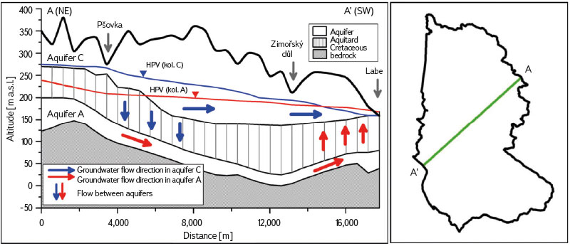
Fig. 6. Groundwater flow in region 4522; cross section NE-SW. Modified after [2]
The maximum permeability of the rocks in the area of the drainage bases, and the lowest is in the inter-river areas, where the aquifers are at their thickest. This indicates the important role of fracture systems in this area; permeability is most affected by the crossing of fracture belts in the NW-SE and NNE-SSW directions [1]. Springs often rise at these crossings, such as in the Bělá valley.
In the NW of HGR 4410, permeability provided dominantly by fractures prevails, however with a significant proportion of permeability given by pores; towards the S, the proportion of pores’ permeability decreases due to the transition to calcareous claystone, marlstone, and calcareous sandstones. Between Košátecký stream and Bělá pod Bezdězem, where aquifer C occurs with quartz sandstones up to 80 m thick, the permeability of aquifer C provided by pores and fractures. In areas without quartz sandstones, the permeability of aquifer C is almost exclusively provided by fractures, with high transmissivity (e.g., in the Bělá basin with the catchment area for Mladá Boleslav), indicating a large influence of fissures on the flow. In the higher areas between the Pšovka and Liběchovka, perched aquifers are formed [2], which are seen as springs and wells (e.g. Nedvězí).
Discharge measurement
The results of the measurements of the Strenický stream area are shown in Fig. 7. Although it is a relatively short monitored period, it can be seen that discharge is relatively constant over time (fluctuations less than 1 : 2), which means that the springs do not react to precipitation. This suggests a longer water cycle, which is consistent with the previous claim that these are old waters [1]. Monitoring spring discharge is essential for quantifying the dynamic resources of these old waters. So far, this discharge has not been monitored on most of the mentioned profiles.
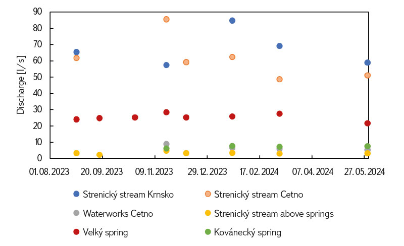
Fig. 7. Discharge measurement in the Strenický potok basin
Discharge at the first location on the Strenický stream in Krnsko ranges from 58 to 85 l/s. This is relatively low compared to archival measurements which show discharge of over 100 l/s. The Strenický stream near the village of Cetno has discharge ranging from 49 to 86 l/s. Discharge from the waterworks near the village of Cetno is 5 to 9 l/s. Kovánecký spring has a discharge from 6 to 8 l/s. The Strenický stream above Podkováň spring area has discharge of only between 2 and 5 l/s, while Velký spring is from 22 to 28 l/s. It is evident that most of the water in the Strenický stream comes from Podkováň spring area. Discharge of old water in this area is approximately 65 l/s.
Results of discharge measurements from the surroundings of the Rokytka and Kokořínsko can be seen in Fig. 8: discharge from Klokočka spring is around 1.5 l/s; the spring watercourse near the village of Nedamov reaches 14 to 26 l/s; the spring in the village of Nedamov is from 0.5 to 2 l/s; and discharge from Stříbrník spring is around 1 l/s.
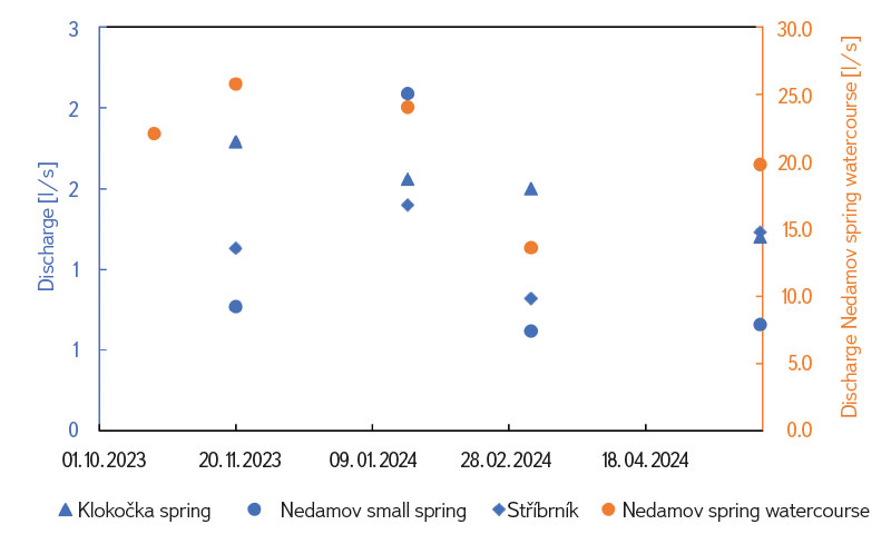
Fig. 8. Discharge measurement from Klokočka spring and the Pšovka and Liběchovka basins
Physico-chemical parameters
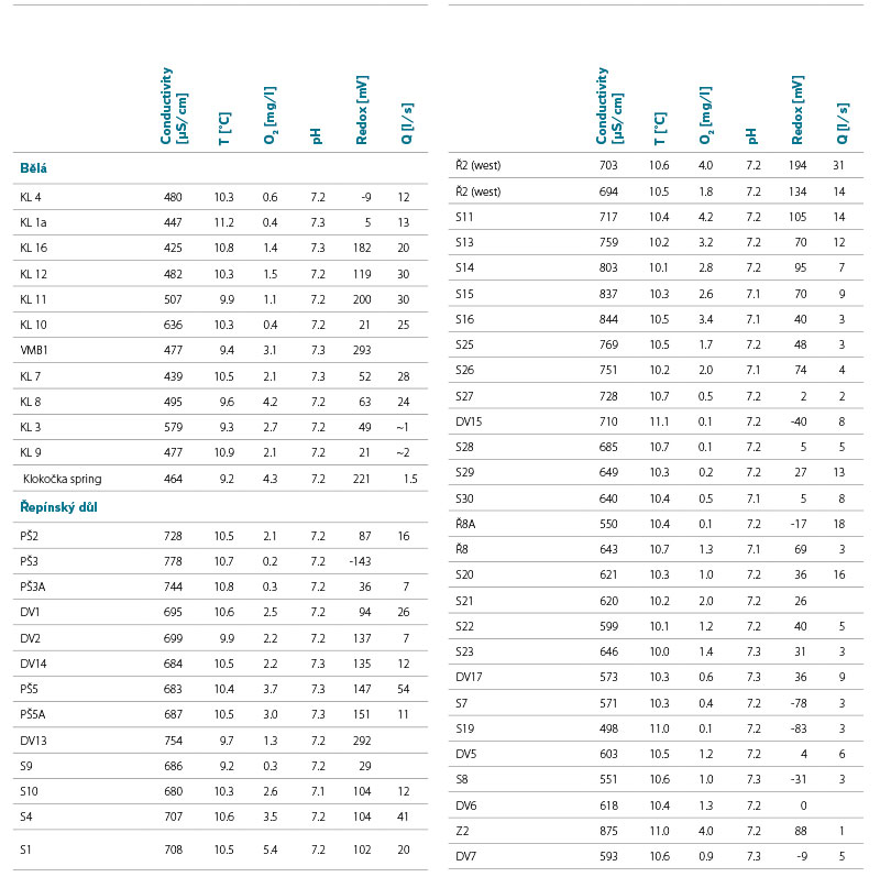
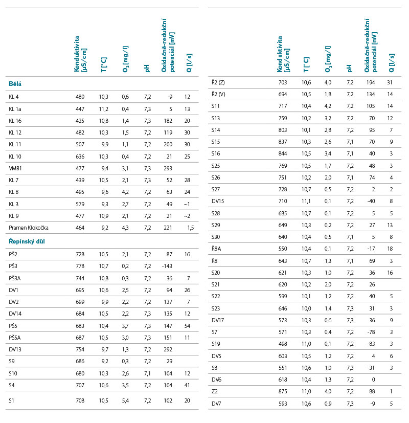
The measured physico-chemical parameters are shown in Tab. 1. Conductivity in the Bělá catchment area is lower than in Řepínský důl. While in the Bělá it ranges from 425 to 636 µS/cm, in Řepínský důl it is from 498 to 844 µS/cm. According to measurements by Kůrková [4], water originating purely from quartz sandstones has a conductivity of 100 to 300 µS/cm, while water from calcareous sandstones has a conductivity of 400 to 800 µS/cm. Therefore, the water in all measured objects of interest was probably in contact with calcareous sandstones for at least some time. Groundwater temperature is similar in both areas, from 9.2 to 11.2 °C. All monitored objects of interest have a neutral pH of approximately 7.2. Some monitored objects have a dissolved oxygen concentration < 1 mg/l, indicating an anoxic environment. The more frequent occurrence of these waters is in Řepínský důl. Oxidation-reduction potential measured with a calomel electrode ranges from -143 to +293 mV. The correlation between oxidati-on-reduction potential and dissolved oxygen was r = 0.57 (0.43 for Bělá and 0.62 for Řepínský důl), which indicates a medium degree of dependence. The range of the mentioned conductivities is within the values given for other objects of interest in the remaining parts of the studied districts [1, 2].
Tab. 1. Chemical properties of sampled sites. The order of the sites in each catchment area is arranged from lowermost to uppermost altitude. Q is abstraction from wells for water supply; for Klokočka spring it is average discharge
DISCUSSION
In the Results section, the current idea of groundwater flow in the area of interest was described as formulated in previous studies [especially 1, 2, 10] based on structural and hydrogeological data, supplemented with information from chemistry and fluctuations of groundwater levels. These are the basic results of the analysis of groundwater circulation in the area of interest, which significantly contributed to understanding of the hydrogeology in the region.
Nevertheless, in the context of low-tritium waters, there remain a number of questions that current models are unable to answer, and there are a number of inconsistencies as well as, in some cases, even contradictory information. Previous tritium analyses have come from only a limited number of objects of interest draining the structure of interest, which may be a mixture of both old and shallower, younger waters. There are also uncertainties regarding the usable amount of these waters and especially the area where these waters are formed (i.e. where their infiltration site is). It is therefore necessary to verify the existing conceptual model of the flow, supplement it and possibly modify it using new knowledge.
The infiltration site of these old waters is unknown. However, with an estimated discharge of 250–300 l/s (estimate of the total discharge of old waters according to [1, 2]) and infiltration before 1950, it is necessary to consider a pore volume of at least 6 × 10⁸ m3 to retain this water, which with the given porosity of sandstones (about 10–30 %) corresponds to a volume of 2–7 km3 of Cretaceous rocks. The volume of Cretaceous rocks in the area of interest is higher, therefore the assumed volume of the current system of old waters and infiltration into the Cretaceous rocks are realistic.
In order to answer the questions described above, during the first year of the project, samples were taken from selected objects of interest for tritium analysis, which – with relatively low cost – will initially help to distinguish old water (with low to zero values of tritium activity) from young water (with higher tritium activity, indicating the origin of water infiltrated after 1950). Subsequently, on the basis of numerous tritium analyses, a smaller number of objects of interest (boreholes, springs) will be selected for more financially demanding, but more accurate dating methods, for example using radiocarbon, CFCs, SF6, 85Kr a 39Ar.
Geological sections by Uličný et al. [8] made it possible for the first time to determine to which genetic sequences springs are bound and which rocks are highly permeable. Based on the positions of permeable rocks (especially sandstones), it is thus possible to verify hypotheses which lithologies form permeable aquifers, where water infiltration, etc. can occur. However, as Kůrková [4] points out, the aquifers defined according to these sections do not have to be formed of pure quartz sandstone; they may also contain calcareous layers. These layers of calcareous cement can be only the first few decimetres thick, while the vast majority of the aquifer thickness is made up of quartz sandstone [12]; however, even these thin layers can be sufficient to increase water conductivity.
Looking at previously measured data from springs [1, 2, 4], a weak trend can be observed where conductivity increases with increasing tritium activity (Fig. 9), i.e. water with a higher residence time tends to have lower conductivity. For HGR 4410, the correlation between tritium activity and conductivity is r = 0.53, with springs with tritium activity below 3 TU having a mean conductivity of 468 µS/cm (median 465 µs/cm), while springs with tritium activity above 3 TU having a mean conductivity of 564 µS /cm (median 558 µs/cm). For HGR 4522, the correlation is r = 0.39 and springs with tritium activity below 3 TU have a conductivity on average of 419 µS/cm (median 433 µS/cm), while springs above 3 TU have a conductivity on average of 596 µS/cm (median 535 µS/cm). For HGR 4410, according to Student’s t-test (significance level 0.05), there is a statistically significant difference in conductivity between springs with tritium activity below 3 and above 3 TU.
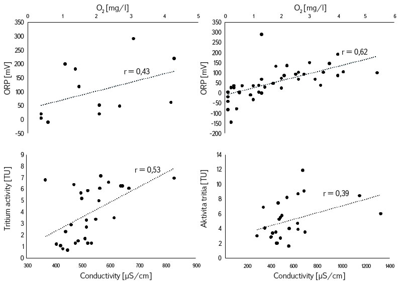
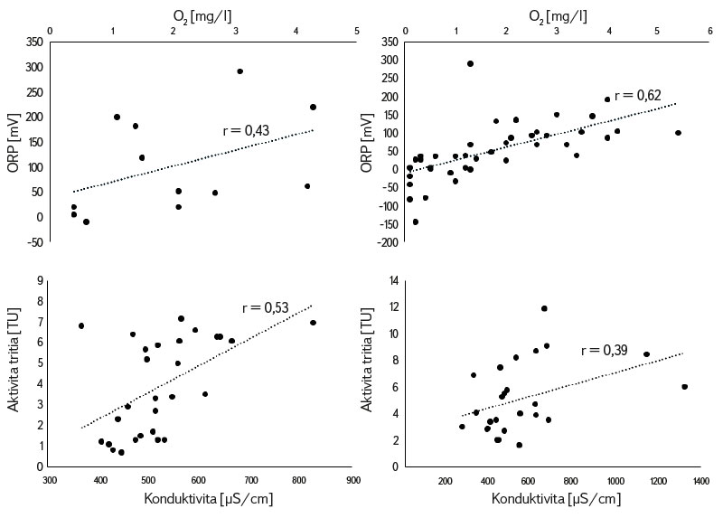
Fig. 9. Relationships between redox potential and amount of dissolved oxygen for Bělá (top left) and Řepínský důl (top right). Relationships between tritium activity and conductivity for springs in region 4410 (bottom left) and region 4522 (bottom right)
In the Bělá basin there are springs with both low and high conductivity, indicating drainage of two different waters of different chemistry, and – according to different tritium activities – of different ages (J. Bruthans, unpublished). In this context, the values of tritium and conductivity will also be verified at the newly sampled collection boreholes in Bělá and Řepínský důl, as it is not entirely clear whether the water collected in these catchment areas is exclusively water originating in Turonian aquifer C, or whether it is an outflow from Cenomanian aquifer A, at least in part at some collection facilities. Water with low tritium activity, and thus a long circulation time, may also originate from aquifer BC (TUR3 and TUR4) near Strenický stream. In the following sections, we discuss the possible flow paths of the old waters.
Probable groundwater flow paths for HGR 4522
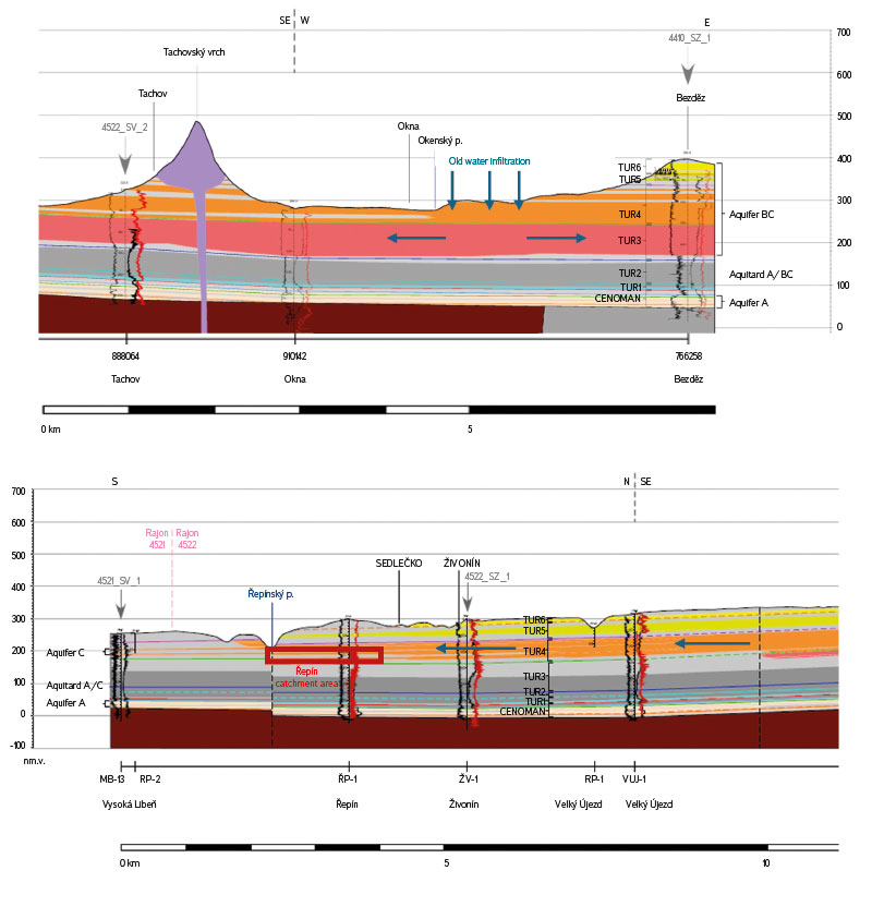
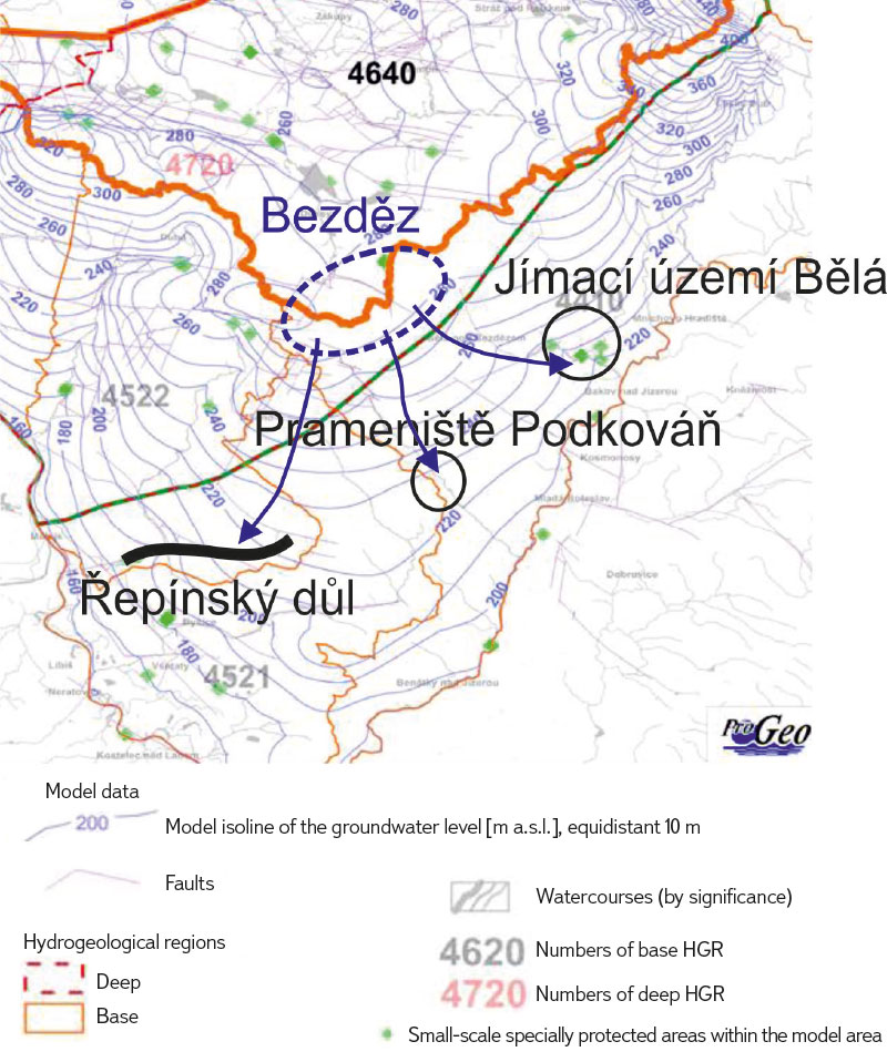
The old water in Řepínský důl has relatively lower conductivity, so it did not infiltrate through the unsaturated zone containing calcareous sandstones, but only through the quartz sandstones. The vicinity of Bezděz appears to be a probable area of infiltration, where there are outcrops of quartz sandstone of the continuous aquifer TUR3 and TUR4 [8; Fig. 10] and where, in addition (according to the groundwater level isolines), the infiltration area can be located because the groundwater level here is much higher than in the drainage areas of old waters [2; Fig. 11]. This water would subsequently flow from the east around the elevation of the base of aquifer C and the numerous faults between Dubá and Mšeno (fault failure system south of Dubá) and then turn SW towards Řepínský důl (Fig. 11). Towards Řepínský důl, quartz sandstones TUR3 and TUR4 gradually pass into calcareous sandstones. This can cause an increase in water conductivity in Řepínský důl to values from 400 to 800 µS/cm (Tab. 1), which indicates water from quartz sandstones that has passed through calcareous layers [4].
Fig. 10. Top – Geological cross section of the Bezděz area with continuous collectors TUR4 and TUR3, indicating the possible directions of water flow (blue arrows), direction W-E. Bottom – Geological cross-section from Kokořínský důl to the Řepín catchment area (red rectangle) with an indication of possible water flow directions (blue arrows). Modified after [8]
Fig. 11. Model isolines of the groundwater level from a model from PROGEO, s. r. o., with marking of the probable location of infiltration of low-tritium waters (blue oval) and the direction of water flow (blue arrows). Modified after [1]
Another possible source is outflow from the Cenomanian aquifer. As shown in Fig. 6, in the area of Řepínský důl (especially in its lower parts), a change in the situation occurs even with unaffected water levels when Cenomanian water already flows from aquifer A through aquitard A/C to aquifer C. However, if outflow of Cenomanian water occurred in the lower parts of the catchment area, a change in physico-chemical parameters could be expected here, such as a decrease in the amount of dissolved oxygen and a decrease in the redox potential which, however, is not apparent from Tab. 1. The dating of the water from these collection boreholes can further support or disprove this assumption.
Simultaneously, the question arises as to where the old water from Stříbrník spring and in the spring area near Nedamov comes from because, according to the known water levels in these areas, the level in aquifer A is lower than in aquifer C (Fig. 6, Fig. 11); therefore, there should not be outflow from the Cenomanian aquifer. At the same time, the isohypses of aquifer C (TUR4) in Fig. 11 are not affected by tectonic disturbances, which is contrary to the spatial variability of rock permeability, which is most affected by the crossing of fracture belts, to which springs are often connected [1, 2]. It thus remains an open question whether, for example, in the area of Stříbrník spring, outflow from the Cenomanian aquifer through fissures cannot occur locally.
Probable groundwater flow paths for HGR 4410
On the basis of contemporary knowledge, it is possible to assume that the old water springing from Strenický stream and collected in Bělá came into contact with limestones only for a limited time [4], i.e. it infiltrated in places of quartz sandstones. Again, the area of infiltration for the Bělá catchment may be in the vicinity of Bezděz, where outcrops of quartz sandstone TUR4 reach the surface. Infiltrated water would move further through the continuous aquifer TUR4 and TUR3 and reach the surface along the faults or at the places of gradual disappearance of these aquifers (Fig. 12). Another possibility is outflow from the Cenomanian aquifer which, according to Fig. 5, has a groundwater level in the Bělá catchment area at a very similar level to aquifer C, and according to [7] even higher.

Fig. 12. Geological cross-section from Bezděz towards the Bělá catchment area (red rectangle), with indications of possible water flow directions (blue arrows). Modified after [8]
CONCLUSION
The goal of the presented project is to specify and quantify water sources in HGR 4410 and 4522, which according to previous studies can have a residence time of at least 70 years (in some cases significantly more). The infiltration of this old water is probably in the vicinity of Bezděz, where there are sandstone outcrops without carbonate cement. This old water then flows through the continuous aquifer TUR3 and TUR4. Given the discharge of springs, sandstones occupy a sufficient volume for its accumulation and residence time. In order to quan-tify the dynamic sources of these waters, discharge monitoring is carried out on selected streams and springs with a low concentration of tritium. All monitored objects of interest show stability of discharge over time, which means longer circulation without the influence of local meteorological conditions. Selected objects of interest used for drinking water supply were sampled to determine the age of the water based on tritium activity. Based on the results, objects of interest will be selected for which the age will be refined based on the analysis of CFCs, SF6, and other dating techniques. The project is currently entering its second year. The following actions include on-going evaluation of newly acquired hydrochemical, water management, and hydrogeological data, creation of relevant maps, sections and design of water supply utilization of resources, and protection of hydrogeological structure. A detailed survey of the hydrogeology of the area will lead to an update of the conceptual model of water flow in both districts, especially with regard to the origin of long-circulation water.
Acknowledgements
The authors thank J. Bruthans for consultation on the conceptual flow model and for assistance in sampling and measuring flow rates. Research within the project SS06010268 “Poznání, kvantifikace a ochrana strategických zdrojů podzemní vody české křídové pánve hlubokého oběhu v hydrogeologických rajonech 4410 a 4522 (Identification, quantification and protection of strategic deep-flow groundwater resources in the Bohemian Cretaceous Basin, in hydrogeological regions 4410 and 4522)” is co-financed by the Technology Agency of the Czech Republic.
The Czech version of this article was peer-reviewed, the English version was translated from the Czech original by Environmental Translation Ltd.
