ABSTRACT
The paper highlights the fact that some significant watercourses dry up during periods of minimal flows due to groundwater abstraction. It provides a summary of the most affected significant watercourses in the Czech Republic. Large concentrated groundwater abstraction has a considerable impact on small and medium-sized watercourses.
To select the most significant effects of abstraction on stream flows, we used the ratio of abstraction to 355-day flows from 1931–1960. Watercourses exceeding 30 % were selected. In half of the selected cases the following relationship was confirmed: the 355-day flow from 1931–1960, reduced by the abstraction rate, is approximately equal to the 355-day flow from 1991–2020. The cases where this relation-ship does not apply can be explained by changes in abstraction volumes, declining groundwater levels and flows in the wider area due to groundwater collection and the use of static groundwater reserves. The effect of climate change is unlikely to be present in the baseflow in the cases studied.
Our analysis identified 13 cases where groundwater abstraction is severely affecting the flow of significant watercourses. In about half of these cases, there is an alternative source of water that should be used when the flow of the watercourse is at a minimum. Another option to protect water resources is to apply the minimum groundwater level or minimum residual flow under the Water Act.
A comparison of the 13 sites most affected by groundwater abstraction showed the consequences of groundwater overexploitation. In the catchments of the Dědina, Doubrava, Bělá, Liběchovka, Úštěcký stream, Blšanka, and Jevíčka, groundwater abstraction is significant, but the hydrological regime has not yet been completely changed. In other cases, the situation is more serious, with substantial depletion over a wider area. Decreases in stream flows and groundwater levels are often felt in neighbouring catchments. According to our findings groundwater abstraction in the catchment areas of the Bechyňský stream, Rakovnický stream, Pšovka, Blata, Romže, and Svitava had the most significant impact on the hydrological regime.
INTRODUCTION
A manifestation of climate change in the Czech Republic is a steady increase in average air temperature over the last 50 years, while average precipitation totals have not changed much. Due to higher temperature (if there is enough precipitation), there is greater terrestrial evaporation, which leads to more pronounced aridity in the soil and in surface water and groundwater. Adaptation to drought is carried out through long-term plans and measures, as well as draft measures for the immediate solution of water shortage, which are part of the so-called drought plans according to Section 87b of the Water Act. Surface and groundwater resources are limited, which requires coordination of their use during drought. One of the long-term adaptation measures is to enable substitutability of water resources. Larger cities (consumers) often have more substitutable resources, but it is not the rule.
Surface water abstraction undoubtedly reduces flows in watercourses in reaches of different lengths depending on the remoteness of the abstraction site and the discharge of used (waste) water. The influence of surface water abstraction on water quality is also obvious and, with low flows, quite significant. In the case of groundwater abstraction, the effect on stream flow is not so direct, but it is similar. Depletion of flows occurs in several ways. This is obvious when collecting springs that form or formed part of a watercourse flow. The depletion of watercourses also occurs through groundwater withdrawal using boreholes and wells; in fact part of groundwater forming springs (Figs. 1 and 2) at the site of the drainage base of the water-bearing system or inflows of groundwater into watercourses and reservoirs is abstracted. The yield of the springs decreases as a result of extraction from boreholes; sometimes they disappear completely, which is described, for example, in the Hřensko intake area [1]. Similarly, there is a decrease in groundwater discharge below the levels of watercourses and reservoirs. Another way of reducing a watercourse flow is the groundwater withdrawal in a floodplain using bank infiltration.
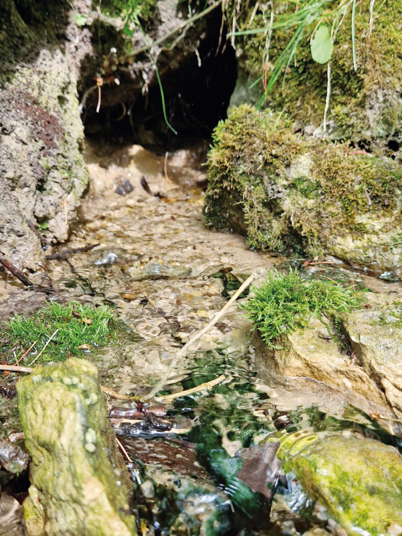
Fig. 1. Natural spring emerging from the Cretaceous sandstones of the Kokořínsko region forming part of the Liběchovka flow
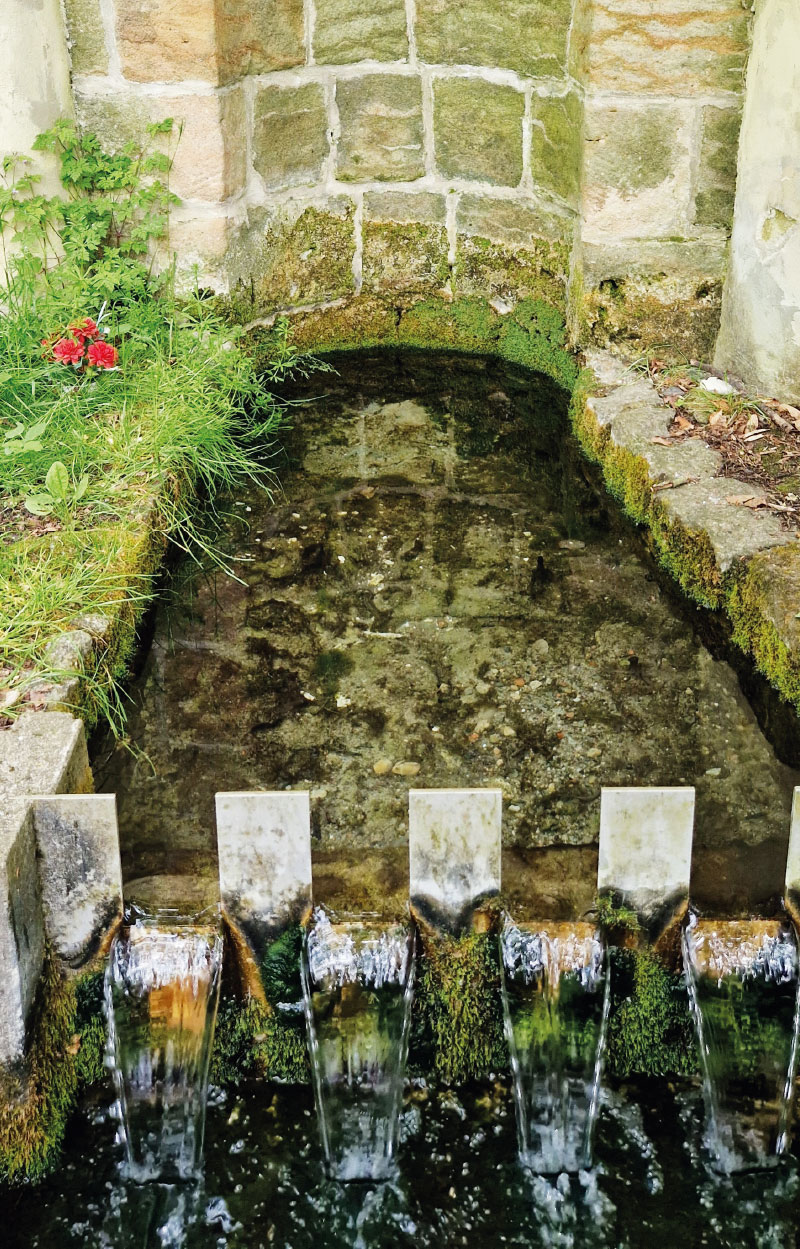
Fig. 2. St. Vojtěch spring in the Cretaceous sandstones of the Kokořínsko region forming part of the Liběchovka flow
METHODOLOGY
From the recorded groundwater abstraction for 2021 in the Czech Republic [2], the largest abstractions were selected and compared with the flows in watercourses that they may have an influence on. Only significant watercourses were monitored, based on Decree No. 178/2012 Coll. During the comparison, the 355-day flow (Q355d) was considered, which represents the status of low flows. With regard to the affection of stream flows by the abstractions themselves, but also by operations on the reservoirs or wastewater discharge, the values of Q355d from 1931–1960 [3] were used. Groundwater abstraction on a massive scale began to be carried out from the 1970s. Within the basin of one watercourse with a known Q355d, abstractions were combined and their values added up. As a rule, there are no significant fluctuations in water supply abstraction during the year. Annual groundwater abstraction was recalculated to the average instantaneous abstraction. By dividing the average groundwater abstraction and Q355d from 1931–1960, we get an idea of a possible reduction of a watercourse flow due to abstraction. The choice of a watercourse profile was limited by available data, so it may not be ideal for objective assessment of the influence of the abstraction on the flow. Naturally, the greatest influence of abstraction on flows occurs in cases of large abstraction and small watercourses. Tab. 1 shows groundwater abstraction where the amount abstracted is more than 30 % of the Q355d flow of the respective watercourse. The influence of surface water abstraction, wastewater discharge, and operations on reservoirs on the flows of selected watercourses, was assessed and found to be negligible.
Natural and hydrogeological conditions of selected watercourses in connection with respective abstractions
Thirteen watercourses were selected in the manner described above. These watercourses lie at lower altitudes in the wider central part of the Czech Republic, from Ústí nad Labem to Olomouc and South Moravian Regions. The largest number of these watercourses is in the Central Bohemian Region. The areas of hydrological basins of the selected watercourses range from 51 to 384 km2.
From a hydrogeological point of view, the selected groundwater abstractions are mainly located in permeable Cretaceous and Quaternary sediments. In contrast, the most widespread hydrogeological environment in the Czech Republic is completely absent here – the hydrogeological massif, which usually does not allow concentrated abstraction of higher groundwater discharge. From the point of view of the affected hydrogeological zones, the zones in the Czech Cretaceous basin predominate. There are nine selected reaches of the Dědina, Doubrava, Bělá, Pšovka, Liběchovka, Úštěcký stream, Blšanka, Jevíčka, and Svitava watercourses.
RESULTS
Among groundwater abstraction affecting the flow of watercourses, abstraction for treating drinking water for public water supply systems of large towns predominates in the vast majority. Water abstraction for large towns is often concentrated on abundantwater resources, where depletion is not so fundamental; however, an adequate level of use must be maintained with regard to watercourses and groundwater reserves at the abstraction site and the surrounding area.
Tab. 1 lists 13 sites in the Czech Republic where groundwater abstraction significantly affects the flow of medium-sized or small watercourses during low flow periods. In most cases, the abstracted groundwater travels to distant consumers in other basins. Only in two cases (Rakovnický stream and Romže) is the majority of the abstracted groundwater returned to the stream by discharging wastewater at a short distance of about 5 km below the abstraction point.
Tab. 1. Groundwater abstraction in 2021 that greatly affected watercourses (in hydrological order)
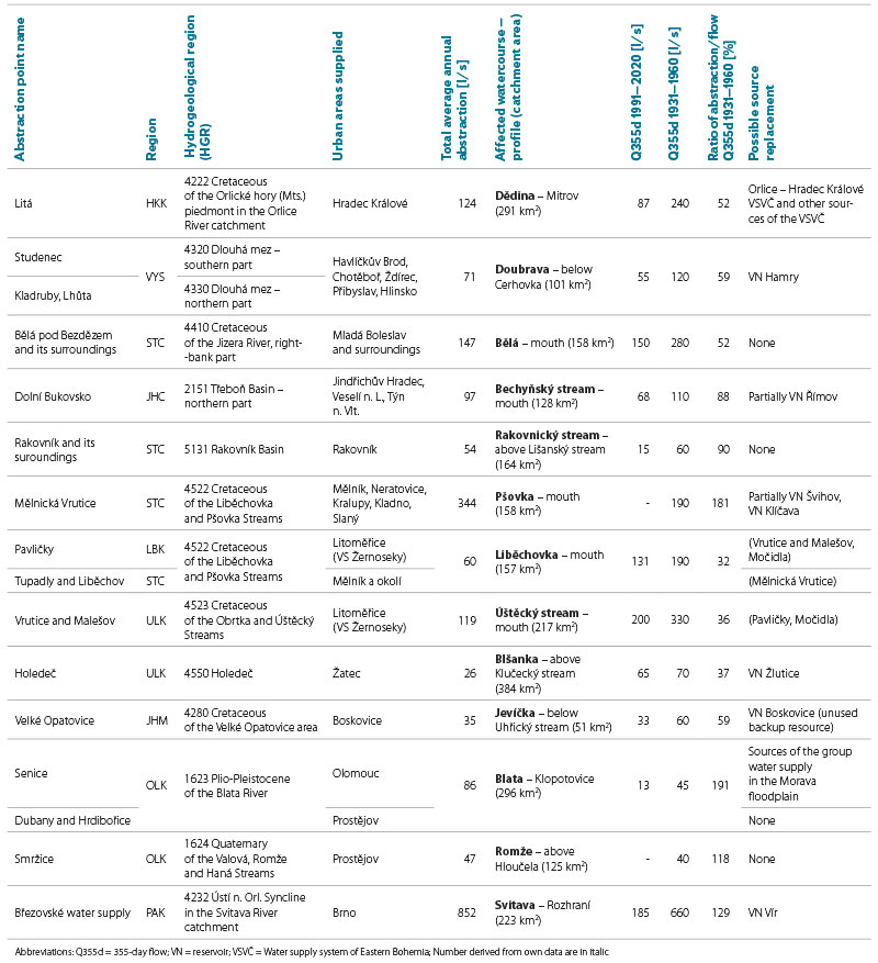
Percentage evaluation of the degree of influence of abstraction on flow, as shown in Tab. 1, provides a general summary of the significance of abstraction in individual locations, but also depends on the location of the profile on the watercourse. Profiles with available Q355d values were used for assessment. Selected watercourses and groundwater abstraction sites that influence their flow rates are shown in the map in Fig. 3.
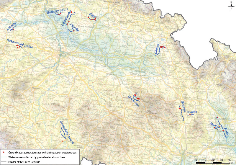
Fig. 3. Significant impacts of groundwater abstractions on stream flows have been identified at 13 locations in the Czech Republic; the map shows each affected watercourse section with the corresponding abstraction sites
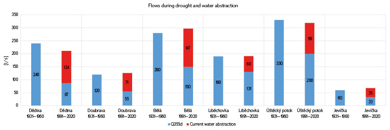
For further analyses, 355-day flows derived from observations of influenced flows in 1991–2020 were also used. In half of the cases, we can see the relationship between the average abstraction, Q355d from 1991–2020 and Q355d from 1931–1960. The sum of the average abstraction and Q355d (1991–2020) in these cases approximately corresponds to Q355d (1931–1960) for the Dědina, Doubrava, Bělá, Rakovnický stream, Liběchovka, Úštěcký stream, and Jevíčka, as shown in the graph in Fig. 4. The 355-day flow can be regarded as an approximate level of baseflow in the dry season. Thus, the decrease in Q355d from 1991–2020 compared to Q355d from 1931–1960 roughly corresponds to the size of the respective groundwater abstraction.
 Fig. 4. Comparison of 355-day flows, past and present. The reduction in 355-day flows corresponds to the amount of groundwater abstracted in the selected catchments. Cases of abstraction affecting larger areas across catchment boundaries are not shown
Why is this not true in all cases? Why is abstraction in some cases greater than the original baseflow? There are several reasons:
Groundwater abstraction already took place to a lesser extent in 1931–1960. An example is the Březová nad Svitavou intake area, where groundwater collection by the First Březovský Water Supply System for Brno started in 1914 and, by 1975, about 300 l/s was abstracted [4, 5]. The 355-day flow in Svitava from 1931–1960 is therefore not uninfluenced. Similar cases are: Smržice intake area, near Prostějov, in the Romže basin, which has been used since 1906; Holedeč intake area, near the Blšanka, with a water treatment plant from 1933 supplying water to Žatec district; Vrutice intake area, supplying water to Litoměřice since 1903; and Rakovnický stream intake area, which became the main source of water for Rakovník in 1944.
Collecting groundwater also depletes resources in the wider area in the basin of other watercourses, reducing their flow. Examples are the intake areas of Mělnická Vrutice, Holedeč, Dolní Bukovsko, and the intake area in the Blata basin. Water collection can cause a change in the direction of groundwater flow, thereby increasing the extent of the area from which groundwater flows to the collection points. In the case of deeper boreholes, deeper aquifers may be affected, often draining at a great distance from the point of abstraction into distant watercourses.
Groundwater can also be temporarily pumped from static reserves, which is described in the cases of the Mělnická Vrutice [6], Dolní Bukovsko [7], and Rakovnický stream [8] intake areas.
Groundwater abstraction from 1991–2020 was, in some cases, less than in 2021, which was used for the analysis. In the case of abstraction in the Bělá, Blata, Romže, and Jevíčka basins, the increase in the amount of abstracted water (up to 20 %) probably caused a slight discrepancy. With the slightly reduced abstraction values in these four cases, the sum of abstraction and Q355d (1991–2020) is closer to that of Q355d (1931–1960).
Groundwater abstraction from 1991–2020 was, in some cases, greater than in 2021. The slight decrease in the amount abstracted explains the slight discrepancy in the values in the Dědina basin on the same principle as stated in point 4. The decrease in abstraction for Malešov water treatment plant contributes to the explanation of the discrepancy at the Úštecký stream.
The influence of climate change can also play a role. By comparing the 355-day flows from 1931–1960 and 1991–2020 in watercourses not significantly influenced by surface water abstraction, discharge, and operations on reservoirs, we find that there has been a decrease in some of the watercourses (Fig. 5). Higher temperatures in the later period caused more evapotranspiration from the catchment if water is available in the surface layer; therefore, runoff from the catchment may be lower. Minor changes in precipitation totals in some parts of the Czech Republic do not have a major effect on Q355d.
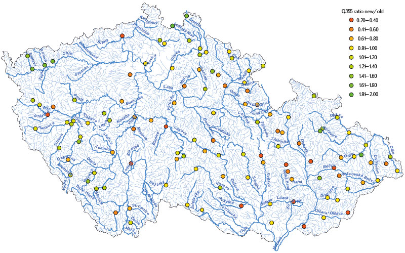
Fig. 5. Change in 355-day flow in stream profiles; coloured points show the ratio between Q355d from 1991–2020 and Q355d from 1931–1960
Values of 355-day flows may be affected by errors in observation, evaluation, and derivation of flows.
It was quite surprising to find that the difference between the current Q355d and the historical Q355d from 1931–1960 can be explained in all cases examined by the size of current abstraction and the reasons 1–5 mentioned above. Based on our findings, climate change does not play a significant role here. The reason may also be the fact that 1931–1960 is one of the drier periods.
Weakening of baseflow from Cretaceous aquifers as a result of climate change probably does not occur for the reason that the replenishment of the aquifers takes place mainly from winter precipitation, which is not reduced in quantity, and from watercourses in their loss reaches (e.g. at the outcrops of aquifers). Water resources in the Cretaceous sandstone aquifers are large and provide year-round continuous replenishment of the watercourses. Total annual runoff for most watercourses is reduced due to climate change [9]. The reason is mainly the weakening of subsurface runoff (interflow) in the growing season, when evapotranspiration is higher due to higher air temperature.
Reduction of watercourse flows and groundwater levels caused by groundwater abstraction has been observed in many locations in the Czech Republic over the recent decades. One of the tools for rectifying such conditions is the minimum groundwater level and minimum residual flow under the Water Act, which have been applied successfully in several cases. For example, in the past, groundwater abstraction in the Podlažice intake area greatly influenced the flow of the Žejbro in the Chrudimka basin, until it dried up. A minimum groundwater level was introduced for the intake area with four groundwater levels in the monitoring borehole, according to which the maximum possible amount of groundwater abstraction is governed. Given that there are other sources of drinking water in the area (e.g. Seč and Křižanovice reservoirs on Chrudimka), the Žejbro has not dried up since the introduction of the minimum groundwater level.
Of the 13 groundwater abstraction sites that are the subject of our analysis, the minimum groundwater level is applied in the intake areas of Litá, Dolní Bukovsko, Mělnická Vrutice, and Březová. Moreover, for the Dolní Bukovsko intake area, there is a minimum residual flow of 50 l/s in the Bechyňský stream. For the Litá intake area, restriction of groundwater pumping to protect marsh communities only applies from 21 March to 15 July. The introduction of these limits has improved the status slightly; however, due to the long period of time for which groundwater abstraction has been carried out, the natural state of surface water and groundwater is not well known; not many people remember it, and therefore it is not enforced. The determination of the value of minimum groundwater level itself does not always correspond to the definition provided in Section 37 of the Water Act: “The minimum groundwater level is the level that still allows sustainable use of water resources and that ensures achievement of good ecological status of related surface water bodies and excludes significant damage to terrestrial ecosystems.” Further application of the aforementioned minimum groundwater level and minimum residual flow is appropriate in cases of overexploitation of water resources, the most significant cases are listed in Tab. 1.
Tab. 1 also contains information on urban areas supplied from assessed sources. Only larger towns that consume vast majority of water are listed. In the last column of Tab. 1, possible alternative water sources for the given consumption facilities are proposed. These are often reservoirs that have sufficient capacity. Some sources are normally used, others are only supplementary due to the higher price of abstraction and surface water treatment, and others are shut down (Boskovice reservoir). In some cases, no other major source is connected to the water supply system, it can be a risk for reliable water supply in general, but also for watercourses and water-dependent ecosystems, which can be damaged or destroyed during drought due to large irreplaceable abstraction.
Sufficient groundwater reserves, which are often claimed by water supply operators, do not always go hand in hand with sufficient water in rivers, as was shown at the 13 surveyed locations. For the sake of interest, we can mention the opposite situation, when pumped groundwater flows after use into a watercourse, which is not the drainage base of the aquifer from which it was pumped. It therefore has an improving effect for flow rate in the watercourse and this is appreciated during drought.
DISCUSSION
In the works of Prchalová [10] and Venera [11], groundwater abstraction is compared with natural groundwater resources, or with the exploitable amount of groundwater on the scale of hydrogeological zones. This paper compares groundwater abstraction with dry season stream flows consisting predominantly of baseflow at the scale of 51 to 384 km2 catchments. Based on the results of the studies [10, 11] and this article, areas of excessive groundwater extraction, unsurprisingly, coincide in many cases. Due to the different investigated sources (groundwater and watercourses), there is no agreement if the drainage base of the “affected” hydrogeological zone is a large watercourse. Its flow will not be affected by groundwater pumping in a significant way, despite the fact that groundwater reserves are overexploited. Furthermore, there is understandably no agreement in cases where the basin of the examined watercourse only forms a small part of the hydrogeological zone (HGR). In contrast to previous works [10, 11], a significant influence of groundwater abstraction in the Bělá basin was identified in HGR 4410 Cretaceous of the Jizera River, right-bank part, where groundwater resources are plentiful; however, the 355-day flow of the Bělá at the confluence with the Jizera is currently roughly half that of the period before building a group water supply system for Mladá Boleslav. In addition to the influence of increased abstraction in recent years, the method of determining exploitable reserves for HGR 4410 in the “Rebalancing of groundwater reserves” project, which is the basis of the Venera publication [11], also plays a role here.
The relationship between groundwater abstraction and watercourse flows is also dealt with by individual River Basin Authorities. In a report from the Vltava River Basin Authority [12], it is stated that the main drainage stream for HGR 2151 is Bechyňský stream, and the baseflow here is significantly influenced by the abstraction of groundwater in Dolní Bukovsko. In HGR 5131 Rakovník Basin, the pumping of a large amount of groundwater reserves, which then cannot flow away by gravity to their natural drainage bases – the Rakovnický stream and its tributaries, can be seen in the vicinity of Rakovník [8].
The Pšovka, Liběchovka, Úštěcký stream, and Blšanka watercourses are investigated within the territorial scope of the Ohře River Basin Authority. It is these watercourses that periodically experience a stressed water management balance [13], i.e. the average monthly flows fall below the Q355d value. Among other things, excessive groundwater abstraction by waterworks contributes to the decrease in flow rates of some of these watercourses [13]. The greatest negative impact is recorded on the Pšovka, whose part has been drying up completely in the summer months [14]. Furthermore, the Blšanka water bearing is significantly affected by groundwater abstraction from the Holedeč intake area [11] in HGR 4550 Holedeč, from which the groundwater is drained into the Blšanka through numerous fractures [14]. The Liběchovka flow is dealt with in the final report of the “Rebalancing of groundwater reserves” project [6], within which measurements of gradual profile flows were carried out. In the reach of the Liběchovka between Chudolazy and Želízy, where the Tupadly intake area is located (Fig. 6), the Liběchovka flow decreased by around 30 l/s in October 2013 and June 2014. The average monthly abstraction in the Tupadly intake area was 33 l/s in October 2013 and 37 l/s in June 2014. The annual average abstraction in 2021 and 2022 was 37 and 44 l/s.
The Morava River Basin Authority manages the investigated watercourses Jevíčka, Blata, Romže, and Svitava. On the Blata watercourse, a stressed balance status has appeared repeatedly since 2009. One of the reasons is the abstraction of groundwater in the floodplain between the Morava, Blata, and Romže [15]. Similarly, a stressed balance status is very common on the Svitava. The main reason is the significant volumes of groundwater abstraction for First and Second Březovský Water Supply Systems [15]. Compensation for the amount of water abstracted is provided by Letovice reservoir on the Křetínka which flows into the Svitava at river km 19, below the Březová intake area. The balance status of the Jevíčka and Romže is not assessed; however, the influence of abstraction on the Romže in the Smržice intake area is evident because the collection system is based on bank infiltration from Romže. Two weirs have been built on the Romže in order to store water for the Smržice intake area, where seven collection points are excavated along the Romže [16]. In Velké Opatovice, the Zámecké springs (which feed the Jevíčka) are captured. The groundwater of aquifer B is exploited by a syphoning the natural springs as well as by a series of boreholes [17].
In relation to groundwater abstraction in hydrogeological zones 4222 and 4410, the report of the Labe River Basin Authority [18] states that abstraction in the Dědina (HGR 4222) and Bělá (HGR 4410) basins do not cause a reduction in static groundwater reserves. Whether or not the mentioned abstraction reduces the flows in the Dědina and Bělá has not been assessed. Furthermore, the report [18] states that groundwater abstraction in the Doubrava basin (HGR 4320 and 4330) cannot fundamentally threaten the natural resources of the groundwater body, and the reduction in flow in the Doubrava caused by abstraction is compensated by Pařížov reservoir. Based on our knowledge, improvement of the Doubrava flow rate during drought is not expected due to the complete emptying of the reservoir active storage in the past drought periods. The main purpose of Pařížov reservoir is to mitigate the passage of floods and, among other things, to produce electricity.
Comparison of M-daily flows for 1981–2010 and 1991–2020 is provided in the article by Kukla [19]. Decreases in 355-day flows amount to an average of 13.4 % in a set of 304 water gauging stations in the Czech Republic. Kukla notes that, in general, there was more water in 1981–1990 than 2011–2020. Prolonged periods of minimum flows were observed during 2014–2019 when there were long periods without precipitation. This explains the difference between the 355-day flow values in the compared periods. Our comparison of 355-day flows from 1931–1960 and 1991–2020 at 129 water gauging stations shows an average decrease of 3 %; stations with little influence on flows by human activity were selected. Considering the inaccuracies of the observed and derived values, a decrease of 3 % can be considered insignificant. The ČSN 75 1400 standard gives an indicative value of the probable error of the 355-day flow values of 20 %.
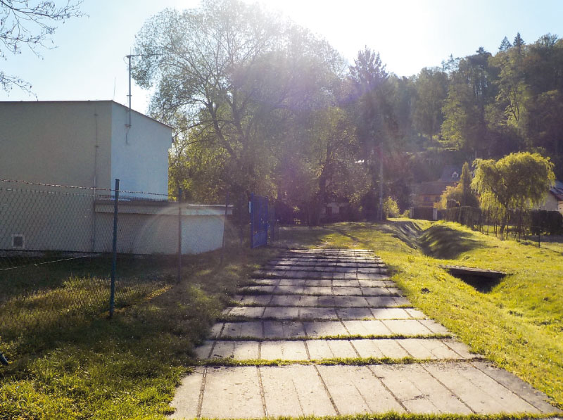
Fig. 6. Groundwater abstraction facility at Tupadly in the Liběchovka catchment
CONCLUSION
The result of our analysis is the identification of 13 locations where the amount of groundwater abstraction exceeds 30 % of a watercourse flow in the dry season. This article deals only with major groundwater abstraction and its impact on important watercourses. Lower groundwater abstraction has a similar effect on smaller watercourses of local importance. The drying up of watercourses is already observed in the driest regions in the Czech Republic. However, in the cases of watercourses considered in this article, the cause of severely depleted flows is water abstraction. Controlling the rate of abstraction from surface and groundwater sources is influenced, among other things, by the level of fees for abstracted water, which manifests itself in greater pressure on groundwater, which in this respect is significantly cheaper than surface water. Within water supply systems, there are often sources of surface water, the greater use of which is possible and would be supported by the equalization of fees for the abstraction of groundwater and surface water. These are mainly reservoirs intended for water supply. Another positive effect of most of these reservoirs is the improvement of flows in watercourses during dry periods.
In the future, climate change will bring with it a further rise in temperatures, which will be most evident in watercourses where the situation is already stressed and drying up is underway. It is necessary to prepare for issues and use or look for other sources of water. We should ensure the possibility of using existing unused reservoirs for water supply purposes and to consider the construction of new reservoirs. The advantage of reservoirs is that, unlike groundwater aquifers, the outflow of the retained water can be regulated. Another contribution to the increase of groundwater reserves, i.e. the flow of watercourses in the dry season, is the support of rainwater infiltration into the rock environment, for example by means of infiltration features. It is also important to protect significant infiltration areas from construction and pollution. Flows in dry periods can also be enhanced by removing inappropriate drainage facilities on both agricultural and forest land. If long-term conceptual measures are missing, water authorities must take measures in dry periods to limit water consumption by households, which are the main consumers of groundwater.
Acknowledgements
The article was created as part of the project “Predikce, hodnocení a výzkum citlivosti vybraných systémů, vlivu sucha a změny klimatu v Česku, PERUN (Prediction, evaluation and research of the sensitivity of selected systems, the effect of drought and climate change in the Czech Republic, PERUN)” (SS02030040), which is supported by the Technology Agency of the Czech Republic.
Explanation of terms used
355-day flow – flow that is reached or exceeded on a long-term average for 355 days a year.
Aquifer – an underground layer of water-bearing material.
Baseflow – part of stream flow maintained by groundwater discharge, usually keeping at least some water in the stream even during extended dry periods; it is one of the three components of the total runoff, with the others being surface runoff and subsurface runoff.
Drainage base – the place where groundwater from the water-bearing system flows to the earth’s surface under the influence of gravity
Dynamic groundwater reserves – the amount of groundwater flowing from aquifers to waterways or other aquifers; in natural conditions, they correspond (in the long-term) to natural groundwater resources and form baseflow.
Evapotranspiration – the combination of water evaporation and plant transpiration, i.e. water vapour from the surface of the earth and release of water vapour through the surface of plants.
Groundwater body – volume of groundwater within an aquifer.
Groundwater collector – a permeable rock environment with the ability to accumulate water.
Hydrogeological zone – area with similar hydrogeological conditions, type of aquifer, and groundwater circulation.
Natural (renewable) groundwater resources – the amount of water under natural conditions replenished in the long term by infiltration into an aquifer or water-bearing system (definition from Annex No. 8 of Decree No. 369/2004 Coll.). Natural resources are usually determined as the value of uninfluenced baseflow from the hydrogeological structure. Baseflow naturally changes over time depending on the season and the weather in the previous period. The characteristic value for the given period can then be median or average baseflow.
Bank infiltration – interaction between surface water and groundwater; taking water from a watercourse caused by the difference in levels in the stream and at the place of groundwater collection objects in the floodplain.
Static groundwater reserves – the amount of groundwater that does not flow from aquifers to waterways or other aquifers (if they are pumped, there may be a permanent drop in the groundwater level).
Uninfluenced flow – natural flow that is not influenced by reservoirs, abstraction, and discharge.h, odběry vody a vypouštěními
Exploitable amount of groundwater – the amount of groundwater that can actually be used from an aquifer or water-bearing system without negatively affecting groundwater or the surrounding environment (definition from Annex No. 8 of Decree No. 369/2004 Coll.).
The Czech version of this article was peer-reviewed, the English version was translated from the Czech original by Environmental Translation Ltd.
