INTRODUCTION
Watershed or catchment area are used as basic input data for a whole range of water management-oriented activities, whether it is rainfall-runoff modelling, calculation of the water management balance, preparation of flood plans, or the use of watersheds as one of the data sources for spatial analysis. A catchment area, defined by its watershed, is also a necessary basis for deriving standard and non-standard hydrological data according to the standard ČSN 75 1400 Hydrological data of surface waters [1] and, at the same time, is the basic spatial unit used in hydrological practice.
The definition of a catchment is enshrined in Act No. 254/2001 Coll. (hereinafter referred to as the Water Act) [2], where a catchment is an area from which all surface runoff flows into the sea through a network of watercourses and possibly lakes. A sub-catchment is an area from which all surface runoff flows through a network of watercourses and lakes to a certain point in the watercourse, which is usually a lake or a river confluence. According to decree 252/2013 Coll. [3], hydrological catchments are registered in the form of a polygon based on data from their numerical identifier and the size of the area and are determined on the basis of the hydrological structure of water channels. This identification is the responsibility of the Czech Hydrometeorological Institute (CHMI). From the above it is clear that, in order to accurately determine the watershed of sub-catchments, it is necessary to have the most accurate topographical data available, i.e. the river network with confluences, a defined hydrological structure (the stream order of the mouths of watercourses), as well as the most accurate information about the altitudes of the given area for the correct management of the watershed. In the Czech Republic, CHMI is also responsible for the spatial delineation and numerical registration of watersheds.
Watersheds of primary catchment areas have a long history starting in the second half of the 20th century, when the first hydrological delineation of watercourses was published, in L. Horský et al. Hydrologické poměry ČSSR (Hydrological conditions of Czechoslovakia) [4]. With the refinement of the necessary documents, it was also necessary to update the watersheds of the primary catchment areas over the years so that the spatial resolution corresponds to the standards commonly used in state administration. At the same time, from about 1997, there was a transition from paper printed maps, such as the already mentioned Hydrological conditions of Czechoslovakia and the Basic water management map on a scale of 1 : 50,000 (https://www.dibavod.cz/63/puvodni-tistena-zakladni-vodohospodarska -mapa-1:50-000.html), to digitizing watersheds, which subsequently made it possible to perform the first spatial analyses for the needs of hydrological computer modelling. Digitization of watersheds to a scale of 1 : 25,000 took place from around 2001, followed by refinement of the data set of substations to a scale of 1 : 10,000 from 2008.
In the last few years, watersheds of fourth-order catchment areas have been updated in response to the completed fifth generation digital relief model at a spatial resolution of 2 x 2 m [5] and the ZABAGED© stream dataset refined using aerial laser scanning [6].
New documents
One of the main impulses for updating watersheds of fourth-order catchments was the completion of the digital relief model of the fifth generation (DMR 5G) in the Czech Office for Surveying, Mapping and Cadastre (ČUZK). The terrain is processed in a spatial resolution of 2 x 2 m and was published on 30th June 2016 [5]. In CHMI, digital models of the relief serve as one of the key sources for the derivation of hydrological data in ungauged profiles based on the physical-geographical characteristics of the basin. Thus, the updating of watersheds was included in the institutional support project of the Long-term Concept for the Development of a Research Organization (DKRVO).
Other necessary documents are information on the structural and geometric arrangement of watercourses. The geometry of the watercourses was taken from ZABAGED© data. The structure of main watercourses, i.e. the definition of the main watercourse in a given fourth-order catchment polygon, was taken from two data sources, namely from the axial model of the river network, the so-called Central Register of Water Channels (CEVL) [7], which is managed by the Povodí state-owned enterprises together with the Forests of the Czech Republic (LČR) and the State Land Office (SPÚ), and also from the DIBAVOD sectional watercourse model, which, as the only model, contains the hydrological identifier of the order of watercourses and which was already used when updating watersheds on a scale of 1 : 10,000 [8]. Differences in the watercourse structure according to CEVL and DIBAVOD, or ZABAGED© are designed, commented on, and approved within the project “Harmonization of main watercourses ISVS Voda” [9]. The approved changes are subsequently incorporated into the ZABAGED© watercourse dataset in roughly six-monthly cycles.
Simultaneously, a number of additional datasets and layers were used when updating the watersheds. One of them is a complete group of ZABAGED© management data, where there are, for example, water bodies, culverts, or the “Nodal point of the river network” point layer, which has information about junctions, confluences, springs, and pseudo-nodes of watercourses. ČUZK map compositions were used with orthophoto images and the Basic map of the Czech Republic at a scale of 1 : 10,000 provided via the GIS web services of the ČUZK server [10]. The digital surface model of the first generation (DMP1G) [11] was also used as a basis.
An important piece of information was the attribute distinction of ZABAGED© flows, i.e. whether they are underground or surface watercourse. The watersheds were systematically modified with regard to underground sections, where part of the main watercourse at a confluence can flow underground and where part of the area above the underground part of the watercourse belongs to another, neighbouring basin. The update resulted in six categories of interaction between the underground section and the watershed line:
- watercourse section in a municipality,
- watercourse section outside a municipality,
- watercourse separated crossing
- short watercourse section in a dam body, bank,
- karst area,
- orther.
Most of the cases are the urban parts of a municipality, where there was no need to modify the watersheds because the underground section of the watercourse follows the thalweg of the potential surface section. A more complex case, where the watershed is routed in accordance with the underground section of a watercourse, is illustrated in Fig. 1.
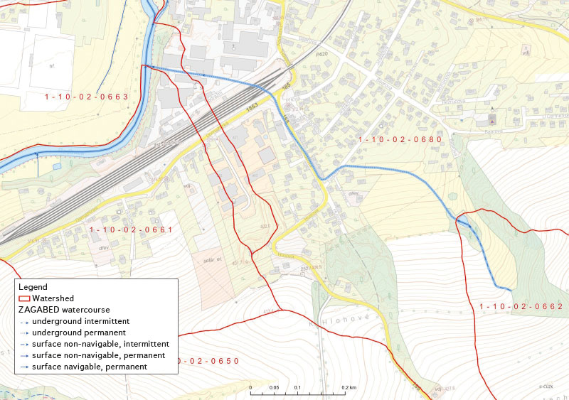
Fig. 1. Example where the drainage divide respected an underground section of a watercourse (dotted blue line)
Use of the rainfall-runoff model for storm sewers in Prague
One of the impulses for updating the watersheds in the capital city of Prague, taking into account the storm sewer network, was the request of City of Prague to create a rainfall-runoff prediction model of Prague on small watercourses, and also the request of some customers to use the obtained data on the capacities of the sewage system when issuing hydrological data (N-year and M-day flows).
Pražská vodohospodářská společnost, a. s. (PVS) has its own hydraulic rainfall-runoff model built over the structure of the sewage network of Prague and the wider surroundings, where the basic input spatial units are polygons corresponding to the basic sections of the sewage network (Fig. 2). These polygons are derived separately for rainwater and unified sewerage in places where the sewerage networks are separate. There were therefore designated areas for draining rainwater into the sewers, especially where separate sewers exist, mainly in the peripheral parts of Prague. In the centre of Prague, rainwater is drained by a unified sewerage network into the main sewers, of which there are seven in total, and then to the Central Wastewater Treatment Plant (CWWTP) in Prague-Troja. In Fig. 2, the water from catchments 1-12-02-0034-0-00-00 and 1-12-02-0035-0-00-00 is diverted to the CWWTP, the other catchments belong to the Rokytka and Hostavický streams.
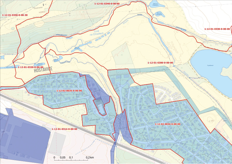
Fig. 2. Example of respecting the sewer drainage in the Prague-Hostavice and Dolní Počernice location in the derivation of the 4th order watersheds; the drainage divides follow the area from which the outflow is streamed to the rainwater sewerage
Foreign watersheds
The watersheds of primary catchment areas do not end at the state borders of the Czech Republic; they extend into neighbouring states. Part of the area is drained from abroad to the Czech Republic (e.g. the upper section of the Ohře, Lužnice, Dyje, and Olše), or only a small part of the foreign catchment lies within the Czech Republic (this concerns all border catchments with Poland, Germany, Austria, and Slovakia). In 2023, it was possible to obtain watershed data from all surrounding countries, but with different levels of details and degree of being up to date (Fig. 3). As part of the update of the watersheds, it was therefore necessary to check and correct the connection of our watersheds in cooperation with a selected foreign partner, which was done with as much consideration as possible to preserve the alignment of the provided foreign watershed and at the same time so that the watershed in the Czech Republic corresponds as much as possible to DMR 5G. The closing profiles of catchments flowing from the Czech Republic across national borders were also unified.
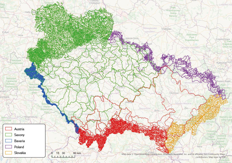
Fig. 3. Map of provided foreign drainage divides
Publication of new watersheds
The update took place in the most detailed data set of fourth-order watersheds; other orders and sub- catchments are subsequently generated from this data set based on attributes (number of hydrological sequence/ČHP, sub-catchment flag). Fourth-order catchment attributes also contain information about the structural model of watersheds, i.e. information on the source and following catchments, the size of the area of the given catchment, the total area of the catchment from the source, the name of the main stream in the catchment, and more.
The updating of watersheds based on the most current and most detailed data has resulted in a more precise alignment of the dividing line between two catchments, especially in lowland and flat areas, compared to watersheds at a scale of 1 : 10,000. Changes in the catchment area are most evident in small catchments and sub inter-catchments, with the increasing total area, the differences between the old and new area are smaller or negligible (unless there have been structural changes linked to structural changes of watercourses). Separately, no-runoff areas of the lignite mines of Ore Mountain foothills were delineated with quantitative determination of water transfers to the surrounding natural recipients, which results in a change in the size of the area of the Ohře basin, or Labe. A more detailed layer of watercourses leads in some cases to the further division of catchments and the creation of new ČHP.
The watersheds separating primary catchment areas reflect the situation under normal, average runoff. During floods, the drained area can vary (even quite significantly). The new watersheds are available to the public from 1st July 2024 at the following address: https://open-data-chmi.hub.arcgis.com/.
This informative article has not been peer-reviewed.
