ABSTRACT
The paper discusses changes in of the basic parameters of surface water within the important drinking water source area of hydrogeological unit 232 Ústecká syncline, in the Svitava river basin. Emphasis is placed on the changes in the amount of water in the Svitava river and the changes in the basic physical and chemical parameters of these waters. The possible effect on local groundwater, which is intensively used for drinking purposes, is discussed. The contribution compares historical data sets with the results of current monitoring within the project SS06010044 (PPŽ VI, TA CR). The current qualitative state of surface water points to caution in promoting direct infiltration into groundwater due to the risk of contamination.
INTRODUCTION
Monitoring surface water status is a long-term task that is often influenced by the contemporary mindset of society and its interests. Changes in the environment and the effects of human activity manifest themselves very well and often very quickly in surface waters, streams or reservoirs, which can be quickly documented, measured and analysed. At present times of significant environmental changes, there is often a discussion about the quantity and quality of water, where the interests and opinions of many groups collide and it is often problematic to reach a consensus. However, it is necessary to constantly monitor water status and strive for the best possible status in general, regardless of the specific use.
A much-discussed topic is “water retention in the landscape” [1]. Many professional workplaces and research projects have been dealing with this topic for many years, and the topic is part of national and international strategies to combat the negative impacts of climate change [2, 3]. There are many approaches and recommendations to help with water retention in the landscape, such as the Catalogue of semi-natural measures for water retention in the landscape [4]. However, in general we can say that the more stable and healthy the landscape is, the more water the landscape can retain on its own. From this point of view, agricultural and forest land and their management are increasingly monitored. The condition of these soils is unsatisfactory in many parts of the Czech landscape [5] and action is needed. In the case of surface water quality, it is important to address the intensive use of fertilizers (both artificial and natural), cultivated crops, and large livestock farms. An interesting issue is the amount and extent of meliorated land within the agricultural area in the Czech Republic [6], which is relatively little discussed, but which is important from the point of view of water quantity. It is logical that if we have extensive areas that are meliorated, a large amount of water drains away from the area at an accelerated rate, and there is also an accelerated movement of contaminants, which then spread in watercourses and are deposited in reservoirs. Not to mention the fact that in such a case, the application of measures to retain water in the landscape is almost not worth the effort.
From the point of view of long-term water status monitoring, the least complex is water amount measurement, or water level, which can then be converted to water volume, both in watercourses and in reservoirs. There are many monitoring points and they are mainly managed by CHMI [7], Povodí state enterprises, and other entities. The situation regarding the monitoring of water quality parameters is a bit more complicated; it is mainly due to the complexity of the measurements and the necessity of taking water samples, which must then be processed in a laboratory, and which greatly limits the possibilities of continuous measurement (such as is the case of water level). However, information on water quality is crucial if we want to evaluate the impact of human activity on industry, agriculture, waste management, transport, etc.
The selected research area of hydrogeological unit 4232 Ústecká syncline in the Svitava river basin is an example of a natural system that is an important source of high-quality groundwater for human consumption and, at the same time, the impact of human activity on these clearly definable resources can be assessed here: intensive agriculture, industrial activity (especially in the last century), the influence of settlements and transport. From a hydrogeological and hydrological point of view, the area is made up of a closed system, where all rainwater drains away through a main surface watercourse – the Svitava [8, 9]. From the point of view of hydrological balance, the runoff conditions here are strongly influenced by groundwater pumping, namely in the vicinity of the town of Svitava and especially in the Březová nad Svitavou water resource, from where the water is diverted by long-distance water supply to the city of Brno [10]. The high rate of groundwater pumping, together with the accelerated runoff from the area due to land reclamation and the influence of increasing weather extremes (heavy rains vs draught), cause a large decrease and fluctuation of water in the monitored area. This is most evident in the growing season, when there is the greatest pressure on water resources; for example, the river Svitava itself loses its water level even before it flows into the town of Svitava. Nowadays, there they often speak (in a sarcastic manner) about the “new spring of the Svitava at the Hradec nad Svitavou WWTP”. During this period, the water quality in watercourses also drops significantly.
In addition to a change in management or a reduction in water consumption, other options are being sought to reverse this situation. In recent years, the possibility of restoring watercourses (which are largely in artificial stone-concrete channels) has been discussed in connection with this area. The most significant changes were made in the 1970s during the construction of the second Březová water supply system; a 6km stretch of the Svitava river was reinforced between the towns of Hradec nad Svitavou, Březová nad Svitavou, and Banínský stream. These measures were taken due to the danger of water contamination at the Březová nad Svitavou headwater with highly polluted waters from intensive industrial production and municipal waters [11].
The recent dry period (2015–2018) also focussed attention on surface water and groundwater relations in the groundwater source area. Efforts to increase groundwater supplies by means of simplified and supported direct infiltration are hindered by insufficient knowledge about the local quality of these waters and related concerns about introducing unwanted contaminants into underground collectors used or protected for human consumption. In the long term, an increase in nitrates and pesticides in groundwater [12–14] has been monitored; its origin is assumed to be mainly from agricultural activity. Pesticides are also gradually appearing in the water supply network [15], which is very problematic.
In the area of interest, the groundwater status is relatively well monitored (both in terms of quality and quantity) for at least a hundred years in connection with the use of water in the Březová spring [10]. Surface waters are monitored rather sporadically, or systematically with a purpose to monitor the impact of the use of the headwater on the Svitava downstream. The observance of minimum flows is emphasized in the Svitava river below the headwater and further downstream during the flow through the industrial towns of Blansko, Adamov, and Brno in particular. The proposed monitoring (or rather screening) of surface water quality in the area of interest is intended to alleviate this lack of knowledge.
METHODOLOGY AND AREA DESCRIPTION
For the needs of the project and the fulfilment of its goals, eleven locations were selected for surface water sampling from the Svitava and its main tributaries (Fig. 1). The Svitava is the main stream of the hydrogeological unit 4232 Ústecká syncline in the Svitava river basin research area (hereinafter referred to as the HG unit). The HG unit mainly covers the Pardubice region and partially extends into the South Moravian region (the southern edge of the HG unit). The area ranges between 400 (southern part) and 650 metres above sea level (eastern and western edges). The total size of the HG unit is 358 km2. It is oriented in a north-south direction and is an example of the eastern edge of the continuous occurrence of Cretaceous sediments in the Czech Republic. The HG unit composition is determined by the alternation of permeable hydrogeological aquifers (sandstones) and impermeable hydrogeological insulators (claystones) [8, 9], thanks to which important groundwater sources are formed in the area, used mainly for drinking purposes [10, 16, 17].
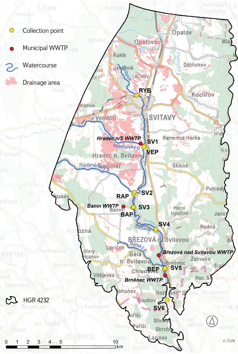
Fig. 1. Location of collection points within hydrogeological unit 4232 Ústecká syncline in the Svitava river basin (further information in Tab. 1)
From the point of view of land use, the hydrogeological unit is mainly made up of agricultural land (about 40 %), which are found on flat land around watercourses in the upper to middle part. Forests (about 35 %) are also significant, mostly found on hills on the edge of the area and in the southern part, where the Svitava and its tributaries are deeply incised in the surrounding terrain. Permanent grasslands (about 13 %) and built-up areas (about 11 %) occupy a similar amount, while the built-up areas are clearly linked to watercourses (with the exception of the town of Svitava, the municipalities are very long and often interconnected). There are very few water bodies (about 0.3 %), located in the northern part of the area. More detailed information about use of the area and its development over the last 200 years can be found in [17].
There are also relatively large areas of drained agricultural land (Fig. 1). The main part is in northwest of the research area, between the towns of Opatov, Svitavy, and Hradec nad Svitavou. Some land reclamations are over 100 years old, but the majority were created in the second half of the 20th century [6]. According to a field survey, the reclamation facilities are still functional in many places.
The Svitava forms the mail stream of the area and, in the northern part of the HG unit, has extensive headwater, which is heavily waterlogged throughout the year. With the exception of the Lačnovský stream (confluence in Svitavy) and Chrastovský stream (confluence in Moravská Chrastová), all significant tributaries of the Svitava are right-hand. These include the Vendolský stream (confluence in Hradec nad Svitavou), Radiměřský stream (confluence at the end of Radiměř village), Banínský stream (confluence above the Březová nad Svitavou water resource) and Bělský stream (confluence in Brněnec village). At the confluence with the Svitava, ten collection points were established (Tab. 1) where surface water sampling has been taking place in monthly increments since June 2023. These sites are complemented by a collection point on the Svitava pond, above the town of Svitavy, which collects water from the entire headwater of the Svitava river.
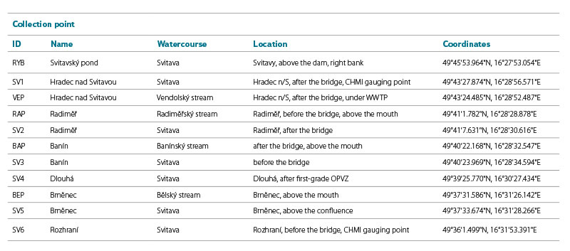
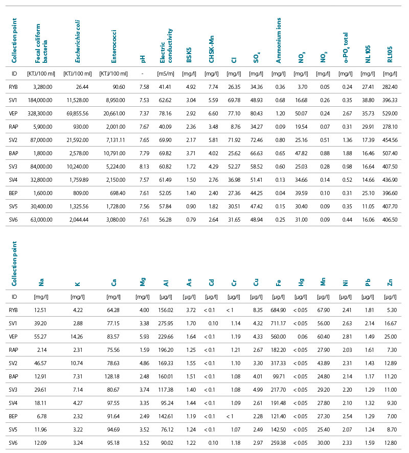
Tab. 1. Description of surface water collection points
The selection of locations took place in the field after consultations and with the participation of researchers working on the project. Subsequent sampling was carried out by a sampler with appropriate accreditation. Basic chemical analyses and microbiological analyses were carried out at the TGM WRI laboratory in Brno, and the results of the individual tests are part of the laboratory’s standard work. In the following part of the text, we process and present only those indicators that are relevant to the project’s goals.
RESULTS AND DISCUSSION
Change in runoff conditions and impact on water resources
In the following graphs in Fig. 2, the annual trends of average monthly flows are drawn for comparison, always with an interval of ten years. The grey background area represents the long-term monthly average for 1981–2023. In both profiles, the Svitava is characterized by an increased flow in the spring months, especially in March. This can be related to snowmelt, spring rains, and agricultural land without vegetation which enables greater surface runoff. This spring “peak” is also shown by almost all other curves in the graph for the years under review, but sometimes with a shift to the following spring months. The second, albeit lower peak in the long-term average is no longer visible in the following monitored years; the effect of long-term intensive precipitation often occurs at the beginning of July (e.g. 1997 in Moravia). In July, there is the most significant change compared to the long-term average. The other seasons (the end of summer and autumn) have always been the period of lowest flows, and the monitored years are almost all below this long-term average.
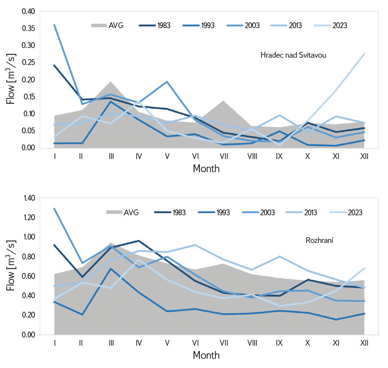
Fig. 2. Average monthly flow [m3/s] of the Svitava river at the Hradec nad Svitavou station and the Rozhraní station (stations operated by CHMI), 1981–2023
In recent years, a big drop in the level of the Svitava and its tributaries can often be seen, which of course is most evident in dry periods. Evidence of a decrease in the water level of the upper reaches of the river are the changes of the flow at the Rozhraní water gauging station (Fig. 3), where data from 1931 are available. It is clear that until 1970 there was rather an increasing trend and the average annual flow during this period was 1.35 m3/s. After 1981, there has been a big change in the flow, and in recent years it often falls below the average for this period, which is 0.69 m3/s. This change is associated with a higher rate of groundwater pumping in the upper part of the basin, primarily for water supply purposes. The rapid decline in the 1970s is mainly associated with the construction of the second water supply system in Březová for the city of Brno. The changes in annual precipitation totals at the Stvolová station can also be seen in Fig. 3, where a slight decrease in recent years is visible, although this change is not significant. From this, it can be concluded that groundwater pumping has a much greater influence on the decrease in the Svitava flow.
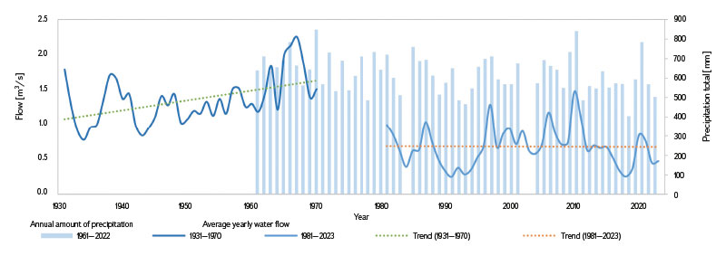
Fig. 3. Average yearly water flow [m3/s] of the Svitava river at the Rozhraní station, and the annual amount of precipitation at the Stvolová station (stations operated by CHMI), 1931–2023
The above analysis indicates the issues that can be expected in the future. There are already groundwater limit levels [18] that must be maintained. If the actual level is close to the set limit, the use of resources will be restricted. If a dry period of several years occurs again, its effects may be more pronounced than now. As the graph in Fig. 3 shows, the dry period of 2015–2018 was preceded by relatively rain-rich and aqueous years.
Changes in surface water quality
The development of water quantity and quality in the upper reaches of the Svitava is specific. Historically, the town of Svitavy had one of the first sewage networks in our country [19]. However, wastewater was discharged directly into the watercourse without treatment. Even after the wastewater treatment plant (WWTP) in Hradec nad Svitavou was put into operation, some parts of the town were connected to it very slowly [11]. No WWTP is capable of treating water economically to the level of an unaffected natural state. A certain dilution with water from the recipient is always taken into account, as well as the self-cleaning ability of the watercourse [20]. From the point of view of our topic, it should be mentioned that there are 50 settlements in the area of interest and only four WWTPs, according to the DIBAVOD database and other documents (and not all of them are in operation). This is due to the local situation; municipalities tend to be connected to a combined sewerage network, for example the Svitava sewerage network leading to the WWTP in Hradec nad Svitavou. This also corresponds to the data on “Discharges into surface waters” from the ISVS – VODA database (www.voda.gov.cz), where only five discharge sites are registered within the research area, while four are from local municipal WWTPs (Fig. 1) .
The following summary in Tab. 2 shows average values from the data detected by monitoring for selected parameters. These average values of indicators provide a clear picture of the area of interest in terms of surface water quality. There are ten measured values (samplings), in the case of SV1 only six, and at SV2 nine samplings; in some cases, the flow of the Svitava itself was completely zero and it was not possible to take a sample.
From the point of view of microbiological indicators, the worst-rated place is VEP, the recipient of treated wastewater from the town of Svitavy. In the following places on the Svitava, it is noticeable that the values gradually decrease. None of the tributaries reach such high values. It can therefore be concluded that the Svitava (Hradec) WWTP affects the Svitava river in this direction along the entire monitored length. Only the last monitored profile SV6 deviates from this trend; there is a deterioration compared to the previous location (SV5). This can probably be attributed to municipal pollution from Brněnec, Moravská Chrastavá, and other parts of the municipalities, where the built-up areas approach the river and the disposal of wastewater has not yet been satisfactorily solved.
Similarly, it is possible to evaluate other indicators from the first part of Tab. 2; at BAP, the influence of water from the treatment plant on the Banínský stream (WWTP of Banín municipality) is more pronounced. This fact is also significant because Banínský stream directly connects to the Březová catchment area in its final section, and in recent years there have been efforts to restore the watercourse [21]. Somewhat surprising are the high NO3 values at VEP and BAP. Nitrate loading is mostly attributed to agricultural pollution [11–14]. In the monitored case, however, it is also associated with increased values of ammonium ions and may thus indicate that the efficiency of nitrogen degradation at both WWTPs is not high. Other tributaries of the Svitava indicate a rather widespread and diffuse water load. However, these pollutants would manifest themselves more significantly in the water during sudden increased flows in the event of torrential rain, which could not be detected within the described monitoring.
RYB stands out from the entire set of collection points in many indicators. Since it is a sampling of pond water, other biological processes affect its quality. From the indicators in Tab. 2, it is possible to prove it, for example, by low concentrations of nitrates, even though intensively used arable land predominates in the catchment area above the pond. Reduction of nitrogen concentrations in stagnant water is caused by chemical oxidation-reduction processes and the use of nitrogen by green organisms. Phosphorus concentration, which enters the water mainly through runoff from fields, is the lowest in the pond among the monitored locations. Nevertheless, it is high enough to allow the massive development of cyanobacteria if other conditions are met. Monitoring and studying these natural events is interesting in itself. However, the site was included in the monitoring in order to obtain background natural values of water quality when entering the monitored system. However, due to almost zero outflow from the pond for most of the monitoring period, this was not achieved.
Some indicators from the second part of the table are favourable in the entire basin. These are, for example, cadmium and mercury, which were below the detection limit or randomly just above it in all samplings. Other heavy metals such as chromium, nickel, and lead are below the limits established for these substances in all samples [22].
Tab. 2. Average values of chosen parameters of surface water
For some important indicators, the monitoring data were processed in more detail. Figs. 4–9 show the results of the basic statistical analysis of selected parameters of surface water at individual sampling sites; the thin lines show the dispersion of values (MIN and MAX), the lower limit of the box shows the value of the first quartile, the upper limit of the box shows the value of the third quartile, and the interface between the light blue and the dark blue box shows the median value. All samplings were carried out during average or rather lower flows; the situation after torrential rainfall or during a longer period of increased status was not recorded. The variability of pollutant concentrations described below is thus most probably caused by the seasonality of agricultural work, or by fluctuations in the efficiency of treating processes at the WWTP.
Fig. 4 shows the statistical evaluation of detected values of electrical conductivity. The first RYB site represents a natural background in the basin above the town of Svitavy, unaffected by point pollution. This site also has the lowest concentration fluctuations. The conductivity of the Radiměřský stream, which also represents a separate small basin, unloaded by external influences, has a similar character. The collection point SV1, on the other hand, shows the highest MAX value and, at the same time, the largest deviation of this value from the median. This is a site below the town of Svitavy, where the smallest number of samples could be taken due to insufficient flow. The measured values rather document the sudden flow of wastewater or the displacement of contaminated sediments.
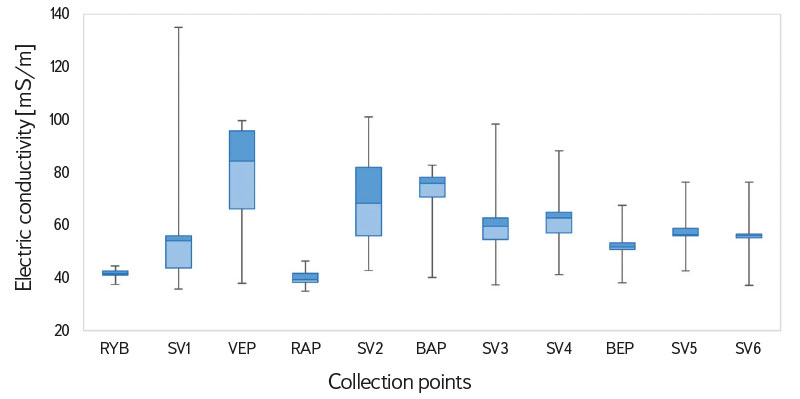
Fig. 4. Variance of values of electric conductivity [mS/m], June 2023 to March 2024
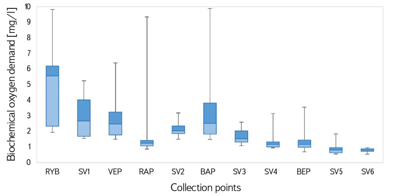
Fig. 5. Variance of concentration values of biochemical oxygen demand [mg/l], June 2023 to March 2024
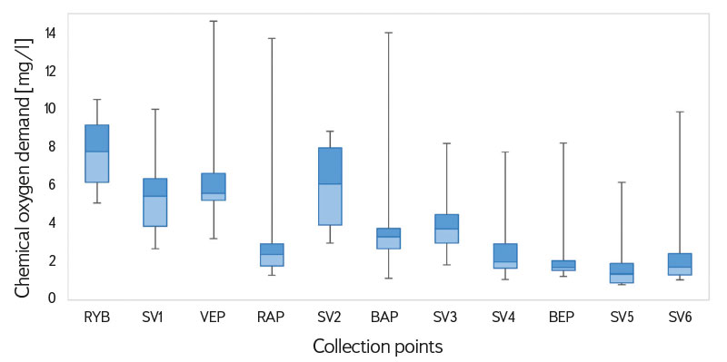
Fig. 6. Variance of concentration values of chemical oxygen demand [mg/l], June 2023 to March 2024
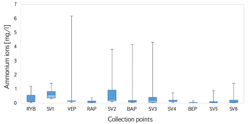
Fig. 7. Variance of concentration values of ammonium ions [mg/l], June 2023 to March 2024
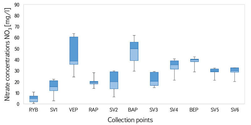
Fig. 8. Variance of concentration values of nitrates (NO3) [mg/l], June 2023 to March 2024
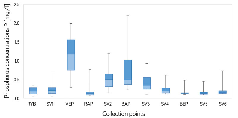
Fig. 9. Variance of concentration values of phosphorus (P) [mg/l], June 2023 to March 2024
The variance of phosphorus concentration values in the monitored streams clearly shows the influence of municipal pollution when wastewater passes through the treatment plant (see Fig. 9, VEP and BAP). The loaded stream waters affect the flow of the Svitava itself, where the phosphorus concentration gradually decreases downstream (SV2, SV3, SV4 and SV5). The decrease is caused by gradual dilution by unloaded water, and by the transition of phosphorus into river sediments. Phosphorus itself is not an immediate danger to the watercourse, but it again shows the greatest fluctuations and the highest peak values in the streams in places below the WWTP. This may indicate lapses in treatment efficiency in these devices and may also relate to other more serious quality indicators.
CONCLUSION
Groundwater in the Svitava part of the Ústecká syncline is one of the largest reservoirs of usable water in the Czech Republic. A comparison of historical and current data on flows in the Svitava shows a clear connection between the watercourse status and the amount of groundwater abstracted. If pressure on the amount of water abstracted for drinking purposes increases, stricter limits for the sustainability of this resource must be expected in the future.
Groundwater quality is directly related to surface activities and surface water quality. This must also be considered when designing restoration and other measures to retain water in the landscape. Although there is a certain time delay in the manifestations of the effect on groundwater, constant attention must be paid to the quality of surface and drainage waters. So far, relatively little data is available on surface water quality in the research area, especially in the case of extreme weather conditions. In the future, it would be advisable to carry out more detailed time monitoring to capture such events.
Comprehensive monitoring of surface water quality showed considerable seasonal variability. Although the measured values are not a sign of emergency state, it is recommended to continue similar monitoring, including in other places and with the extension to drainage waters of meliorated areas of agricultural land. Although the results of surface water monitoring show a significant improvement in quality compared to the conditions at the time of the construction of the second Březová water supply system, it is highly desirable to leave and repair the impervious treatment of the bed of the Svratka and Banínský streams in direct connection with the Březová headwater. This is not only protection against significant accidental pollution from industry or transport; it is becoming obvious that even minor shortfalls in the efficiency of some of the WWTPs will have a significant effect on the quality of water in the Svitava over a long stretch.
Acknowledgements
The paper was created within the framework of research project SS06010044 “Defining and evaluating areas decisive for subsidizing strategic groundwater resources with regard to their protection and stabilization” (Environment for Life VI, Technological Agency of the Czech Republic).
The Czech version of this article was peer-reviewed, the English version was translated from the Czech original by Environmental Translation Ltd.
