SUMMARY
This article deals with changes in wetlands on the north-eastern edge of Hřebeny Mountains in the last 180 years. It assesses the dynamics of these landscape elements in space and time. The cadastral areas of Čisovice, Řitka, Kytín, and Nová Ves pod Pleší were selected, with a total area of 3,785.57 ha. Analysis was carried out on the basis of the Imperial obligatory prints of the maps of the stable cadastre from 1840, an orthophotomap, and field research from 2020; it distinguished wetlands in the monitored area into continuous, extinct and new. The background data were processed in ArcGIS software, version 10.7.1. The area of wetlands decreased from 289.34 ha in 1840 (7.6% of the monitored area) to 39.26 ha in 2020 (1.04% of the monitored area). Based on the study of available data, three types of wetland habitats were classified: wet meadows, wet meadows with woody plants, and ponds.
INTRODUCTION: LANDSCAPE CHANGES IN THE CONTEXT OF WATER MANAGEMENT
The landscape is constantly changing, most often as a result of human activity. The European landscape underwent major changes during the early 19th and during the 20th century – from the intensification of agricultural production, to the construction of urban and suburban zones, to reforestation [1]. The landscape in the Czech Republic is no exception. Over the past 200 years, there has been a permanent loss of meadows and pastures from the landscape, most often in order to create new arable land. In the 19th century, even meadows in floodplain areas were ploughed in this way [2]. Between 1845 and 1948, meadows and pastures were the most common original land used for the creation of new arable land. This trend of steady decline changed in the 1990s, when meadows and pastures were extended, first in mountainous areas and then in the lowlands [3]. During the 19th century, further interventions in the landscape took place on surface waters. For the first time in history, large-scale land reclamation, straightening and regulation of watercourses, infilling of ponds, and construction of the first dams took place [2]. Ponds are man-made wetlands. They were established in Bohemia from the 12th century, but their decline began after the Thirty Years’ War, and new pastures and fields were created on dried up areas [4]. In the Czech Republic, the term pond is defined by Act 99/2004 Coll., as “a body of water, which is a reservoir intended primarily for fish farming, in which the water level can be regulated, including the possibility of its discharge and fish harvesting; a pond consists of a dyke, a reservoir, and other technical equipment”[5]. One of the most important functions of wetlands in general is the ability to retain surface water, which is then released into groundwater, enriching its supplies. This connectivity between wetlands and groundwater is influenced by the geological subsoil, relief, and soil properties [6]. Replenished groundwater supplies are slowly released into the surrounding watercourses, reservoirs, and the landscape in general, thus providing the environment with a water supply in times of drought [7]. The main goal of the research presented in this article was to assess the spatiotemporal dynamics of wetland habitats.
Monitored area
Brdská vrchovina (The Brdy Highlands) is divided into Hřebeny, central Brdy, and southern Brdy [8, 9]. Brdská vrchovina also include the sub-units Příbramská pahorkatina and Brdy itself, consisting of three districts (Třemošenská vrchovina, Třemšínská vrchovina, and Strašická vrchovina) [9]. Hřebeny, sometimes called Brdské Hřebeny or Hřebeny Brdy, represent a forested belt stretching in the NE-SW direction between Prague and Pilsen, more specifically between the Vltava valley, near Zbraslav, and the Litavka valley. In 2009, Hřebeny Nature Park was designated in the majority of Brdy Hřebeny, covering 184 km2 [10].
An up-to-date geomorphological division:
- GMF subsystem: Brdy subsystem
- GMF unit: Brdská vrchovina
- GMF subunit: Brdy, Hřebeny, Příbramská pahorkatina
Hřebeny subunit is located in the north-eastern part of Brdská vrchovina. It is a rugged highland with an area of 125.08 km2, a mean height of 440 m, and a mean slope of 7°. It is composed of formations of Cambrian and Ordovician shales, sandstones, greywacke, conglomerates and quartzites, Proterozoic dacites, andesites and tuffs; these form a single wide structural ridge of the SW-NE direction with significant steep marginal slopes (covered with boulder and block rubble on the NW), transversely disturbed by the Vltava valley and Všenorský potok. The highest point is Studený vrch, at 660.30 m above sea level, in Studenská vrchovina [9].
The monitored area was delimited by the boundaries of the current cadastral areas (hereinafter c. a.) (Fig. 1). It was chosen to represent predictors of the development of watercourses and wetlands in the landscape area “Dobříšsko-Mníšsko”, located on the north-eastern edge of Hřebeny [11]. The main criterion for the selection of the monitored area was its location in the hitherto little-analysed area of Central Bohemia, in the geomorphological subunit Hřebeny. Another criterion was the location of the study area in a moderately cold landscape of hills and highlands [12]. The local landscape is a mosaic of forests, large agricultural fields, and smaller settlements. It also serves as an important leisure facility for the capital city of Prague [13].
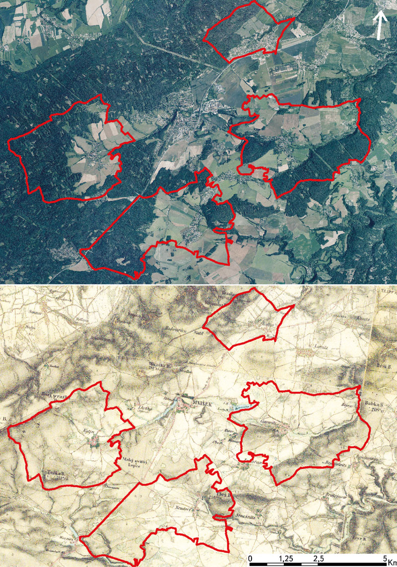
Fig. 1. Monitored area (current borders of cadastral area) on the basis of the current orthophotomap [21] and 2nd military mapping (mapped 1836–1852, 1 : 28,800) [22]
Four c. a. were selected, with a total area of 3,785.57 ha [14]. The natural topographical and economic centre of the area, Mníšek pod Brdy c. a., was intentionally omitted from the selection. Mníšek pod Brdy has had the status of a town since the 14th century [15]. Its character does not correspond to the rural type of settlement, and its territory is therefore not suitable for comparison with the surrounding rural regions.
The imaginary axis of the monitored area is the D4 motorway leading from Prague in a south-westerly direction; its route approximately follows the route of the historic Golden Trail. The Golden Trail from Prague to Passau had a major impact on the cultural development of the local landscape. Historically, the area belonged to the prince and later royal states. Continuous forest stands predominated here, in which the royal hunting lodges were located (the current chateau in Mníšek pod Brdy, Vargač in Dobříš, Tři Trubky near Strašice, etc.). A number of plots of land in the vicinity of Mníšek pod Brdy came into the ownership of the church as a prince or royal gift. Monasteries colonized the area and established villages. The monitored area thus belonged to the later colonized areas of the middle Povltaví [16].
Over the past twenty years, new construction has multiplied due to good connections, clean air, and proximity to Brdy Hřebeny. The population almost doubled from the beginning of 2001 to the end of 2020 (Čisovice: 703 inhabitants => 1,104 inhabitants; Řitka: 604 inhabitants => 1,228 inhabitants; Kytín: 331 => 543 inhabitants; Nová Ves pod Pleší: 731 => 1,286 inhabitants) [17].
The original agricultural character of the c. a. in the monitored area was replaced by a residential and recreational function. The historically predominant arable land gave way to new urban and suburban development. At present, a minimum of the population is tied to agriculture, most of them commute to work, and a significant part of the development is used for recreational purposes [11].
Description of the monitored area in terms of geomorphology, climate, vegetation, and water in the landscape
- Geomorphology: weaker layers of loess clays deposited on the gentle slopes of predominantly south-eastern orientation, transferring into slopes. These soils are more fertile, which is why they have been mostly ploughed. The incision of the Vltava tributaries (Bojovský potok, Novoveský potok, Voznický potok) and Berounka tributaries (Všenorský potok) are more pronounced in places [11].
- Climate: the climate is moderately warm and moderately dry. The western half of Central Bohemia lies in the rain shadow of the Brdy Mountains, or the Ore Mountains, and the study areas of interest also lie in the rain shadow of Hřebeny. The climate of the region is also influenced by relatively warm drying winds (slight resemblance to Föhn winds). The average annual air temperature is 7–9 °C, with average annual rainfall of 500–600 mm [18].
- Vegetation: the phytogeographical perimeter of the area is the Bohemian-Moravian Mesophyticum, phytogeographical district 35c Příbramské Podbrdsko – it forms a transition between thermophilous and psychrophilic flora; it includes the supracolinic (hilly) and submontane (foothill, highland) layer [19]. Spruce is the dominant tree species in commercial forests. On the southern slopes of Hřebeny, it suffers from drought in places, which means that it is more exposed to bark beetle attack. Spruce monocultures are supplemented by pine, fir, and larch. Oak, beech, aspen, birch, and maple are represented, individually or in groups, sometimes also in continuous stands [11].
- Water in the landscape: aquatic ecosystems are not an important feature of the landscape. They consist of small and large streams, small to medium-sized ponds, and springs. Streams flowing through the field landscape are often regulated, channelled, and usually with a minimum of riparian vegetation. The streams flowing through the forest landscape were also subjected to channelling and incision, but they mostly retained their near-nature character. Numerous springs in the fields were drained and disappeared. There are few springs in the forests; they are mostly located at the foot of Hřebeny in waterlogged localities. Here, too, many have been drained [11].
METHODOLOGY
The basis for data processing were archival map data, map data from 2020, and field research carried out during 2020. The actual processing of the obtained data took place in 2021.
Documentation for data processing
The basic documents for the creation of a vector layer for the analysis of the development of the monitored area were map sheets of the Imperial Mandatory Imprints of the Stable Cadastre (showing the state of the area in 1840 at a scale of 1 : 2,880) [20] and a coordinated orthophotomap from 2020, ZABAGED® and Basic Map of the Czech Republic 1 : 10,000 (BM 10), all available on the ČÚZK Geoportal [21] as a WMS service.
Programs used and data processing
Georeferencing of archival map sheets of the Imperial Mandatory Imprints of the Stable Cadastre in the S-JTSK East North coordinate system, connection of current documents using the WMS service, and subsequent creation of a polygon layer of the .shp format took place in the ArcGIS environment, in the ArcMAP 10.7.1 program. Each polygon was defined by its identification number, the type of wetland, and the year in which it occurred in the area. The initial data processing took place in a GIS environment. It was a calculation of the area of polygons and line lengths. The resulting values were exported and interpreted in the form of tables in Microsoft Excel 2016. As part of the processing of these map and tabular outputs, the article presents results concerning the change in area and location of individual types of wetlands. According to stability, wetlands were differentiated as continuous, defunct, and new (Tab. 1). Based on available data, three types of wetland habitats were classified: wet meadows, wet meadows with woody plants, and ponds (Tab. 3); it was thus possible to identify them in both monitored periods.
Tab. 1. Wetland classification according to stability occurrence in individual periods
Determining the hypothesis of landscape changes in the monitored area and the expected driving forces
A hypothesis of a significant decrease in wetlands was established in connection with the change of land use from purely agricultural to predominantly urban, and to the intensification of agriculture in the remaining cultivated areas. The set of impulses that leads to such changes in the landscape is called the driving forces. The concept of land use driving forces is the basic term used to explain the reasons for landscape changes [24]. A characteristic feature of driving forces is their interconnectedness, diversity, and difficulty in defining them [25]. However, despite this diversity, driving forces tend to be divided into different categories. The basic division of driving forces is into two categories, depending on the relationship of their origin to human society, namely social driving forces and natural conditions [26]. Subsequently, social driving forces can be divided into four basic categories: economic, technological, political, and cultural [27]. The assumption was that the intensification of agriculture and urbanization in this area was the result of the first three above-mentioned driving forces; urbanization, due to the recreational use of the area, was also influenced by cultural driving forces.
RESULTS
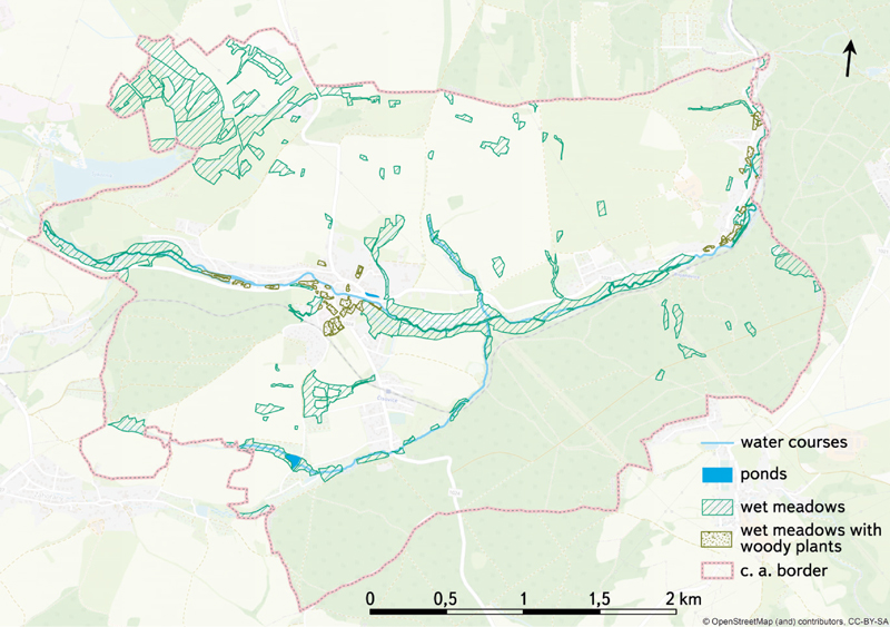
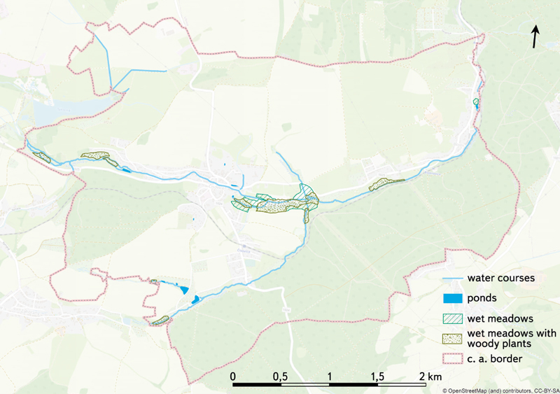
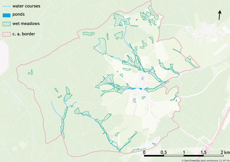
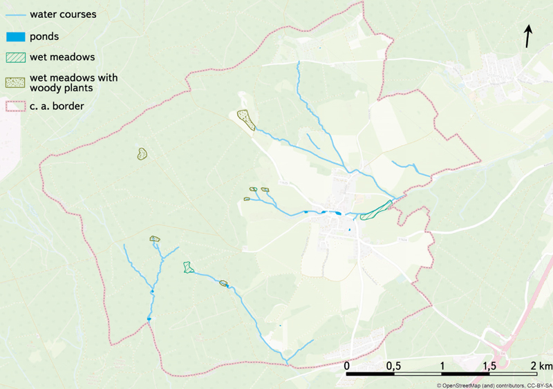
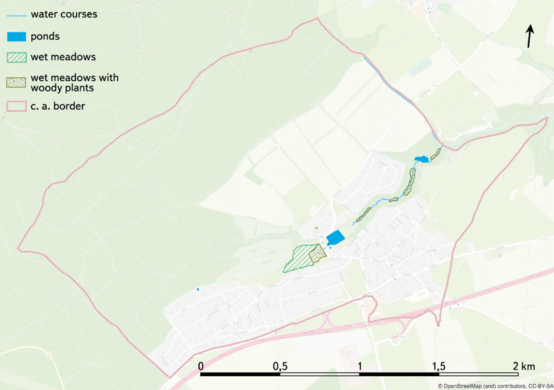
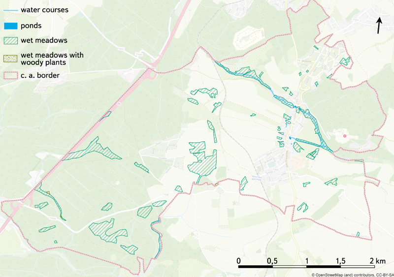
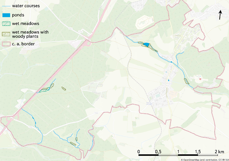
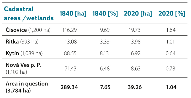
A common feature of all studied c. a. is a significant decrease in the total area of wetlands – it decreased from 289.34 ha in 1840 (7.6% of the monitored area) to 39.26 ha in 2020 (1.04% of the monitored area) (Tab. 2, Fig. 2–9). The most dominant wetland type (out of all types according to stability, i. e. including defunct wetlands) in the monitored area are wet meadows – they cover 283.87 ha, i. e. they make up 89.35% of wetland types. Wet meadows with woody plants and ponds are located only on 27.92 ha, or 5.91 ha, i. e. it makes up 8.79%, or 1.86% of wetland types.
Tab. 2. Total proportion of wetlands in individual periods in absolute [ha] and relative [%] values
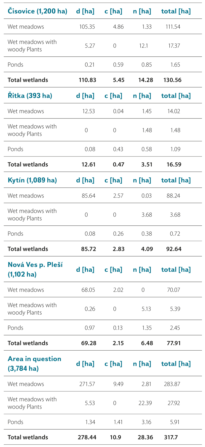
Wet meadows according to stability significantly predominate – the defunct ones have an area of 271.57 ha (95.67%), while continuous and new meadows occupy 9.49 ha (3.34%), or 2.81 ha (0.99%).
On the other hand, minor wetland types (i. e. wet meadows with woody plants and ponds) record an increase in their total area over time; however, due to their small proportion in the monitored area, they cannot reverse the overall trend for wetlands given by predominant wet meadows.
According to stability, new wet meadows with woody plants predominate – on an area of 22.39 ha (80.19%); in contrast, defunct ones occupy 5.53 ha (19.81%). As a continuous type of wetland according to stability, wet meadows with woody plants do not occur. According to stability, ponds are mostly represented by new ones – on an area of 3.16 ha (53.47%), continuous and defunct ones occupy 1.41 ha (23.86%), or 1.34 ha (22.67%).
In all four c. a., the results and trends are similar to those in the entire monitored area, i. e. the largest area of defunct wetlands and the smallest area of continuous wetlands. However, there are minor differences; for example, in Řitka and Kytín c. a., wet meadows with woody plants occur only as new wetlands. As a continuous type wet meadows are almost non-existent in Řitka c. a. and have a smaller area than new wet meadows. The same applies to ponds in Nová ves pod Pleší c. a. In Řitka c. a., the total area of wetlands according to stability is considerably smaller than in other c. a. (4.7 times smaller than in Nová Ves pod Pleší c. a., 5.6 times smaller than in Kytín c. a. and 7.9 times smaller than in Čisovice c. a.). The entire area of Řitka c. a. is about 3 times smaller in relation to all other individual c. a. (Tab. 3, Fig. 2–9).
Fig. 2. Location of wetland habitats in the Čisovice cadastral area in 1840. Background data OpenStreetMap [23]
Fig. 3. Location of wetland habitats in the Čisovice cadastral area in 2020. Background data OpenStreetMap [23]
Fig. 4. Location of wetland habitats in the Kytín cadastral area in 1840. Background data OpenStreetMap [23]
Fig. 5. Location of wetland habitats in the Kytín cadastral area in 2020. Background data OpenStreetMap [23]
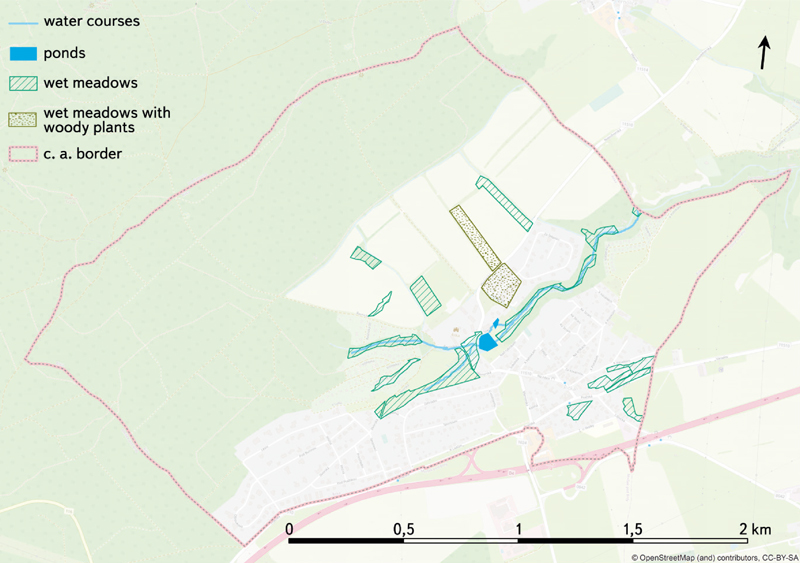
Fig. 6. Location of wetland habitats in the Řitka cadastral area in 1840. Background data OpenStreetMap [23]
Fig. 7. Location of wetland habitats in the Řitka cadastral area in 2020. Background data OpenStreetMap [23]
Fig. 8. Location of wetland habitats in the Nová Ves pod Pleší cadastral area in 1840. Background data OpenStreetMap [23]
Fig. 9. Location of wetland habitats in the Nová Ves pod Pleší cadastral area in 2020. Background data OpenStreetMap [23]
On defunct areas of wet meadows, i. e. the predominant wetland habitat, in Kytín c. a., permanent grasslands (42%), forest and shrubs (18 and 17%, respectively) currently occur most frequently; in Nová Ves pod Pleší c. a., the same applies for permanent grasslands (38%), arable land and forest (30 and 27%, respectively), and in Čisovice c. a., the same applies for permanent grasslands and arable land (40 and 28%, respectively); however, forest and development, including gardens on the site of defunct wetlands, also account for a significant share (14 and 13%, respectively). In Řitka c. a., on the site of wet meadows there are permanent grasslands (35%), forest and development, including gardens (both 27%), arable land (12%) and also a relatively significant area of defunct wet meadows with woody plants. On their site, arable land and development, including gardens, are equally represented.
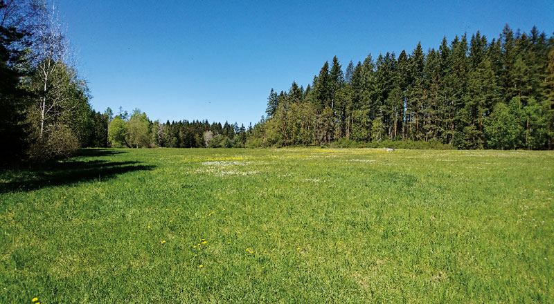
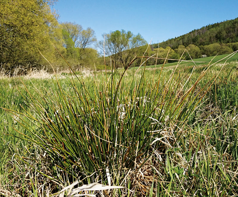
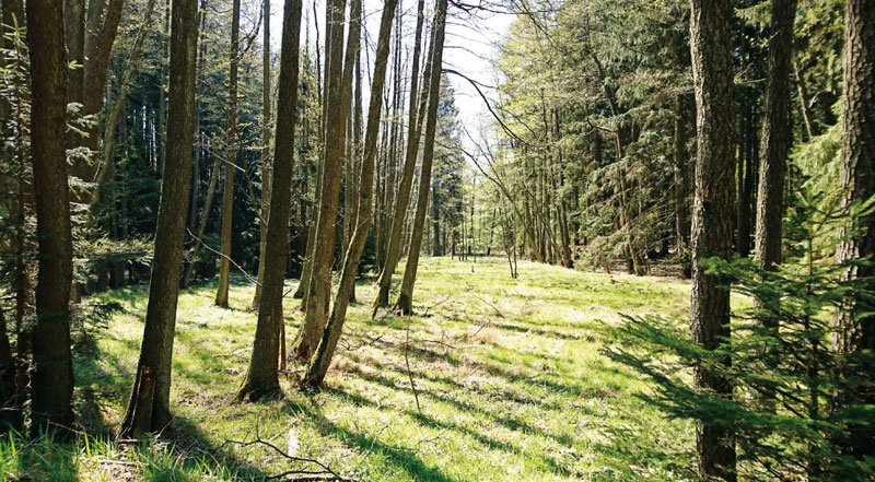
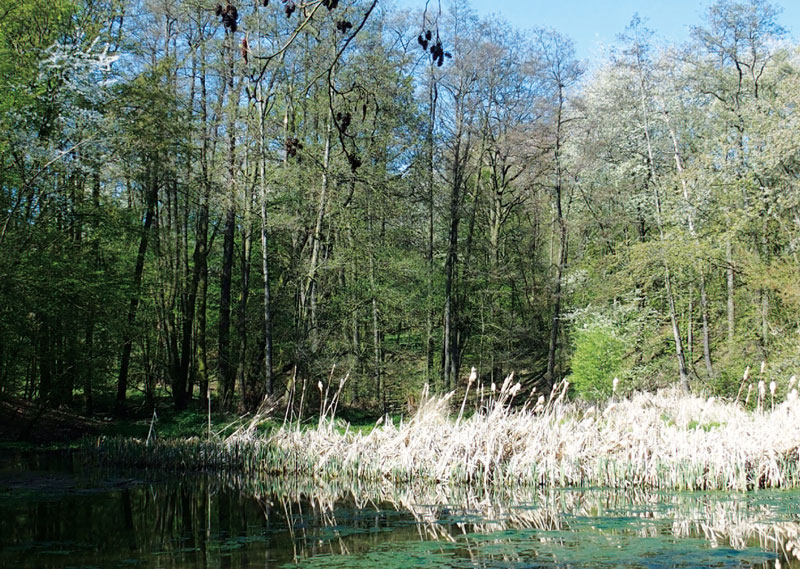
Fig. 10–13 present examples of wetland habitat types from field research in the monitored area.
Fig. 10. Wet meadow in the locality Andělské schody in the Nová Ves pod Pleší cadastral aea
Fig. 11. The wide floodplain of the Bojovský creek in the Čisovice cadastral area classified as a wet meadow
Fig. 12. The floodplain of the Chouzavá creek in the Kytín cadastral area classified as a wet meadow with woody plants
Fig. 13. The littoral zone of the Mlýnec pond in the Řitka cadastral area
DISCUSSION
Selected sites in the monitored area are characterized by a specific attribute – their area is almost 50% forested and, due to its location at the foot of Hřebeny, it serves as springs for part of the Lower Vltava and Berounka river basins. Thus far, Brdy forests have been systematically examined only irregularly (with the exception of Brdy Protected Landscape Area). Therefore, this paper could not completely objectively assess the historical locations of forest wetlands. However, it did monitor the declining trend in the occurrence of wetlands in the current forest and non-forest area of the monitored area. The chosen method of wetland detection in the landscape is of limited use due to a certain inaccuracy of the maps of the stable cadastre (mainly due to insufficient historical interception of waterlogged forests) [28]. However, with regard to the availability of historical data on the topic, it is a good means of obtaining the basis for subsequent analysis. Due to the temporal and spatial extent of this research, the used method is relatively quick. The verification results revealed shortcomings in the location of historic wetlands; however, the combination of field research together with the ZABAGED® layer, BM 10 and the current orthophotomap is sufficiently objective to identify the current wetlands.
In terms of temporal stability of wet meadows, analysis of their trajectories in the monitored area showed that, historically, they were in the most widespread wetland category (281.06 ha in 1840). Simultaneously, their representation in the current landscape of the monitored area decreased significantly (to 12.3 ha). In the category of defunct wetlands, they are the most common type (Tab. 3). This fact also corresponds to the findings of similar studies in the Czech Republic and abroad [29–32].
Tab. 3. Proportion of individual classification types of wetland habitats according to stability in the monitored area and in individual c. a. [ha]
Ponds show the highest stability and continuity over time. Based on the analysis of their dynamics, it is clear that we can also attribute the highest increase in area due to their historical size (from 2.75 ha in 1840 to 4.57 in 2020), despite the fact that they represent only 0.95% of the total wetland area in the maps of the stable cadastre. With regard to the decrease in the area of other types of wetland habitats, the share of ponds in the total area of wetlands has risen to 11.64%.
Ponds as a type of wetland did not need to be considered. From the point of view of landscape ecology and water management, the ponds are classified as water areas. However, they also meet the definition of wetlands [5]. On the maps of the stable cadastre, all water surfaces in the monitored area are generally classified as ponds. At present, according to map data and field research, the situation in the monitored area is similar (Fig. 13).
An interesting phenomenon was found when comparing the decrease in wet meadows with the increase in wet meadows with woody plants; this wetland type shows the highest detected dynamics of trajectories. Wet meadows with woody plants, which in the maps of the stable cadastre cover only 5.53 ha, and only on the territory of Čisovice and Nová Ves pod Pleší c. a., have increased their area to 22.42 ha by 2020 and are now found in all four c. a. This means an increase from 1.91% to 57.03% of the area of all wetlands in the monitored area (Tab. 3). A possible explanation lies in the historical abandonment of wet meadow mowing and their subsequent overgrowth with successional trees, but also in the afforestation of less fertile localities [33, 34].
Permanent grasslands predominate in the areas of defunct wetlands, and forest also occupies a significant share. Arable land also forms a significant area of the original and now defunct wetlands, with the exception of Kytín c. a., where, in contrast to the rest of the monitored area, shrubs occur to a large extent. Development, including gardens, occupies a significant share only in Řitka and Čisovice c. a. Thus, the driving forces in the whole territory were the abandonment of economically used areas and their overgrowth with forest, or drainage of waterlogged localities within the intensification of agriculture, i. e. transformation of “wet” meadows into “dry” meadows. In Kytín c. a., there was a different composition of land use on the areas of historic wetlands, as there is almost no development or arable land. This is due to the recreational use of this area; there is no pressure to convert the site for economic use. On the other hand, development, including gardens, occurs on the site of historic defunct wetlands basically only in Řitka and Čisovice c. a.; currently, there is pressure on their important residential function for development– proximity to the countryside and easy transport accessibility to Prague.
In possible follow-up studies, it would be interesting to perform more detailed hydrological measurements to determine the direct impact of deforestation on the state of springs, and thus the entire area at the foot of Hřebeny. The results could be compared with other foothill areas in the Czech Republic and abroad.
CONCLUSION
In the monitored area, there was a significant decrease in the total area of wetlands from 289.34 ha in 1840 to 39.26 ha in 2020, which means 7.6%, or 1.04% of the monitored area. The most dominant wetland type in the area according to stability, including defunct wetlands, are wet meadows, covering 283.87 ha, i. e. making up 89.35% of wetland types. Wet meadows with woody plants and ponds occupy an area of only 27.92 ha, or 5.91 ha, i. e. they make up 8.79%, or 1.86% of wetland types.
Wet meadows in the monitored area are classified mainly as defunct on an area of 271.57 ha (95.67% of wet meadows according to stability); continuous and new wet meadows are on an area of 9.49 ha (3.34%), or 2.81 ha (0.99%).
On the other hand, other wetland types – wet meadows with woody plants and ponds – show a slight increase in their total area in 2020 compared to 1840; however, due to their negligible area compared to wet meadows in the monitored area, they cannot reverse the global trend of strong decline in total wetland area as such.
The results presented in this article should create a practical basis for subsequent monitoring of water features in the region in order to return water to the landscape. They can be helpful for the restoration of defunct wetlands and, at the same time, for the care of current wetlands; it is these landscape elements that are the solution to adapting to the challenges posed by current climate change. A vibrant and diverse landscape makes a significant contribution to water retention and maintaining a stable climate.
The paper has been peer-reviewed.

