INTRODUCTION
According to the Czech technical standard ČSN 75 1400 Hydrological data of surface waters, M-day discharges are a part of the Basic hydrological data [1]. The values of M-day discharges in water gauging stations are derived from time series of observed mean daily discharges over a defined reference period. The reference period 1981–2010 is currently used for design purposes [2]. With the end of the second decade of the 21st century, a change in the reference period for 1991–2020 is being considered. In the past, the Czech Hydrometeorological Institute (CHMI) provided hydrological data for the reference periods 1931–1940, 1931–1960, and 1931–1980.
Reference period 1981–2010
The hydrological characteristics of M-day discharges for the period 1981–2010 were calculated in CHMI for gauging profiles after 2010; in the following years, the characteristics of M-day discharges for unmonitored profiles were derived using new mathematical and statistical tools. The data processing used a significantly wider database with evaluated mean daily discharges from the network of water gauging stations than in the previous reference period 1931–1980. The calculations made it possible to include available data on the influence of the natural flow regime on water abstraction, on wastewater discharges, and on activities at hydraulic structures in the entire reference period. During the derivation, a new layer of watersheds of basic hydrological basins was used, at a scale of 1 : 10,000, as well as other current GIS data layers [3].
Comparison of selected hydrological characteristics of the period 1981–2010 with the considered reference period 1991–2020
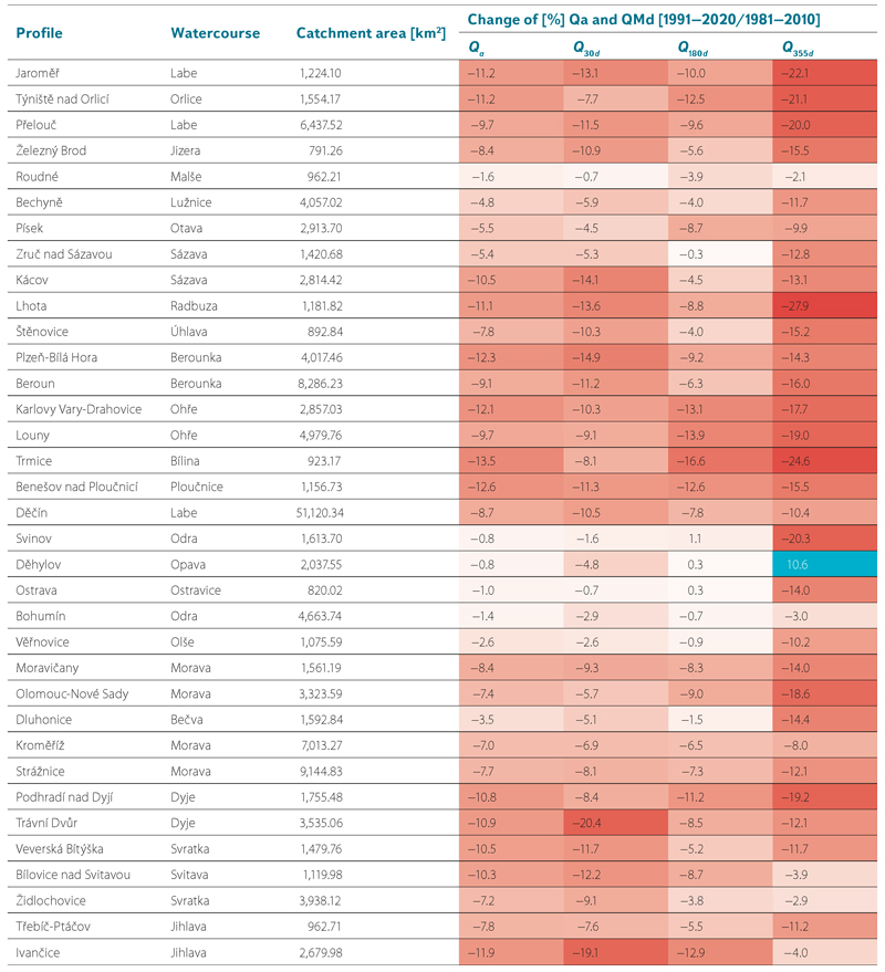
The basic hydrological data characterizing the runoff conditions of a watercourse are the long-term mean discharge Qa and the quantiles of M-day discharges QMd. 304 CHMI water gauging stations, which were continuously monitored between 1 November 1980 and 31 October 2020, passed the statistical analysis of changes in hydrological characteristics. Tab. 1 shows the percentage change in the long-term mean discharge and selected quantiles of M-day discharges derived for the period 1991–2020 and for the period 1981–2010 for 35 selected water gauging stations. To highlight the magnitude of the change in individual characteristics, the cells were colour-coded in shades of red (decrease in characteristics in 1991–2020 compared to 1981–2010) and blue (increase in characteristics in 1991–2020 compared to 1981–2010). At first glance, it is clear that red shades predominate in the table for all hydrological characteristics. With a few exceptions at several anthropogenically affected gauging stations, the runoff characteristics decreased mainly in the period 1991–2020.
Tab. 1. Percentage change of selected quantiles of M-day discharges derived for the period 1991–2020 compared to the period 1981–2010 in selected water gauging stations
To compare the development of water bearing during the period 1981–2020, the percentages of each mean annual discharge in the long-term mean discharge for the period 1981–2010 were calculated for 304 water gauging stations. These percentages were then averaged for each hydrological year and this value serves as a characteristic expressing the percentage of the runoff of that year in the long-term mean discharge (see graph in Fig. 1). The graph shows that when comparing the decades 1981–1990 and 2011–2020, which differ between the current and newly considered reference periods, most of the years 2011–2020 were part of a multi-year dry period that began in 2014 and in some regions lasted until 2019. In the 1980s, only 1984 and 1990 were significantly below mean (< 0.8), the other years were close to the long-term mean 1981–2010 or even above mean. This fact explains the negative changes in the long-term mean discharge at most water gauging stations.
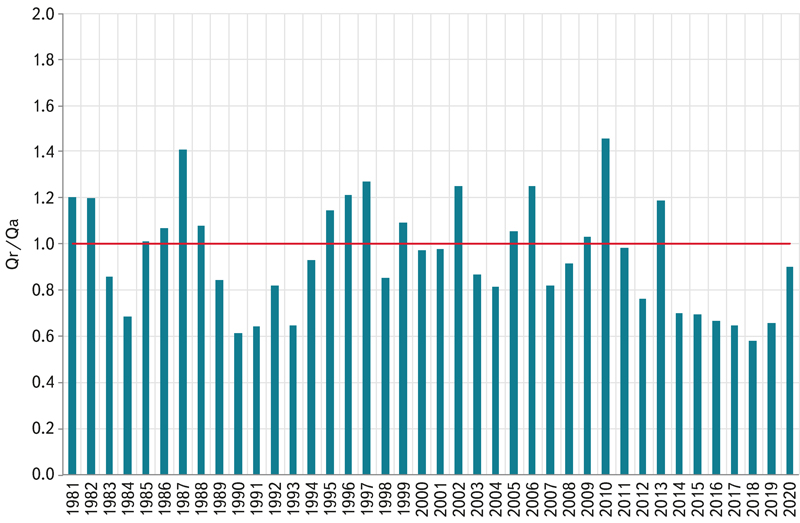
Fig. 1. Mean annual shares of Qr in the long-term mean discharge Qa for the period 1981–2010 in 304 gauging stations (Qa 1981–2010 = 1)
The magnitude of the change in the long-term mean discharge calculated for the period 1991–2020 compared to the period 1981–2010 in the set of 304 water gauging stations ranges from −27% in the Želízy profile on the Liběchovka river to +31% in the significantly anthropogenically influenced profile of the Žermanice profile on the Lučina river. The map in Fig. 2 shows the magnitude of the percentage change in the long-term mean discharge Qa in selected water gauging stations in the period 1991–2020 compared to the period 1981–2010. The average value of the change in the long-term mean discharge calculated in the set of 304 water gauging stations is equal to −7.3%. From a regional point of view, there are the smallest changes in the size of the long-term mean discharge in the Malše and Odra river basins; on the contrary, the largest decreases were recorded at water gauging stations in the upper part of the Berounka, Ploučnice, Svratka, Jihlava and Dyje river basins. From the overall view of the map, it is clear that the reduction in long-term mean discharge is almost across the board.
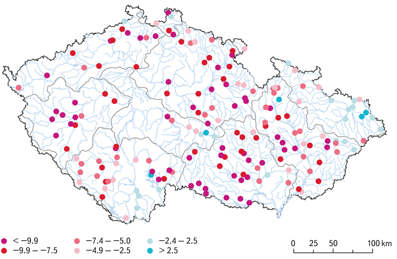
Fig. 2. Percentage differences between long-term mean discharges Qa at selected gauging stations for the periods 1991–2020 and 1981–2010
A largely similar spatial distribution also appears in the results of the calculation of the percentage change in the 30-day discharge Q30d when comparing this characteristic for the period 1991–2020 with the period 1981–2010 (see Fig. 3). As the highest water bearing years from the second half of the 1990s to 2010 are common to both reference periods, the comparison of the decade of the 1980s and the last decade 2011–2020 is again decisive in the case of the magnitude of the change in the 30-day discharge Q30d. In general, the period 1981–1990 was more aqueous than the period 2011–2020, so the average value of the change in the 30-day discharge Q30d in the set of 304 water gauging stations is based on −7.2%.
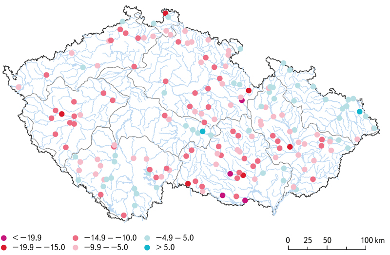
Fig. 3. Percentage differences between Q30d discharges at selected gauging stations for the periods 1991–2020 and 1981–2010
The map in Fig. 4 shows the magnitude of the percentage change of the 355-day discharge Q355d in selected gauging stations in the period 1991–2020 compared to the period 1981–2010. Due to the long-lasting hydrological drought in the period 2014–2019, which continued in certain parts of the country until 2020, the values of the minimum discharge quantiles decreased at most gauging stations. Long-term periods of minimum discharges have been observed during long-lasting precipitation-free periods during the dry years. This caused the average magnitude of the change in 355-day discharge Q355d in the set of 304 gauging stations to be −13.4%.
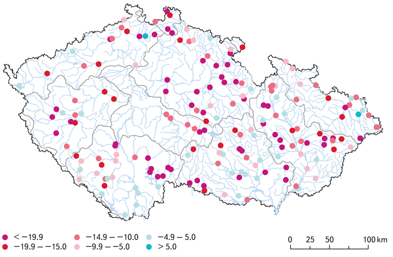
Fig. 4. Percentage differences between Q355d discharges at selected gauging stations for the periods 1991–2020 and 1981–2010
The above-described changes in the size of selected M-day discharge quantiles affected the shape of the flow duration curves of mean daily discharges at gauging stations. The graphs in Fig. 5–7 show the flow duration curves of mean daily dischargesin the period 1981–2010 and in the period 1991–2020 for selected final gauging stations. In the graph in Fig. 5, which shows the flow duration curves of mean daily dischargesfor the Děčín profile on the Elbe river, it is evident that the water bearing decreased throughout the flow duration curve of mean daily discharges. The flow duration curve of mean daily discharges for the period 1991–2020 copies the curve for the period 1981–2010. The shape of the flow duration curve of mean daily discharges for the Děčín profile is influenced by activities on hydraulic structures; the Vltava Cascades reservoirs have the greatest influence on the shape of the flow duration curve of mean daily discharges.
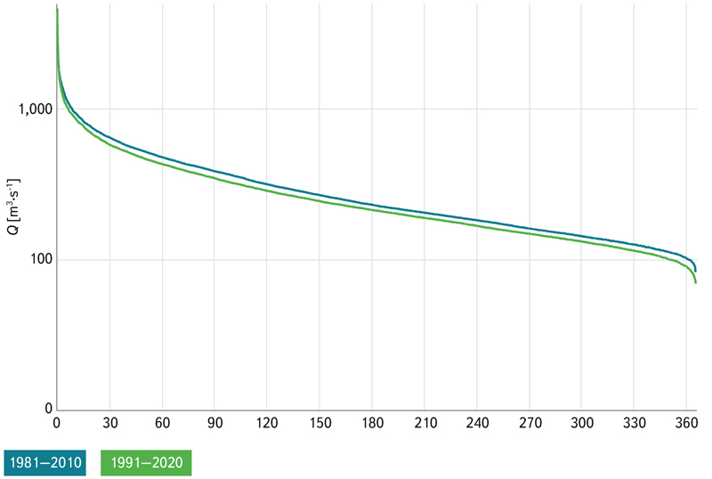
Fig. 5. Flow duration curves at the Děčín gauging station on the Labe River for the periods 1981–2010 and 1991–2020
The graph in Fig. 6 shows the flow duration curves of mean daily dischargesfor the profile of the Bohumín water gauging station on the Odra river. The graph shows that the flow duration curve of mean daily discharges for the period 1991–2020 has almost the same shape as the curve for the period 1981–2010. The reason is the fact that the Odra river basin was the least affected by drought during the 2014–2020 dry season and, simultaneously, there are large reservoirs on the Odra tributaries, operations on which can improve the flows in the watercourses below the hydraulic structures.
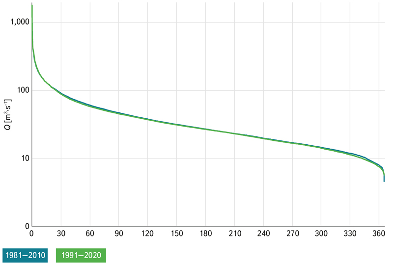
Fig. 6. Flow duration curves at the Bohumín gauging station on the Odra River for the periods 1981–2010 and 1991–2020
The graph in Fig. 7 shows the flow duration curves of mean daily dischargesfor the Strážnice water gauging station on the Morava river. The Morava river basin and its tributaries was severely affected by the drought. The value of the 30-day discharge Q30d decreased in Strážnice in the period 1991–2020 by 8.1% and the 355-day flow decreased by 12.1%.
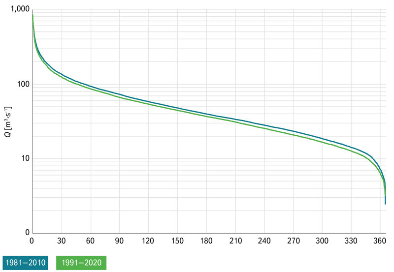
Fig. 7. Flow duration curves at the Strážnice gauging station on the Morava River for the periods 1981–2010 and 1991–2020
CONCLUSION
The results of the comparison of M– day discharges for the reference period 1981–2010 and the considered reference period 1991–2020 show that the quantiles of M-day discharges decreased at most gauging stations. In the set of 304 water gauging stations, the average change in the long-term mean discharge Qa reaches −7.3% and the average change in the 355-day discharge Q355d is −13.4%. The change in the reference period of the hydrological characteristics is made in order to ensure that the hydrological data derived for the reference period best reflect the current hydrological regime.
