SUMMARY
Manual watershed delineation by watershed divides has traditionally been performed by means of an analysis of topographic maps and contour lines. With the availability of digital elevation models, watershed and streams delineation is performed automatically, which reduces the time spent on manual delineation. In this study, we introduce the process of automatic delineation and the models available within the toolbox Arc Hydro Tool Pro, created by the company ESRI for the ArcGIS Pro software. Automatic delineation was implemented by means of different methods for selected watersheds in the Czech Republic, varying in area and elevation. Digital elevation models with different resolutions, from pixel size of 2 × 2 m to 50 × 50 m, were used as the input layer. Next, these delineated watersheds were compared with the current layer of fourth-order watershed divides (valid in 2019). Results of automatic delineation for each watershed, except those in lowlands, show a high overall accuracy. Automatic delineation can be applied not only as an input to hydrological models but also in consequent watershed analysis, for example, with the use of other tools in ArcGIS Pro.
INTRODUCTION
Watershed delineation is the basis for hydrological modelling and analysis. Traditionally, it is carried out by analysing topographic maps and contour lines, which is often a lengthy and challenging process. By using the digital elevation model (here-in-after DEM), which represents the relief of the Earth’s surface, the whole process can be carried out automatically, thus reducing its time demands significantly. Techniques for automatic watershed delineation have been available since the mid-1980s and have been used in several geoinformation systems (GIS) and other applications. The development of these techniques, as well as the emergence of new higher resolution DEMs, form the basis for accurate and rapid analysis. Another important factor is the development of computer technology, which allows more powerful and comprehensive operations to be performed locally and quickly enough. This gradually increases the demand for automated systems which must provide accurate and rapidly available results [1–3].
ArcHydro is a data model, a set of tools and procedures that have been developed over the years to support specific GIS implementations in the area of water resources. Since 2002, it has expanded with more than 300 new tools from the original 30 and it has been widely used in many different projects by a range of users including government institutions, private companies, schools, and general users interested in water resources [4].
This article serves as an introduction to the automatic delineation process that can be performed using the tools in the Arc Hydro Tools Pro toolbox, created by the company ESRI for the ArcGIS Pro software. The automatic delineation itself was then implemented using different methods for selected watersheds in the Czech Republic varying in area and elevation to verify its accuracy and shortcomings in different types of relief.
METHODOLOGY
The basis of ArcHydro is the Hydrology toolset, which is stored in the Spatial Analyst toolbox. The new Arc Hydro Tools toolbox has been extended with new tools and improvements to existing ones. The newest Arc Hydro Tools Pro toolbox, which was used for the purposes of this article, was created for the transition to ArcGIS Pro.
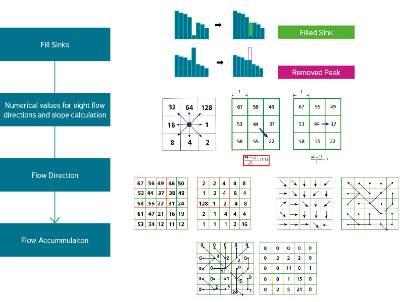
The basic process of delineating and creating a river network using the Terrain Preprocessing toolset is partially illustrated in Fig. 1 and can be summarized in a few steps [6]:
- The Level DEM function – assigns the cells of the input DEM the same value as the values in the polygons of the embedded water bodies layer.
- The DEM Reconditioning – reshapes the relief by “burning” the stream (linear feature) using the AGREE method [7], where the streams surroundings are lowered by entered values. This creates a more distinct cross-sectional profile that may not be completely clear in the input DEM due to the lack of elevation data in the vicinity of the streams.
- Fill Sinks – modifies the terrain´s unevenness by increasing or decreasing the cell value depending on the surrounding cells so that the generated river network is continuous.
- Flow Direction – determines the flow direction for each cell according to the largest difference in values (largest slope) between adjacent cells and produces a raster (D8 method). D-Infinity or Multiple Flow Direction methods can also be selected.
- Flow Accumulation – based on the Flow Direction raster, it adds the number of cells from which water flows into a given cell and assigns this resulting value to the cell. It then creates a raster from all the values.
- Stream Definition – based on Flow Accumulation grid and a user specified treshlod (the number of cells or minimum watershed area), it computes a stream grid. All cells above the threshold value are then assigned the value of 1, all cells below the value are assigned the blank value of “Null”. The smaller threshold value leads to a denser stream network and a higher number of catchments.
- Stream Segmentation – divides streams into individual segments (to the confluence of two streams or between confluences) and assigns a unique identifier to them. All cells in a given segment can thus be distinguished unequivocally from others by a specific “Grid Code”.
- Catchment Grid Delineation – assigns each cell a value that matches the catchment to which it belongs. This value is identical to the value of each stream’s segment. The resulting raster is then converted to a polygon layer using the Catchment Polygon Processing function.
- Drainage line Processing – converts the generated river network raster from step 6 to a line feature class.
Fig. 1. Automatic watershed delineation process [5]
Steps 1 and 2 require the input polygon (water areas) and line (streams) features, respectively, which may make the functions described in the following steps different, but the whole process works without them, too.
To speed up the whole process, the Terrain Preprocessing Workflows toolset [8] can be used, which contains several models from which the user chooses based on the available input data and the type of river network in a given relief. The input data is divided into four categories:
- The user has only DEM (no stream or sink information),
- DEM and known sinks,
- DEM and known streams and sinks,
- DEM and known streams.
The river network type is then divided into three categories: dendritic, deranged, or combined.
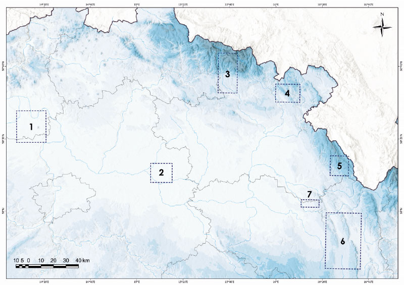
Six watersheds varying in area and elevation were selected to create watershed divides using automatic delineation and the Skořenický potok watershed (Fig. 2) was selected to compare automatic delineation over DEMs with different resolutions and the actual watershed divide layer. Specifically, these were pairs of watersheds, always smaller and larger in area, located in lowlands (Blatnice, Čepel), uplands (Jívka, Třebovka) and mountains (Říčka, Malé Labe). Firstly, polygons (a certain extent or window, identical to Fig. 2) were created around all the watersheds, in which the actual delineation was carried out. Only DMR 5G was used as a base for all watersheds within this delineation. The first model was chosen to be a dendritic river network with DEM only (no stream or sink information), followed by the second model with the layer of streams burnt into the relief model. The stream layer was used from the DIBAVOD digital database [9]. Polygons were generated between these two layers to show the deviation between the actual and generated watershed divides. Finally, the accuracy of the whole delineation was evaluated according to the size of their areas. The current watershed divides layer can be downloaded from: http://voda.chmi.cz/opv/stahnout.html.
Fig. 2. Map of selected watersheds: 1 – Čepel, 2 – Blatnice, 3 – Malé Labe, 4 – Jívka, 5 – Říčka, 6 – Třebovka, 7 – Skořenický potok (Source: DIBAVOD, ArcČR 500 and DMR 5G)
To compare the automatic delineation over DEM with different resolutions and the actual watershed divide layer in the Skořenický potok watershed, four relief models were used – DMR 5G, DMR 4G, DMÚ 25, available from the Czech Geodetic and Cadastral Office´s website (https://geoportal.cuzk.cz) and ArcČR 500 available from Arcdata Prague (https://www.arcdata.cz/produkty/geograficka-data/arccr-4-0) with pixel sizes of 2, 10, 25 and 50 m. Again, the model for dendritic river network with no stream or sink information was chosen.
RESULTS AND DISCUSSION
The first aspect evaluated was the effect of DEM resolution on the automatic watershed delineation. The Skořenický potok watershed was selected as the testing territory, with an area of 17.1 km2, an average slope of 3.72% and an average elevation of 361 m above sea level. It is clear from the resulting values in Tab. 1 that as the DEM resolution decreases, the accuracy of the delineation itself decreases, too. While the deviation from the actual watershed divide is higher than 4% when using DMR 4G, it is more than double for the 25 × 25 m resolution and reaches 12.8% for the lowest resolution of 50 × 50 m.
Tab. 1. Results of the automatic delineation in the Skořenický potok watershed
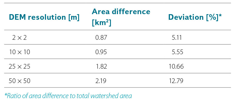
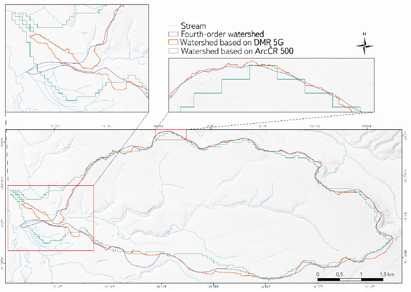
Therefore, it is confirmed that accurate delineation of a watershed depends largely on the quality of the initial DEM, and more precisely, on its resolution [10–12]. A more detailed view of the difference between the generated watershed divides is provided in Fig. 3. It shows that when using a DEM with a lower resolution, a kind of “teeth” due to the pixel size are created, which prevents detailed and accurate delineation.
Fig. 3. Delineated watersheds of Skořenický potok using different digital elevation models
However, the overall deviation is quite significant for such a small watershed for all DEM types. In this case this is caused by the small area in the western part of the watershed with a low slope and a complicated river network. The automatic delineation did not generate a range of the stream and the watershed divide took a different direction. Such an error can be avoided by burning the actual streams into the relief itself. If we used the terrain with burnt streams in the Skořenický potok watershed as an illustration, we would get the overall deviation for DMR 5G slightly higher than 4%.
The delineation results for the six selected watersheds are shown in Tab. 2. The smallest difference was achieved for the largest watershed in terms of area, the Třebovka, where the deviation (excluding burnt streams) was only 0.89%. The two mountain watersheds of the Říčka and Malé Labe had slightly more, with deviations of 1.34 and 1.85% respectively, while another upland watershed, the Jívka, still had a small deviation of 2.35%. The lowland watersheds were generated with the least accuracy. The Blatnice watershed had a deviation of 7.55% and the larger Čepel watershed´s deviation was high – 9.13%.
Tab. 2. Results of automatic delineation in the individual watersheds
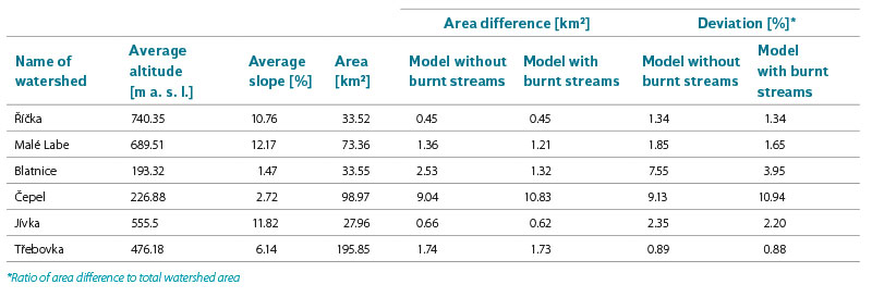
The terrain with burnt stream features has reduced the deviation in all watersheds except the Čepel, where, on the contrary, has been an increase by almost 2%. The high deviations in the Čepel watershed, as in other lowland watersheds, may be caused by the fact that the area is crossed by linear features (mainly motorways and railway linear features) which significantly encroach on the terrain that is otherwise lowland. If the elevation of the feature is then particularly below or above the surrounding terrain, the model may evaluate it as a watershed divide, or as the stream itself, thereby fundamentally altering the course of the watershed, as is the case of the Čepel watershed (Fig. 4). Literature [13] states, inter alia, that features such as artificial streams, low dams or large lakes can form significant sinks in the terrain that affect the accuracy of the results, especially in lowland areas and river floodplains. This results in the generation of an unreal river network, which is further limited by the resolution of the DEM used. The Fill Sinks function is used to remove sinks, but the question is to what extent the given relief should be smoothed. On the one hand, some smoothing is necessary as it removes inaccuracies in the input DEM and a more real surface can be achieved while preserving the topographic characteristics, on the other hand, too much smoothing can change or remove the actual (natural) sinks that are important for the correct description of the relief. Thus, in this case, a proper smoothing of the DEM goes through a well-chosen threshold value to lower or raise the sinks. However, a single chosen value cannot, in the end, correspond to the whole study territory and therefore the intention and scope of the whole study must also be taken into account [14, 15].
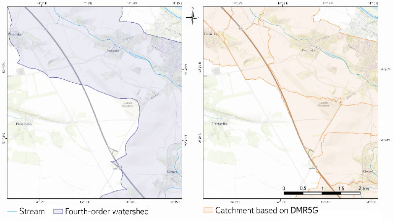
Fig. 4. Impact of a motorway on the automatic delineation of the Čepel watershed and catchments (Source map: Esri World Topographic Map)
Although the burning of the streams into the terrain reduced the deviation in the other basins, in all cases it was only a slight change in the order of tenths or even hundredths of a percent, except in the Blatnice watershed, where it was refined by 3.6%. The results may thus suggest that the burning of streams into the terrain is meaningless in some watersheds, but a closer examination of the resulting watershed divides reveals that the refinement is obvious mainly in the individual catchments, not in the whole selected watershed. In this case, the burning of the streams does not affect the resulting accuracy but could affect subsequent analyses of the watershed or catchment. Thus, the use of stream layers can significantly increase the accuracy of watershed delineation, especially in flat lowland areas [16, 17].
Other refining factors may include the use of the layer of water areas, thus providing a link between the river network and lakes, coastal lagoons or estuaries [18]. For example, the freely available SRTM (Shuttle Radar Topography Mission) Water Body Dataset layer from the USGS at 30 × 30 m resolution can be used for this purpose (https://earthexplorer.usgs.gov). Methods for automatic delineation in drainage-free areas using the SRTM DEM (Digital Elevation Model) are presented, for example, by Liu [10].
Last but not least, setting the threshold value to generate a river network can play a role. In the models used for this study, this value is the default one (automatically evaluated by the model on the basis of raw DEM). However, selecting a lower value, thereby densifying the river network, may result in a more accurate delineation [19].
Although the “accuracy” of watershed delineations is compared throughout the article, the layer of the actual watershed divides cannot be taken as a basis free of any errors. It is a layer that is regularly updated but contains a large number of areas where the course of the watershed divides is not entirely clear. The automatic delineation, on the other hand, respects the relief exactly and determines the flow direction precisely for each pixel. On the other hand, it cannot correctly evaluate certain specifics, such as streams flowing under the surface or man-made channels, which are taken into account when watershed divides are created manually. The results should therefore be taken with a grain of salt and seen as a possibility of using ArcHydro Pro tools in the latest view of the Czech Republic´s relief. In the future, it would be useful to analyse a larger number of watersheds with different areas, on differently rugged relief, and to find out what threshold values (for filling/adjusting sinks or river network density) would best describe the given terrain and thus provide the basis for the most efficient automatic delineation. At the same time, more attention needs to be paid to watersheds in the lowlands, in areas with flat terrain, where studies have shown the greatest deviations from the actual watershed divides. Consequently, more evaluation criteria based on the shape or length characteristics of the watershed divides should be used to assess the accuracy of the delineation. The lengths of watershed divides in the Skořenický potok watershed (Fig. 3) can be used as an illustration. Here, the length of the actual watershed divide is 21.2 km, the DEM-generated length with a resolution of 25 × 25 m is almost 27 km, and the DEM-generated length with a resolution of 2 × 2 m is almost 31 km, which at first glance does not correspond to the map or the resulting deviations. The high resolution of DMR 5G results in many small “teeth” on the generated watershed divide, which increase its overall length. If we wanted to evaluate according to this criterion, we would first have to choose the most appropriate level of generalization of the watershed divide. For example, if we smoothed this watershed divide according to the Smooth Line function with a tolerance of 100 m, the resulting length would be 22.1 km, just under a kilometre longer than the actual length of the watershed divide.
USES
Automatic watershed delineation can be used mainly as an input to hydrological models such as SWAT, HBV, HEC-GeoHMS or ILWIS. The studies that have been completed focus on comparisons of different delineation methods and procedures rather than on differences in accuracy between models, so it is not possible to say unequivocally which model is more appropriate. However, in general, their conclusions are in agreement with the results of this study, especially in that the largest differences in delineation are formed in lowland areas with flat terrain (or coastal areas) and delineation accuracy is highly dependent on the resolution of the input DEM [20, 16, 17]. Larger scale applications can be found, for example, in the Pan-European River and Catchment Database [18], which contains data on river networks, lakes and watershed boundaries across Europe. These are based on DEMs with 100 m resolution, thus creating the conditions for medium- and small-scale modelling. SRTM elevation data, a derived shoreline layer and selected natural sinks served as additional input data for the watershed delineation and the generation of the river network. If necessary, in a very flat terrain where it was not possible to unambiguously determine the course of the stream according to the DEM, a reference network of streams was used. The network of streams and its related watershed were generated according to the classical D8 method to determine the flow direction and the Soille and Gratin algorithm [21] to determine the flow accumulation. Three new algorithms [22] were used to solve the problem of stream flow in a flat terrain, and a part of the terrain in the flow direction at artificial sinks was cut out instead of filling the sink itself, thus preventing further extension of the flat terrain. Similar or additional methods and algorithms for optimum sink removal have been the focus of studies [23, 24], which could also provide guidance on how to refine delineation and could be applied to the territories selected in this study.
The Czech Hydrometeorological Institute is currently in the process of updating the watershed divides over DMR 5G. The editing is being done manually in ArcGIS Pro with the ZABAGED stream layer and using automatically generated contour lines and contour lines derived and provided by the Czech Geodetic and Cadastral Office [25]. At the same time, editors can use the HydroDEM toolbox to generate watershed divides automatically. Thus, automatic delineation is mainly used as an auxiliary tool in this case, especially in flat lowland areas where the watershed divides are not as clear as in watersheds with a higher slope.
CONCLUSION
This paper has presented the possibility of automatic delineation of watersheds and river networks using the tools in the Arc Hydro Tool Pro package in ArcGIS Pro environment. The process of automatic delineation itself was described and applied to selected watersheds in the Czech Republic within evaluation of its functionality and accuracy. The most accurate watersheds were generated in the mountainous and hilly areas (deviation of watershed size from the actual watershed divides up to a maximum of 2.4%), and the least ones in the lowland areas. The results are consistent with the results of other studies to date, where the largest deviations also occur in lowland areas with flat terrain. Furthermore, the decreasing accuracy of delineation with lower resolution of the input DEM was also confirmed. Possible ways of modifying the DEM and changes in the watershed divide generation procedure to improve delineation accuracy were discussed. Within further research, it was proposed to apply automatic delineation to a larger number of watersheds with a focus on lowland areas. In particular, the resulting accuracy could be influenced by modifying the DEM – both through the input layer of water areas and through different options of sink modification. Thus, automatic delineation using the tools in the Arc Hydro Tool Pro package together with a DEM of a sufficiently high resolution for the purpose of the given study can be recommended as a powerful and sufficiently accurate tool.
The paper has been peer-reviewed.
